Training Log Archive: JanetTIn the 31 days ending Oct 31, 2020:
| |||||||||||||||||||||||||||||||||||||||||||||||||||||||||||||||||||||||||||||||||||||||||||||||||||||||||
| « | » |
| » now | |||||||||||||||||||||||||||||||||||||||||||||||||||||||||||||||||
| Th | Fr | Sa | Su | Mo | Tu | We | Th | Fr | Sa | Su | Mo | Tu | We | Th | Fr | Sa | Su | Mo | Tu | We | Th | Fr | Sa | Su | Mo | Tu | We | Th | Fr | Sa | ||||||||||||||||||||||||||||||||||||||
Friday Oct 30, 2020 #
Walking 50:41 4.54 km (11:10 / km) +52m 10:34 / km
ahr:97 max:121 shoes: Altra Torin Plush4-silv
These two walks were actually one, but at some point I stopped my watch (to cross Saucon Creek Rd) and forgot to restart it until it was giving me a "switching screens" alert. I stopped the track, uploaded it to GC (had my phone with me), and saw I still had most of where I had been to that point, so started a new track from there. I missed the nuance of the start of Saucon Dr, but not much distance.
Walking 15:40 1.24 km (12:40 / km) +2m 12:33 / km
ahr:97 max:111 shoes: Altra Torin Plush4-silv
Thursday Oct 29, 2020 #
Yoga 25:00 [0]
Wednesday Oct 28, 2020 #
Walking 1:17:23 7.0 km (11:03 / km) +15m 10:56 / km
ahr:93 max:111 shoes: Altra Torin Plush4-silv
Tuesday Oct 27, 2020 #
Walking 1:31:30 9.06 km (10:06 / km) +16m 10:00 / km
ahr:98 max:140 shoes: Altra Torin Plush4-silv
Ankles felt okay throughout, but right knee isn't happy today.
Monday Oct 26, 2020 #
Walking 1:17:47 6.63 km (11:44 / km)
ahr:88 max:123 shoes: Altra Torin Plush4-silv
Sunday Oct 25, 2020 #
Walking 19:08 1.2 km (15:57 / km) +18m 14:50 / km
ahr:104 max:117 shoes: 2019 VJ Falcon 6.5 scot
Orienteering 1:27:41 *** 3.87 km (22:39 / km) +56m 21:07 / km
ahr:106 max:152 spiked:12/13c shoes: 2019 VJ Falcon 6.5 scot
Nice area with good visibility, but tough footing (ankles of steel needed!). I taped my ankles *and* took a hiking pole today to make keeping my balance easier.
There was abundant blueberry, from knee to waist high in places; and less abundant greenbriar (mostly in nominally wet areas mapped as marshes (but dry now), plus scattered smallish scrubby oaks and pines (I did also notice one hemlock). Rocky underfoot in many places (though not as much as at Stony Run!) so I was glad to have the hiking pole there. Rock features were mostly well-mapped, though in some cases the tone played when I wasn't near any outstanding rock.
I liked the hilltop control (#10, I think), from which I could see well across the valley. I approached from below the large cliff line, but the view might be even better from above the cliffs. I dropped down to the trail in a rocky but passable area and only later noticed a distinct trail a bit to the north in the terrain (do the ATVs go up there???) and on the map.
Walking 21:19 1.29 km (16:28 / km) +31m 14:42 / km
ahr:105 max:135 shoes: 2019 VJ Falcon 6.5 scot
Saturday Oct 24, 2020 #
Walking 1:16:35 7.32 km (10:28 / km) +35m 10:13 / km
ahr:96 max:130 shoes: Altra Torin Plush4-silv
Started out partly sunny and 68, but the breeze brought clouds and dropped the temp to 64 by the time I got back.
Friday Oct 23, 2020 #
Biking (Gravel trail) 1:29:23 23.32 km (3:50 / km) +32m 3:48 / km
ahr:98 max:149 shoes: Trek DS 3 hybrid
Upper 60s and overcast until just before we turned around when the sun came out. Nice day!
Walking 44:22 2.55 km (17:26 / km)
ahr:80 max:139
Thursday Oct 22, 2020 #
Note

Walking 1:16:10 6.77 km (11:15 / km) +73m 10:40 / km
ahr:93 max:123 shoes: Altra Torin Plush4-silv
Wednesday Oct 21, 2020 #
Walking 1:43:35 9.33 km (11:06 / km) +11m 11:02 / km
ahr:92 max:126 shoes: Altra Torin Plush4-silv
Mid 60s, humid, and overcast almost the entire time; a bit of light mizzle the first 1/2 hour or so; the sun peeked out for the last 10 minutes.
Enjoyed the various Halloween decorations some people have put out.
(The only wildlife spotted were squirrels, a couple of crows, a blue jay, and not much else.)
Tuesday Oct 20, 2020 #
Walking 1:34:51 8.9 km (10:40 / km) +104m 10:04 / km
ahr:99 max:138 shoes: Altra Torin Plush4-silv
Monday Oct 19, 2020 #
Walking 1:12:00 7.32 km (9:50 / km) +59m 9:27 / km
ahr:106 max:144 shoes: Altra Torin Plush4-silv
Low 60s and overcast.
Biking (rail trail) 1:12:26 14.78 km (4:54 / km) +50m 4:49 / km
ahr:108 max:153 shoes: Trek DS 3 hybrid
Mid 60s and mostly cloudy, though the sun was peeking out during the last part of the ride. Checked out the pump track near parking (about a dozen kids riding there), then started back on the trail to intercept Glen which I did within minutes of heading out.
A lot of faerie/gnome/elf villages have been set up along the trail, particularly within a mile or two of parking areas...most consist of some birdhouses and figurines. There was also a plastic-dinosaur village shortly before I turned around close to 4 miles up the trail from where I started. ;-)
Sunday Oct 18, 2020 #
Walking warm up/down 5:28 0.36 km (15:19 / km) +14m 12:52 / km
ahr:100 max:116 shoes: Inov8 ORoc280-B 2013-10
Orienteering 1:57:24 *** 5.07 km (23:08 / km) +148m 20:11 / km
ahr:101 max:146 spiked:17/19c shoes: Inov8 ORoc280-B 2013-10
Fun course, but I went slowly (taped both ankles) to avoid any more ankle twists on the rocky ground which was in a lot of places. Woods were open where mapped as white; green was largely smaller pine saplings. Lots of blueberry in some places but not all over; lots of ferns too. Visibility excellent except in the saplings.
Waited for tone a couple times (#5-boulder especially), and left #4 in wrong direction, but otherwise had a great time given the ankle problem. Nice area.
Walking 33:49 2.85 km (11:52 / km)
ahr:98 max:111
Saturday Oct 17, 2020 #
Walking 1:03:41 6.34 km (10:03 / km) +54m 9:38 / km
ahr:105 max:136 shoes: 2019 Altra LP4.0 9 rspb
Trail is pretty shaded most of the way so this would be a good mid-summer rail trail ride. Had planned about an hour while Glen ran, and turned around just a bit after 30 minutes because there was a terrain feature to check out...an old slate quarry. There were other quarry remnants visible farther south on the trail as well. Saw one bow hunter scanning along the powerline break when I was on my way back.
Glen caught up to me a few road crossings N of where we parked. When I got back to parking he'd been a ways south and said there was an interesting bridge across the Little Bushkill Creek about 1/2 km down the trail, so I extended my walk (separate track).
Walking 11:10 1.0 km (11:07 / km)
ahr:105 max:148 shoes: 2019 Altra LP4.0 9 rspb
A short way north of the bridge on the W side there was a large boulder?? off in the woods with a tree and moss growing on it. If there hadn't been other people on the trail I might have gone to check it out.
Friday Oct 16, 2020 #
Walking 1:12:45 7.56 km (9:37 / km)
ahr:107 max:132 shoes: Altra Torin Plush4-silv
Thursday Oct 15, 2020 #
Hiking 2:41:00 * 7.5 km (21:28 / km) +106m 20:03 / km
ahr:93 max:142 shoes: 2015 Altra LP2.0-9 lime
We hiked up the road first, then turned right to take the loop of Blueberry Trail beyond the road. Power line road to Stonehenge Trail, along which were some impressive 1.5-2.5m blocky boulders of mostly conglomerate with some sandstone. We stopped near the viewpoint to eat sandwiches we'd brought, then continued on, eventually joining the Conglomerate Loop (we did the uphill portion). The vegetation was much lower here and it smelled like the area had been burned (the website above mentions planned burns). When we reached another road we crossed it to take Bruised Ego back to the parking area. Mountain biking is allowed here, accounting for some of the trail names, I think. Too technical for me.
I was going to take hiking poles to help me keep my balance and not reinjure my ankle but left them at home, so put on extra taping to stabilize it, and did fine with just that (and watching where my feet were going). Not many birds (blue jays, some kind of small hawk, a few butterflies) but nice views and neat woodlands.
We made a Starbucks stop in Scranton and then continued on to Archbald Pothole State Park, and walked around there some after looking into the pothole (but didn't track it). And we went to check out the Lackawanna train viaduct over the Tunkhannock Creek, 2,375' long, 240' high, with 10 concrete arches across the broad creek valley. Impressive.
Note
Wednesday Oct 14, 2020 #
Hiking 1:46:29 5.57 km (19:08 / km) +35m 18:33 / km
ahr:87 max:127 shoes: 2015 Altra LP2.0-9 lime
Tuesday Oct 13, 2020 #
Walking 1:02:47 6.41 km (9:48 / km)
ahr:105 max:152 shoes: 2019 Altra LP4.0 9 rspb
Low 60s, overcast.
1" of rain from TS Delta.
Monday Oct 12, 2020 #
Yoga 50:00 [1]
Sunday Oct 11, 2020 #
Walking 1:40:11 9.69 km (10:21 / km) +163m 9:32 / km
ahr:106 max:148 shoes: Altra Torin Plush4-silv
Saturday Oct 10, 2020 #
Walking 1:05:10 5.63 km (11:35 / km) +35m 11:14 / km
ahr:92 max:122 shoes: Altra Torin Plush4-silv
Friday Oct 9, 2020 #
Hiking 1:34:17 5.83 km (16:10 / km) +143m 14:24 / km
ahr:95 max:141 (injured) shoes: 2015 Altra LP2.0-9 lime
I made it up to Camp Shehaqua about the time Glen finished the course, so we walked back to the car together.
Biking 1:15:29 17.74 km (4:15 / km) +117m 4:07 / km
ahr:136 max:185 shoes: Trek DS 3 hybrid
Wore HR strap, but am pretty sure it didn't have good contact. 185 seems rather high. :-)
Thursday Oct 8, 2020 #
Walking 1:13:10 6.55 km (11:10 / km)
ahr:96 max:125 (injured) shoes: Altra Torin Plush4-silv
I had taken yesterday's tape off, but re-taped before this outing. Only some periods of tenderness; otherwise an almost normal walk, albeit a bit slower than I've been doing (didn't think pushing speed was a good idea).
62, sunny and breezy with scattered clouds, so a long-sleeved shirt felt right even though I pushed the sleeves up occasionally.
Wednesday Oct 7, 2020 #
Walking 26:52 1.8 km (14:57 / km)
ahr:91 max:109 (injured) shoes: Altra Torin Plush4-silv
Low 70s, sunny, and quite breezy.
Tuesday Oct 6, 2020 #
Hiking 1:22:26 5.84 km (14:07 / km) +160m 12:26 / km
ahr:100 max:128 shoes: 2019 Altra LP4.0 9 rspb
The track is pretty wonky as I didn't jump around the mountain but stayed on the trails, so distance/climb are probably a bit less.
Shortly before reaching the parking lot at the end, though, I wasn't looking where my foot was stepping and my right ankle turned over on a piece of broken pavement (old road bed parallel to Mountain Rd). I could walk on it back to the car, but I'm icing it now. This may cut into my mileage for the month. :-(
Monday Oct 5, 2020 #
Biking (Dirt) 59:55 8.33 km (7:12 / km) +70m 6:54 / km
ahr:127 max:155 shoes: Trek DS 3 hybrid
Mid 60s and partly cloudy, cool to start in short sleeves but I warmed up quickly. :-)
Same route as last time here except I did the fire road and Cold Spot counter-clockwise. Otherwise exactly the same, so I borrowed distance/time
https://www.attackpoint.org/viewlog.jsp/user_49/pe...
Sunday Oct 4, 2020 #
Orienteering race 1:09:43 4.59 km (15:11 / km) +82m 13:56 / km
ahr:121 max:154 spiked:6/10c shoes: Inov8 ORoc280-B 2013-10
Not clean to 2, 6, 10; relocated on 8 from the stone wall segment to the east. Forgot to take splits at 1, 4.
Didn't feel like subjecting myself to a longer course on this green map; this was plenty and I found plenty of low prickly stuff. But it's another beautiful, sunny fall day with temps in the mid 60s.
Walking 6:26 0.51 km (12:43 / km)
ahr:102 max:106 shoes: Inov8 ORoc280-B 2013-10
Hiking 1:38:28 5.37 km (18:20 / km) +58m 17:24 / km
ahr:103 max:137
We may have missed the better part of the quarry. Someone hiked it in winter and found more rocks.
Woods had large trees but lots of greenbriar and raspberry undergrowth.
We did see a bird which
Preserve map:

Giant quart boulders near the Yellow trail:

Swainson's thrush

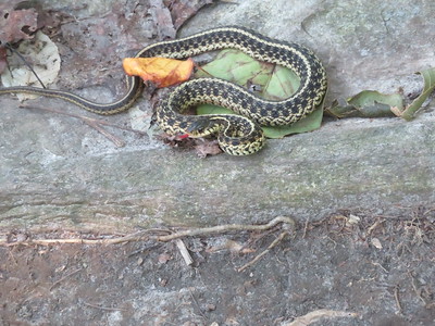
Snake


Saturday Oct 3, 2020 #
Walking 47:55 4.91 km (9:46 / km) +43m 9:21 / km
ahr:112 max:150 shoes: Altra Torin Plush4-silv
Walking 13:01 1.17 km (11:05 / km)
ahr:108 max:121 shoes: Altra Torin Plush4-silv
Friday Oct 2, 2020 #
Walking 31:51 3.32 km (9:36 / km)
ahr:102 max:125 shoes: Altra Torin Plush4-silv
62, breezy and sunny.
Walking 1:07:00 6.86 km (9:46 / km) +39m 9:30 / km
ahr:111 max:144 shoes: Altra Torin Plush4-silv
Thursday Oct 1, 2020 #
Note
I have 5.021 miles to count for today. :-)
Walking warm up/down 14:05 0.97 km (14:35 / km) +79m 10:20 / km
ahr:114 max:136 shoes: Inov8 ORoc280-B 2013-10
Mid 60s and sunny...another gorgeous day in the Poconos.
Orienteering 1:33:32 *** 5.05 km (18:31 / km) +97m 16:54 / km
ahr:114 max:156 spiked:11/13c shoes: Inov8 ORoc280-B 2013-10
I had planned to use UsynligO along with the map but realized about halfway through the drive up that my phone was sitting on the end table in the living room.... So I had to be sure where I was and actually find the circled features before taking a split. ;-) (or relocate the regular way)
The woods were just as nice as they've been before (except for one place with greenbriar, but you can stomp it down as you go), and I enjoyed this course which took me a few places I've been before (around #9, for which I'm glad, because I keep getting mixed up there) and a number of areas I hadn't visited yet (11-12). To get from 11-12 you have to get past a very long, high cliff or a very loose-rocky spur...I climbed up the reentrant around the spur to get to the less scary other side.
En route to the last control I saw a couple-foot-high stone wall along the trail (probably old access road), very well made. And a neat looking spider whose web I had to move to get past it on the trail. (The one I saw had a yellow back, not orange, so probably a male, considering the photos at the link. This spider is also called a Halloween spider. ;-)
Not sure about the depression at the last control, though I saw a likely candidate; and I didn't actually reach the trail junction for the finish, but I was close.
Orienteering 25:16 *** 1.42 km (17:51 / km) +51m 15:06 / km
ahr:115 max:149 spiked:4/5c shoes: Inov8 ORoc280-B 2013-10
Walking 9:22 0.64 km (14:33 / km)
ahr:118 max:125 shoes: Inov8 ORoc280-B 2013-10