Training Log Archive: hamletIn the 7 days ending Apr 23, 2023:
| |||||||||||||||||||||||||||||||||||||||||||||||||||||||||||||||||||||||||||||||
| « | » |
| » now | ||||||||||
| Mo | Tu | We | Th | Fr | Sa | Su | |||||||
Sunday Apr 23, 2023 #
Orienteering (Junior Contour Training) 1:00:00 [0] ** 1.0 km (1:00:00 / km) +50m 48:00 / km
2c shoes: VJ Falcons
Thanks to Matt for hanging the streamers, and Jon and Adam for instructing and picking up streamers!
total controls: 23
Orienteering (Fountainhead Central - Gr) 1:13:32 *** 7.01 km (10:29 / km) +201m 9:10 / km
ahr:129 max:194 11c shoes: VJ Falcons
ran with oliver, so ofc there were a few stops/impromptu route changes when other dogs were involved. Felt pretty solid until going to 8, that's where my energy was really disappearing.
Routegadget
4-5 I tried to contour and ended up too high so much for this morning's junior training :')
6-7 I was FLYING on that trail
7-8 I was worried about getting into the out of bounds if I went straight so I went to the trails, I wanted to take the large trail down the hill but there was a person with 2 dogs ahead of me so that's why I returned to the indistinct trail instead.
8-9 annoying corners of out of bounds
11-F I wanted to go up one spur to the west than I ended up on, would've been better if I stuck to the trail this time.
total controls: 34
ticks found: 1 (pulled it off my back on the way to control 8)
yearly tick count: 1
Saturday Apr 22, 2023 #
Orienteering (Crooked Compass) 7:45:50 [3] *** 24.27 km (19:12 / km) +880m 16:15 / km
ahr:125 max:188 21c shoes: VJ Falcons
only slept 3.5 hours before this so I'm not sure how we survived
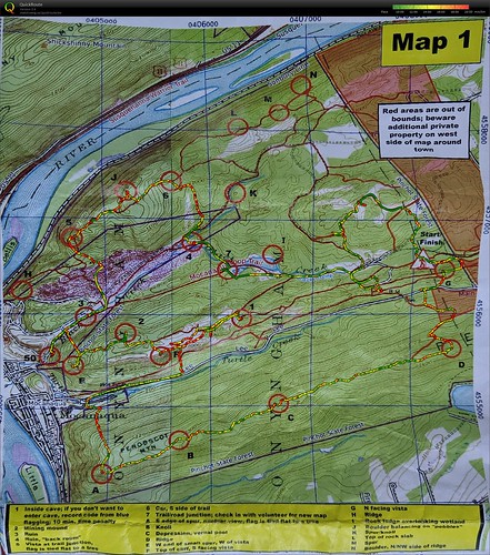
So the race went like this: We got Map 1 when we checked in and were allowed to plan before the start. The points 1-7 were mandatory, all others were optional. Control 7 had to be the last point we went to on map 1, because there they'd take our punchcard for map 1 (manual punching baybeee) and give us Map 2 and a new punchcard.
My mom and I wanted to try to clear the course (especially since we had no idea how short/long it might be), so we started out going to G and then to D, C, B, A, since that was the one area of the map that would be annoying to get to later on. There was a nice trail on the top of that ridge so it was a pretty pleasant start. We kinda quickly realized that we weren't gonna clear the course. So this decision cost us at least 2 points (if we would've done everything on map 1 except for ABCD we would have gotten 2 more points on that map, and maybe would have been done with it quicker and had more time on map 2).
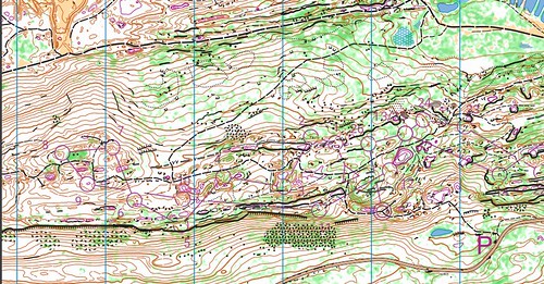
After hitting A we were deciding how we were going to collect the controls on the next ridge. We decided to go up to 1 first, but we didn't estimate distance properly and thought we saw the trail leaving the road so we turned off, thought we had just lost the trail, and kept going straight uphill to try and find another trail (that one that it looks like we crossed didn't exist). So we ended up near F, thinking we were near 1, and we saw Howie (who was looking for F) and went to look for 1. It turns out the trail intersections were represented by tiny ticks along the trail, thankfully we figured this out very quickly. We were also in the area that I recognized from PA house back in 2020. Goddamn I missed Greg's KP map of the area.
1 was in a really cool (literally) cave. Then we went to go search for F, in the area the map didn't fit at all. We were stumbling around towards it, and lots of others were looking for it. Just as we were about to give up on looking for it, I spotted it. That was probably the biggest relief. Both of us were feeling miserable at this point. Frustrated with the map, already exhausted, and considering cutting the rogaine to 4 hours instead of 8, but finally finding F and leaving the super technical area gave us our motivation back. We hit 2, then E, then down to 50 (itwasinaclimbingareaohmygodiwannaclimbthere), up the trail to 3.
That pink-ish area between 3 and 5 was basically mounds of gravel. And no, we didn't mean to leave the trail that early. Technically we didn't, the trail just led differently than it did on the map. Then it ended at the end of the gravel, so we had to navigate back to the trail.
Then the hill up to 5. My mom was suffering. I could tell she had no energy left at this point. Meanwhile I somehow just trudged up the hill like I was on a stairmaster or something. It was super steep but I just had the mentality to just get it over with and rest at the top.
Then we hit J (I loved everything about this control), and then 6, and down the hill to 4 (Ken Walker Sr. helped us a bit cuz we got distracted at smaller ruins and told us that we "wouldn't be able to miss it" and yep those were the tallest ruins I've seen in the middle of the woods like this). Then we ran over to 7 to get map 2 with an hour and a half left.
here's what the KP map of the area around 1 and F looked like for reference (the purple contours are depressions):
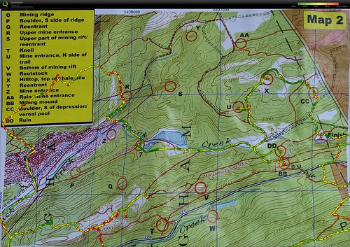
So map 2. My initial idea was to go to P, then Q, V, BB, DD, and finish, but my mom was a lot more tired than me and didn't want to go up the ridge again (which fair enough). She convinced me to go to BB and DD first, and if we had time, we'd get Q and maybe even X and CC. And we did have time, we were booking it tbh (well, compared to the rest of the race). I got that adrenaline surge that I usually get for the last control/finish on normal courses, cuz I knew we were basically at the end, but when I thought about it... we had 1.5 hours left. Basically a whole green/red course. Wild how the mentality changes.
My mom also fell just before we hit CC. She twisted her knee somehow and for a sec she was worried she wouldn't be able to get up. I was worried too, I started thinking if I'd be able to carry her to the finish (we had 25 minutes left, we were so close), but thank goodness she was able to get up and was fine walking. Scared the crap out of me, though.
All in all, I'm satisfied. Definitely not our best performance, but we didn't take any breaks (other than the ones standing around planning our route or fishing a water bottle out of our packs), and we still got 3rd place despite our... uh... questionable preparation and game plan.
oh and we also found tons of cool rocks and took some of the small ones with us :)
total controls: 21
Friday Apr 21, 2023 #
walk/jog (Monocacy NRMA) 39:07 5.24 km (7:27 / km) +75m 6:58 / km
ahr:158 max:197 shoes: ASICS T6L0N
Thursday Apr 20, 2023 #
Running (HoCo Conservancy) 23:03 3.36 km (6:52 / km) +65m 6:15 / km
ahr:161 max:191 shoes: ASICS T6L0N
Wednesday Apr 19, 2023 #
Running (St Mary's College ruins) 35:07 4.7 km (7:29 / km) +144m 6:29 / km
ahr:162 max:189 shoes: ASICS T6L0N
Maybe i overestimated how much hills i can handle.
Tuesday Apr 18, 2023 #
Running (St Mary's College ruins) 35:23 5.0 km (7:04 / km) +100m 6:26 / km
ahr:157 max:190 shoes: ASICS T6L0N