Training Log Archive: edwarddesIn the 7 days ending May 30, 2013:
| |||||||||||||||||||||||||||||||||||||||||||||||||||||
| « | » |
| » now | ||||||||||
| Fr | Sa | Su | Mo | Tu | We | Th | |||||||
Thursday May 30, 2013 #
Park-O race 20:20 [3]
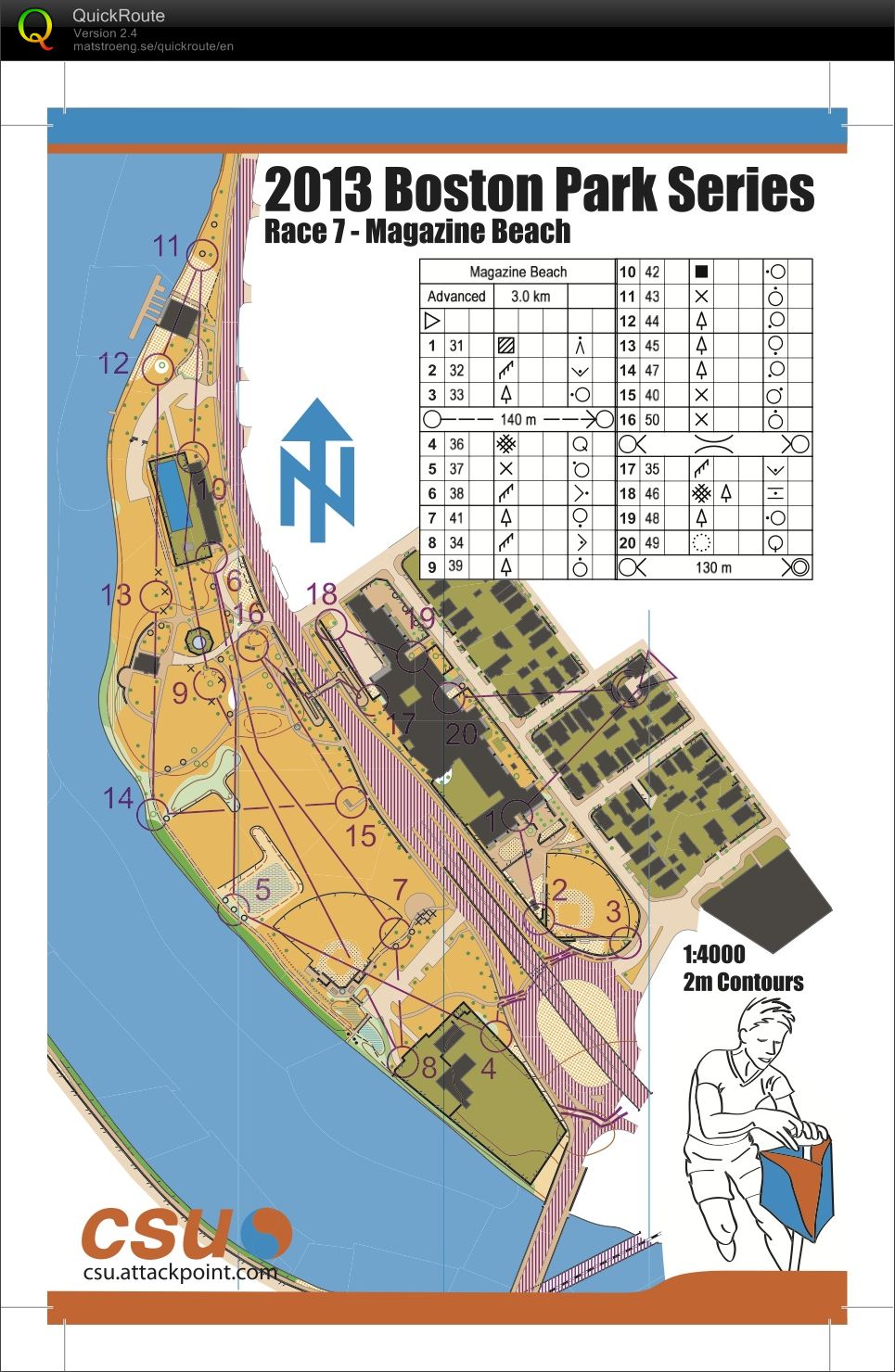
 map (Stolen from Alex's Doma).
I had two goals going into this, beat Alex, and beat Mika. That would secure my place ahead of both of them in the points list. Knowing it was a flat open sprint, I went out really hard to see how long I could hang on. Turns out that was till ~8, at which point the heat was really getting to me and I really didn't want to run back across the fields anymore.
1) made the right choice to go east out of Barbs driveway. The gate through the fence directly across from the street wasn't open, so I spent a few seconds opening it for everyone behind me.
3-4) With the overpass closed, its mostly gridlocked traffic around the rotary, which makes crossing the roads easy. There are police out directing traffic, and they looked confused as to why all these people kept running out into the road with maps.
8-9) stayed left of the marshes, and then cut through between the fences around the soccer field. Felt like I should have gone left of the baseball field and then around its perimeter, or stayed left the whole way to the control.
11-12) Saw Hilly I think at the boat house. Someone said something to me as I ran by, and I expected it to be someone getting annoyed at us for running around their boats. Looked up confused and they said something else and laughed, which gave it away as Hilly. Was very tired and confused, so may have muttered something unintelligible back.
16-17) biggest hill on the map. Really slow up and over the bridge, but was also reading ahead on where 17 and 18 actually were and reading my clues.
Map:
I'm really happy with how the map turned out. It had been really nasty weather for a while, lots of rain which makes mapping hard, so I didn't get a final map file to Dave until Tuesday night. I like to try and go back over the terrain with a well printed map at final scale, but there wasn't time for that, so when I picked up the maps from TPI thrusday morning was the first time I had seen a decent printout at 1:4000 (my inkjet does a really crappy job printing scattered trees vs yellow open, and the fine lines are hard to read).
There are still a few areas that I would fix, especially after talking with everyone after they ran.
The contour line across the center of the map implies much more detail then is really there. The formline hill is prominent though. The formline hill at 16 was not as much.
The playground equipment at 9 I drew as small black lines showing its shape. The problem is that from a distance that is what you see, but the x's for the tables are what are more prominent on the map.
I think there are a couple more places that could use white around the trees. My standard is that if there is grass under the trees that is mowed, then it is yellow, but if there are branches in the way of you running through the area, or there is a skirt of branches that droop down to ground level, then there should be a white circle.
I also played around in the printing with a set of rich greys instead of just 20% black. Kinda worked for the canopies. Didn't work for 50% black in the buildings (too dark), and really screwed up the 50% black in the impassable hedges.