Training Log Archive: FanaticIn the 7 days ending Dec 5, 2011:
| ||||||||||||||||||||||||||||||||||||||||||||||||||||||||||||||||||||||||||||||||||||||||||||
| « | » |
| » now | ||||||||||
| Tu | We | Th | Fr | Sa | Su | Mo | |||||||
Monday Dec 5, 2011 #
Road running 47:00 [3] 5.0 mi (9:24 / mi)
Out to Woods Pond and back; such a nice day, weatherwise, that I just had to get out. Was going to take it easy, but that didn't happen quite as much as it should have.
Sunday Dec 4, 2011 #
Event: WCOC Sessions Woods
Orienteering 1:05:30 [3] 6.1 km (10:44 / km)
I had never been to Sessions Woods until today--quite interesting terrain, but a bit scratchy in spots. I struggled a bit, both the the running and the orienteering although I managed to avoid any really stupid mistakes. Ran the red course, to get my money's worth. The controls were placed on clearly visible features, so no luck involved, if you were anywhere near the feature.
Edit: Well, only one stupid mistake--I missed a control :-(
Edit: Well, only one stupid mistake--I missed a control :-(
Saturday Dec 3, 2011 #
Trail Running 1:45:00 [3] 7.15 mi (14:41 / mi) +1157ft 12:44 / mi
Starting from Woods Pond, I was planning on just doing an out and back, but was distracted by what looked like a trail that I hadn't noticed before, so off I went. As usual, the trail didn't go that far before it petered out. No problem, I'll just bushwack uphill until I hit a trail. While that went as planned, the 'trails' in October Mountain just suck--they are world class selection of movable rocks covered with 6" of oak leaves, with lots of water and mud thrown in at no charge.
Friday Dec 2, 2011 #
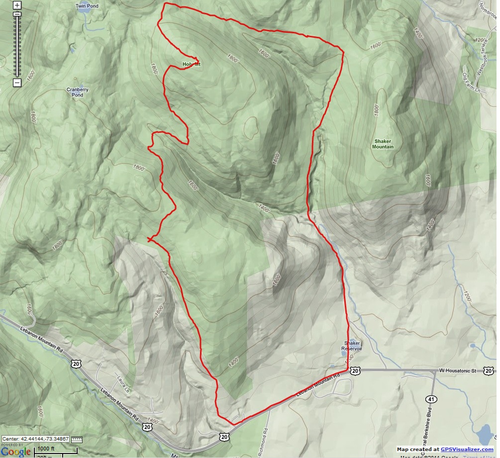
Trail Running 1:12:00 [3] 5.48 mi (13:08 / mi) +938ft 11:18 / mi
rhr:45
While running in Pittsfield State Forest the other day, I realized that I didn't have the topo map that covered the area I was in, so I made a note to pick one up, which I did a couple days ago. And, while looking it over, I noticed some trails starting at Shaker Village on Route 20, which actually lead into the Pittsfield S.F. within a short distance.
So today, I decided to check them out. I really didn't know that there was a Shaker Mountain, but, yes, it's there and evidently was used by the Shakers. The Village has some signage up, showing the reservoir used to supply the village, and a few other odds and ends, which I didn't bother to investigate today.
I just wanted to explore a loop that I thought was possible and even though the initial trail quickly deteriorated into a rutted, rocky mess, it was still mostly runnable--so I continued until I hit the trail heading west that I spotted on the USGS topo map. Eventually, I turned south and headed over Mt. Holly, another Shaker settlement area. Coming off Mt. Holly, I decided to expand the loop a bit, so I headed west, eventually hitting something called Brook Trail, although it was not on the topo. Finally came out on Route 20 a bit west of my car.
Certainly worth more exploration and I now know which route to take to get up to Mt. Holly, without having to use the crappy jeep trail. :-)
Thursday Dec 1, 2011 #
Walking 4:00:00 [3] 7.5 mi (32:00 / mi)
Hike with Bruce Shenker in the Catskills along the east-west running ridgeline that goes to Blackhead on the Escarpment Trail. Our hike was cut short a bit when both of the soles on Bruce's hiking boots decided that they had had enough of the hike and left in a huff. :-)
We had breakfast in Tannersville at a pricey hippie joint before hitting the hills.. Beautiful day with no clouds. The trails were surprisingly wet in the lower elevations, while there was a light dusting of snow higher up.
We had breakfast in Tannersville at a pricey hippie joint before hitting the hills.. Beautiful day with no clouds. The trails were surprisingly wet in the lower elevations, while there was a light dusting of snow higher up.
Wednesday Nov 30, 2011 #
Trail Running 48:29 [3] 4.25 mi (11:24 / mi)
Short recovery run in Kennedy Park starting at the Arcadian Shop, as I wanted to buy a topo map there. Pretty tired from yesterday's run. Tomorrow it will be a long hike with Bruce Shenker in the Catskills.
Tuesday Nov 29, 2011 #
Trail Running 1:31:08 [3] 7.35 mi (12:24 / mi) +1056ft 10:55 / mi
Started at New Lenox Road, at the northern end of October Mountain S.F., and ran down to Ashley Reservoir where I had to bushwhack a bit before picking up a jeep road. Managed to get into the mountain bike trails and much to my surprise, found that they had been raked clean! Those bikers are a bunch of wusses. :-)