Training Log Archive: PGIn the 7 days ending Nov 21, 2011:
| ||||||||||||||||||||||||||||||||||||||||
| « | » |
| » now | ||||||||||
| Tu | We | Th | Fr | Sa | Su | Mo | |||||||
Monday Nov 21, 2011 #
10 AM
mapping 4:35:02 [1] 4.77 mi (57:39 / mi) +781ft 49:55 / mi
Another day mapping. At least the weather has been good so I'm making progress, seem to be just over half done. So far I've put in 34 hours. Finish it in another 6 days of work? Wednesday is rain, Thursday in CT. But could have a major chunk done by the start of deer season on Monday if I can keep at it (meaning if my mind and/or body don't break down first).
Not my most productive day, had one nasty section, old sand pit, interesting contours but overgrown with a variety of thick vegetation. Not sure I mapped it well enough to be useful, but maybe.
There was one moment today when I said to myself, All of a sudden the base map has gone to hell, now what am I going to do. This was right on the edge of the old quarry. Of course a moment later I determined I was not where I thought I was.
The base map continues to be really excellent.
Sunday Nov 20, 2011 #
Event: NEOC: Blue Hills Traverse
8 AM
mapping 5:38:37 [1] 5.99 mi (56:32 / mi) +1056ft 48:26 / mi
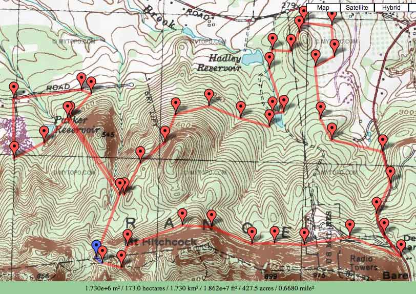
Still to do (1.7 sg km, if I do all the corners) --
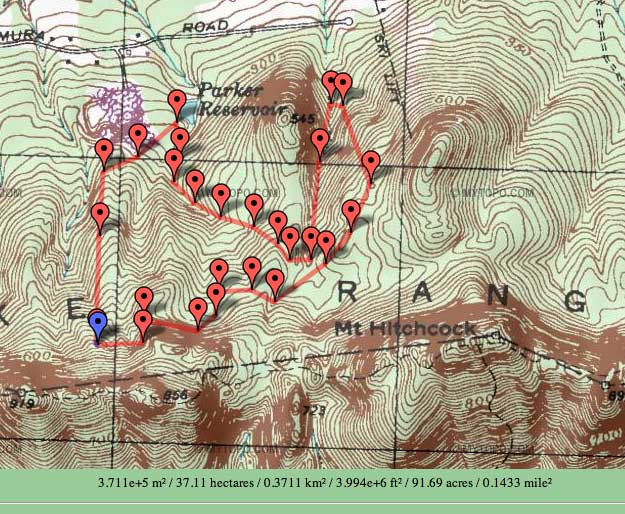
Or, to take the glass half full approach (or almosthalf full), what's done (1.4 sq km) --

Yesterday I got reminded of another thing coming soon, in addition to cold weather and snow -- deer hunting season starts a week from tomorrow. The reminder was a nice old beech tree, carved into which were a name, a date (from 1990), and "8 point buck." So got to keep at it. And try to get all the land that might be private done before than, since landowners might be out then. And wonder what I was doing.
I have been wearing a bright orange hat. Might have to add an orange jacket too.
I can't imagine doing this map from a USGS base. There's a lot more going on that the USGS indicates and the hillsides would be just impossible. Even a regular stereo base would be hard. Some steep slopes and lots of hemlocks.
Lots of bikers out today. Also some hikers up on the Seven Sisters trail, where there's actually some beautiful O' terrain, at least in the one section I'll be using. Nice day.
But I sure am tired. Plus still sick, though maybe getting better.
Glad I wasn't at the Traverse, doubt I would have finished.
Or, to take the glass half full approach (or almosthalf full), what's done (1.4 sq km) --
Yesterday I got reminded of another thing coming soon, in addition to cold weather and snow -- deer hunting season starts a week from tomorrow. The reminder was a nice old beech tree, carved into which were a name, a date (from 1990), and "8 point buck." So got to keep at it. And try to get all the land that might be private done before than, since landowners might be out then. And wonder what I was doing.
I have been wearing a bright orange hat. Might have to add an orange jacket too.
I can't imagine doing this map from a USGS base. There's a lot more going on that the USGS indicates and the hillsides would be just impossible. Even a regular stereo base would be hard. Some steep slopes and lots of hemlocks.
Lots of bikers out today. Also some hikers up on the Seven Sisters trail, where there's actually some beautiful O' terrain, at least in the one section I'll be using. Nice day.
But I sure am tired. Plus still sick, though maybe getting better.
Glad I wasn't at the Traverse, doubt I would have finished.
Saturday Nov 19, 2011 #
8 AM
mapping 7:10:00 [1] 7.0 mi (1:01:26 / mi) +1312ft 52:10 / mi
All day out in the woods. Took Gail's Garmin (mine is busted), only at some point it was off for a little over an hour, but still an interesting route.
Some gorgeous woods, some not (saplings), but should be very nice to have a map. If I can hang in there. Need to do a bunch of days like today and I am pretty worn out. Though I'm sure I'd feel better without a headache.
So my approach to whether to add points features to the map is generally to ask myself, Would I put a control there. And generally if the answer is yes then I add the feature, and if no, then leave it off. I don't know what other folks do. Yes, I know there are size standards, but there are also visibility considerations. Sometimes I'm thinking like a mapper, sometimes like a course setter, and I suppose also sometimes like a runner, the latter probably when mapping green.
Needless to say, it's not simple. I always thought mapping was great training for orienteering. It does take time. I don't know if many people do it these days.
Friday Nov 18, 2011 #
Note
Sure wish I could shake whatever it is I got from Gail, which she got in Turkey. She seems to be mostly better, I'm still feeling mostly crappy, though never (or at least not yet) anywhere near as bad as she was.
No mapping today, just back from the weekly trip to mom's and other things need doing, but need to get at it full-time starting tomorrow if I hope to get done this fall. Only so much good weather left.
Reminds me of when Swampfox made the original version of the adjacent terrain (Mt. Norwottuck / The Notch). He stayed with us. I think he arrived in December? I think he finished in May? A lot of off days due to snow. And in the meantime, we were subjected to some of the worst music I have ever heard. The things you will put up with to get an O' map made....
Thursday Nov 17, 2011 #
mapping 2:20:00 [1]
More mapping. I've decided that Eddie's basemap is positively brilliant.
Wednesday Nov 16, 2011 #
Note
Isn't Sammy and his various aliases something? So sure of himself, sees things in black and white, no shades of gray. I don't care for such, maybe because that's the way my father was....
And unaware of various things that are going on. And so his comments tend to be quite far off the mark.
I'd try to educate him a bit, but he's clearly not interested in such. And I'm not going to waste my time.
Plus, to me one of the real failures of the internet is the anonymity. I'm totally for free speech, but coming with it needs to be that you live with the consequences of what you say.
One of the nice things about AP is that you almost always know who the participants are. Too bad that can't be true 100% of the time.
Note
Here's the overall area to be mapped (right about 3 square km), click on images for a larger version --

And here's what I've done (about 0.5 square km) in about 13 hours.
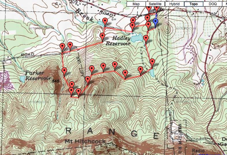
And here's what I've done (about 0.5 square km) in about 13 hours.
9 AM
mapping 3:05:00 [1]
At it again, before the rain came.
I'm guessing the whole thing will take me something between 50 and 100 hours, probably closer to the latter, if I continue at the pace I'm going. Not sure how I will manage, depends on the weather. Also I need to start putting in longer days when the weather is OK. I used to be able to do that, but that was 30+ years ago.
I'm also wondering what the final product will be like. My mapping experience, and therefore I expect my skills, is from an era that now seems to be regularly lambasted these days. What I think that means is that the old style didn't put enough details on the map, apparently not by a long shot, given how many details are stuffed onto maps these days. The fact the the maps are difficult, well, really way too difficult, to read doesn't seem to matter. Got to get all the stuff on there.
I remember when 1:10,000 maps first started being used. I'm pretty sure the initial impetus was to make maps easier to read for older folks. It wasn't long before 10K maps were just as hard to read as 15K ones. The same thing has happened with the 5K maps for sprints. Look at the line widths and the spacing. Can be very very hard to read. So lots of folks, and that includes younger folks, use magnifiers of one sort or another. Not sure what that does for the image of our sport, but can't imagine it is good.
But we love our maps. And we love them complicated. So what if they represent a barrier to entry for newcomers. Which I am quite sure they do.
So anyway, I'll make this map the way I know how. And see what happens. If it's considered to be undermapped, then so be it.
Of course, that's assuming I can actually get it done. Just been doing field work so far. OCAD is another matter. I think I am too old for it. But I'm hoping to get it done before spring, would be nice to have another place to train around here, and this area has lots of hills, lots of trails, mostly good woods, and hardly any rock. Sounds like some of the Swiss terrain.
Tuesday Nov 15, 2011 #
mapping 3:00:00 [1]
Some more mapping, making a little progress but a long long way to go. A few sprinkles, never anything more, though I called home at one point to see what the radar looked like.
Saw a woodcock, first one in a long time. Flush it right in front of me at the edge of a field, couldn't had a better look at it (or shot, if I'd been out there for that).
And then just enough daylight for a round of golf, first in several weeks. Very enjoyable, except that I felt increasingly crappy as the afternoon went on. I thought I was well on Sunday, but it's been all downhill since then. Yikes.