Training Log Archive: iansmithIn the 7 days ending Jun 20, 2010:
| |||||||||||||||||||||||||||||||||||||||||||||||||||||||||||||||||||||||||||||||
| « | » |
| » now | |||||||||||||
| Mo | Tu | We | Th | Fr | Sa | Su | ||||||||||
Sunday Jun 20, 2010 #
Note
Orienteering 1:23:59 [4] *** 9.2 km (9:08 / km)
10c shoes: 201004 Inov8 X-Talon 212
I had some difficulty mentally focusing on the objective while I was running. Particularly in an area as technical as Pawtuckaway, lack of focus prohibits accurate execution. I blundered on control 1, deviating from my plan to attack down the reentrant and marsh. I relocated off the water course south of the control, then saw the feature from near the marsh. I saw Lori, Presto, and Alex as I was leaving the control.
The first part of the leg to control 2 required skirting the edge of a large swamp inlet over heavily contoured, rugged ground. I made the traverse, though not quickly, and attacked the control from a pond to the ridge and down into the reentrant. I should have planned that, because the ridge was a very prominent, visible feature, but my plan was more direct, and again, I did not execute it. Borrowing from Ali and Lori's discussion, I planned the most reliable route to 3 that I saw - I ran along the trail to a wall, then followed the wall to a junction very near the flag. I was clean, though the climb along the wall was arduous.
I seem to have difficulty counting under race conditions, or I am too ready to discard my recollection of the route in favor of local observations. The route to Control 4 made extensive use of linear features; I followed three large, parallel cliffs down a reentrant. However, after passing the second cliff, I saw a swamp - which I thought was after the third. So, I presumed I had hit the third cliff, and proceeded to attack up the hill. Beyond the hill, I saw the *actual* swamp, and had to rectify my error. The climb up the hill to 4 was more severe than the map suggested. I ran into Katia on this leg.
I executed correctly on the rest of my legs, though I was moving sluggishly in the heat and given the deer flies. I hesitated for some time on the way to control 9. After the rock wall left of the line, I hit a swamp, and I couldn't decide if it was the large, green swamp that I wanted on my right or the smaller one that should have been to my left. I eventually figured it out (it was the former), and completed my assault on the control; I had passed Alex earlier on the leg, but caught her ahead of me after my blunder.
At 11, I had trouble lining up the features on the map to those around me near the circle. I did arrive at a boulder with a small streamer adjacent to it; I decided to confirm it was the correct location, and checked some nearby features. Control 12 was uneventful, if slow; I waited for Alex and we rehung the streamer.
Orienteering 54:04 [4] 6.05 km (8:56 / km)
shoes: 201004 Inov8 X-Talon 212
One aspect of the exercise I really appreciated was the requirement to build a complete mental picture. Ordinarily, when you can look at your map whenever you want, it is possible to build a plan without considering all the relevant information. Since that information is available at a glance, there isn't as much impetus to complete the mental image, and so information is discarded. With a memorization exercise, you must complete the image - the route, catching features, check points, the control feature, distance, direction, and so on. Some parts were very challenging for me - memorizing a leg while running and following along, remembering all the detail and important information and figuring out how to simplify without forgetting too much to run the leg.
Ross graciously didn't push too hard for me to keep up, and we made good time. It felt somewhat cooler than it had in the morning, and the deer flies troubled me less - whether because I had adjusted, because there were two meals instead of one, or because they were less active. Having a running buddy to discuss routes, problems, and to enjoy the woods also made this a more pleasant run than the morning.
Running 15:00 [1] 2.5 km (6:00 / km)
shoes: 201004 Inov8 X-Talon 212
Saturday Jun 19, 2010 #
Note
(rest day)
I think it would be fascinating to have a conversation with the Ian from the day I die. Assuming he still had his mental faculties, imagine the perspective he would bring to the actions and trends of my life. It would offer something resembling a global optimal perspective on my local decisions. What would probably be more accurate and less susceptible to small deviations in Ian's attitude and reflections would be a community algorithm in which the distribution of Ians over the course of my life were sampled for their reactions to individual actions in hindsight. I am curious to see how the next (say 60 or quite possibly 80) years will affect my thinking and attitudes. What will I know then that I do not understand now? What will I care about? How will I meet my end? Of course this thought experiment would be useless if my death should come tomorrow from a Fedex truck or a tragic bowling accident.
In Star Trek II, Kirk is forced to face death as Spock sacrifices himself. The line "how we face death is at least as important as how we face life" sums up one of the themes of the movie. The reminder of our own mortality, of our finiteness presents a context for the actions and events in our lives. Of course, we could go our lives only confronting death at the infrequent instances when a loved one - friend, relative or pet - is taken from us. Or, as Picard says in Star Trek VII: "Someone once told me that time was a predator that stalked us all our lives. I rather believe that time is a companion who goes with us on the journey and reminds us to cherish every moment, because it will never come again. What we leave behind is not as important as how we've lived. After all Number One, we're only mortal."
Star Trek, at its best, was a significant philosophical influence in my early life.
Biking 33:20 [2] 10.69 km (19.2 kph)
shoes: Trek 7.1 FX
Riding along the river was very pleasant, and I was moving at full speed for much of the trip. Traffic lights, unexpected turns, and inattentive pedestrians slowed me down, but I managed to achieve a top speed of about 30 kph.
Biking 21:55 [2] 8.85 km (24.2 kph)
shoes: Trek 7.1 FX
Friday Jun 18, 2010 #
Note
http://www.youtube.com/watch?v=2sD_8prYOxo&feature...
I went to Sears' today to purchase socks and shorts. At the checkout counter, the cashier gave me the usual spiel - asking me if I wanted a credit card, special offers and so on. She lacked enthusiasm; she was worn out and was probably just doing what was necessary to make it to the end of her shift. I wonder what her hopes and dreams are, what she ponders, and how she will look back on her life near the end. I wonder if she spends any time reflecting on her life, on her condition, wondering about the nature of things. I wonder if she is happy. Are she and I so different?
Running 44:15 [2] 8.33 km (5:19 / km)
shoes: 201003 Nike Lunarlite
I continued The Desert Spear, though I found several sections gratuitous, repugnant, and unpleasant. I need to get new insoles for my current Asics running shoes so I can stop using my track shoes for general training.
Curiously, my chest, shoulders, and abs hurt, I suspect from a combination of the supplementary strength training I have done over the past few days and from the hard intensity of intervals and racing. Perhaps my heart rate strap can give me some support.
Thursday Jun 17, 2010 #
Running 10:40 [2] 2.27 km (4:42 / km)
shoes: 201003 Nike Lunarlite
Running race 5:21 [5] 1.0 mi (5:21 / mi)
shoes: 201003 Nike Lunarlite
200m splits:
39.4 (209m)
40.2
42.1
42.0
41.0
41.9
39.6
34.5
Picture, courtesy of Tim Parson; click for a larger version:
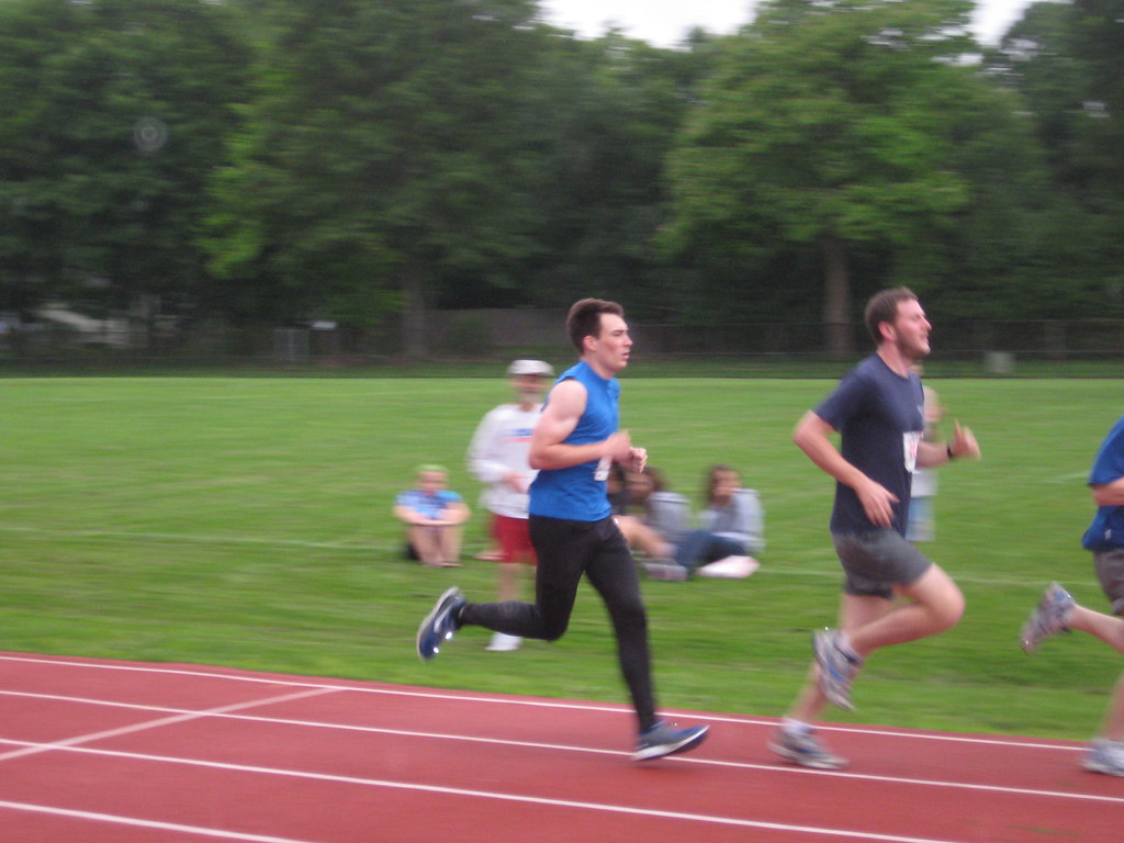
The results say that I finished in 5:25.81, but I'm quite sure that's incorrect - I saw the clock as I passed the finish line. I think it likely that they accidentally permuted the finishing order. I passed a pack of runners in the last 200, so I suspect I was the 5:20:48 runner. Congratulations to Ross, Alex, Bill, and Tim, all of whom had fine showings.
Orienteering 42:12 [3] 6.34 km (6:39 / km) +44m 6:26 / km
Wednesday Jun 16, 2010 #
Note
The obvious question both of this approach to challenges and of early schooling in general is to what end you are preparing. Strength is useless without purpose; the reason to build strength is to achieve some objective. That objective may be simply surviving the obstacles of life or accomplishing some great deed. Perhaps it is enough to pursue life seeking happiness, enriching the lives of and loving others and in turn being enriched by them, solving problems, and righting wrongs and injustices. Maybe maximizing our global utility function is a good objective, a valid purpose for our preparation and existence. Seeking a righteous life raises questions about the nature of our moral code; I will share a summary of my thoughts in a later entry.
In the interim, perhaps bereft of a well-defined goal, I will continue to aspire to strength.
Note
Passion is inversely proportional to the amount of real information available.
Clearly, I need to read Timescape.
Running 28:30 [1] 5.45 km (5:14 / km)
My lower right calf intermittently twinges with pain. It is a bit higher than my Achilles' tendon, but I am concerned there may be a serious problem. My training regimen has not been severe in the past 8 weeks (about when the problem started), so I don't think rest and ice will have much effect. I may see my doctor about it if it continues. On an entirely unrelated note, I'm running a mile race tomorrow. Yay prudence.
I finished the session with a stop at a playground, where I did 20 pullups, 50 crunches, and 24 pushups.
Tuesday Jun 15, 2010 #
Running 18:24 [1] 3.36 km (5:29 / km)
shoes: 201003 Nike Lunarlite
Running intervals 30:33 6.8 km (4:30 / km)
shoes: 201003 Nike Lunarlite
Splits / 200 m rest time
400 m: 1:20.8 / 1:15.7
600 m: 2:05.0 / 1:36.5
800 m: 2:54.0 / 1:21.3
1000m: 3:44.4 / 1:26.4
800 m: 2:44.9 / 2:00.9 (Ross was chasing; I pushed hard)
600 m: 2:30.1 / 1:22.1
400 m: 1:26.9 / 1:40.1
800m magic: 3:04.2
Strength training 10:00 [3]
1 minute: plank
2x1 minute: crunches with one foot raised to the opposite knee, reverse;
2x1 minute: side plank, each side
1 minute: flutterkicking
2x1 minute: oblique crunches, with knees rotated to one side, reverse;
1 minute: back plank
1 minute: Superman
Running 21:14 [1] 3.55 km (5:59 / km)
shoes: 201003 Nike Lunarlite
Monday Jun 14, 2010 #
Running 34:11 [1] 6.75 km (5:04 / km)
shoes: 201003 Nike Lunarlite