Training Log Archive: NadimIn the 7 days ending Aug 6, 2021:
| |||||||||||||||||||||||||||||||||||||||||||||||||||||||||||||||||||||||||||||||||||||||||||||||||||||||||
| « | » |
| » now | ||||||||||||||
| Sa | Su | Mo | Tu | We | Th | Fr | |||||||||||
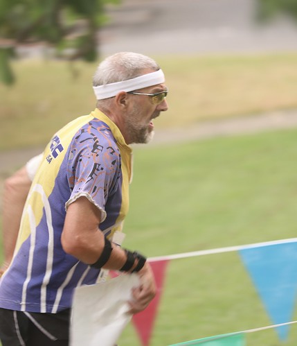
Friday Aug 6, 2021 #
Orienteering (Foot) 16:20 [3] 2.4 km (6:48 / km) +35m 6:21 / km
(injured)
S-1 - I moved okay and spiked it. The 1:3,000 map helped! I wasn't thrown off by the distances.
1-2 - I went up what seemed to be the main corridor. With the excitement, I lost track of exactly where I was. An unmapped double railing on one sidewalk confused me. However, I recognized the diagonal sidewalk in time to cut right at the right time, and move on to spike the control.
2-3 - I chose to take the southern route, but in retrospect, some seconds might have been saved going around to the left/west side of the pool. I still spiked the control.
3-4 - Straight.
4-5 - Through the canopy, then across the parking lot, to approach the control from the south. I had read the clue to be underneath and went right to it.
5-6 - Straight, but hesitantly.
6-7 - I went counter-clockwise around the first building, then clockwise around the next. I spiked it. Joe Barret had passed me after the stairs.
7-8 - With 3 main routes, my execution of going north, south, then north again was probably not optimal. I got to the ramp before the control from the east. However, I lost not time getting mixed-up on where I was.
8-9 - I went clockwise around the construction and approached the control from the north. This may not have been optimal but it seemed to reduce climb and was not hard to execute.
9-10 - While flipping the map about I think I got confused between controls 6 and 9. I ran north then east and got stopped by construction fencing. Going around that, I got into the main campus corridor before turning around. After that and relocating, I hit the control just fine. Based on my GPS track, I estimate losing at least 90 seconds. Winsplits had me in first place in my age group up until this control.
10-11 - I went back the way I'd come, between the large and small buildings. Going through the start was an option I didn't see but I don't think I'd have saved any time doing that.
11-12 - Around the building, being sure not to step in the gardens.
12-F - Pushing okay into the finish.
I got 4th overall in my age group. I think everyone in M60+ made some errors but I stood a good chance of placing without my error on the way to #10. That was surprising since I'd been injured and not training well since March.

Orienteering (Foot) 30:53 [2] 1.17 mi (26:24 / mi) +81m 21:44 / mi
(injured)

Thursday Aug 5, 2021 #
Hiking (Street & Trail) 15:00 [1] 0.3 mi (49:59 / mi)
(injured) (rest day)

We could see the plums from the Dixie fire. Eddie Bergeron had put together an interesting video from the GOES satellite imagery showing it from above.
https://i.imgur.com/Rv9yLX1.mp4
Swimming (Pool) 20:00 [2]
(injured) (rest day)
Wednesday Aug 4, 2021 #
Hiking (Trail) 1:43:54 [3] 3.71 mi (28:00 / mi) +124m 25:22 / mi
(injured)
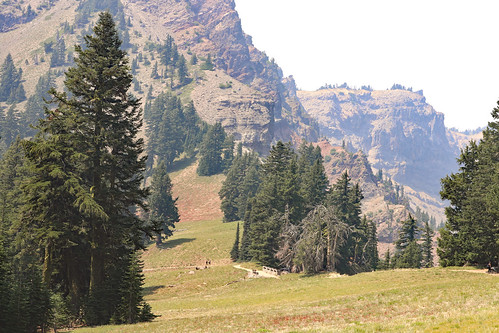
We hiked a trail to get close to an old Cinder Cone and went past the Fantastic Lava Beds on our left to get there. On our right was some very open pine forest that would be good for orienteering. Our progress hiking was slow, but with enough breaks for Samantha, we made it. The smoky and dark sky was fitting for seeing the cinder cone. Had we had more time, Max and I might have gone up it 700 ft. in a half mile. It was start and had a few trees growing on it. From where we were, we got some smoke obscured glimpses of the famed Painted Sand Dunes (what seemed to be rhyolite-like formations) from the eruption which happened only around the year 1650. Max and I went a little further than Samantha and Peggy; just past the saddle, to see the other side of the cinder cone. An earlier hiker had left 10 pine cones on the trail and in the cinder sand, had them inside a rectangle made by dragging a foot. This was a bowling alley. Max and I used small rocks to knock them down. We reset the lane before we left. Our hike back was fast. It was gently downhill and were trying to catch-up with Peggy and Samantha. Our walking fast became competitive, with Max edging me out at the end. Of course, he wasn't carrying my 20 lbs. of camera gear. :)


Running 23:32 [3] 2.07 mi (11:22 / mi) +21m 11:02 / mi
(injured)

Tuesday Aug 3, 2021 #
Hiking (Trail) 1:57:50 [3] 3.87 mi (30:27 / mi) +325m 24:09 / mi


Hiking 39:34 [3] 0.99 mi (39:58 / mi) +53m 34:19 / mi
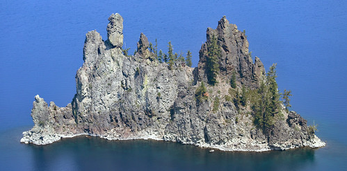
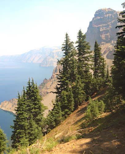
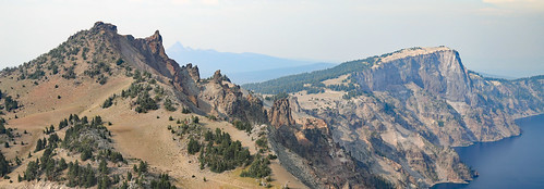
After the Garfield Peak hike, we drove on Rim Drive for a few stops. We saw Phantom Ship from the east and Vidae Falls which is right on Rim Drive. Our anticipated stop and short hike to Pinnacles was not to be since road construction had closed access :( --another time I hope.
From Rim Drive, our family took our last hike in the park. We hiked the short Sun Notch loop trail. What it lacked in distance, it made-up for with great scenery (despite the smoky air). Flowers, cliffs, Crater Lake and Phantom Ship (from the southwest) were prominent. Samantha was fussy again. I waked her up the trail, and Peggy walked he down. It was sad leaving but we had a lot of driving left for the day.
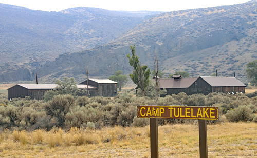
After a bit of driving, we made it to Tulelake, CA, where Japanese Americans had been interned during WWII. It was closed but the information sign outside was right on target spelling out how the Constitution is just a piece of paper unless people back it up--a lesson to keep in mind more than ever today.
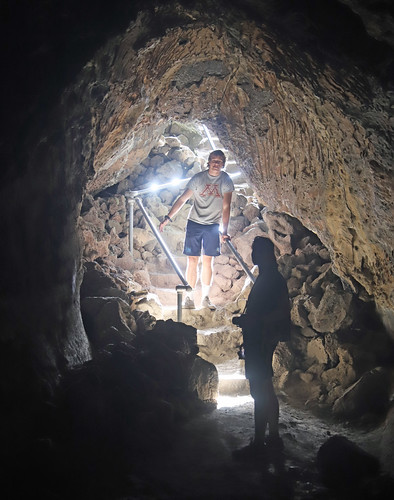
Afterwards we got to Lava Beds National Monument. The visitor center was closed but we did get to do a few short hikes through the natural bridges and lava tube caves off of Cave Loop Road--fun!

To finish the day, we had another 150 miles of driving to get to Redding, CA--about 15 of that was on a windy bumpy dirt road and another 30 was on a narrow and bumpy paved road. We had late pasta dinner at a local pizza joint before crashing.
Monday Aug 2, 2021 #
Hiking (Trail) 31:47 [3] 0.5 mi (1:03:32 / mi) +10m 59:49 / mi

Hiking 22:31 [3] 0.79 mi (28:31 / mi) +16m 26:50 / mi
Hiking 1:20:23 [3] 2.0 mi (40:11 / mi) +121m 33:50 / mi
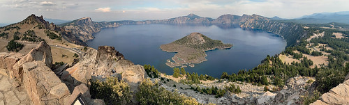

Wizard Island with it's eye catching cone was close and almost below us. White dead trees on the top resembled standing skeleton bones.


Sunday Aug 1, 2021 #
Rowing (Sea Kayaking) 1:27:09 [3] 3.33 mi (26:10 / mi)

Kayaking Video (short)

Kayaking Video (long)

Hiking (Trail) 23:52 [3] 0.58 mi (41:10 / mi) +18m 37:37 / mi


Hiking (Terrain) 13:18 [3] 0.28 mi (47:28 / mi) +10m 42:38 / mi
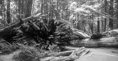
It wasn't obvious where to stop. The Visitor Center was halfway into the drive. I pulled over randomly at one pull-off. Max, Peggy and I explored the Pioneer Grove and there wasn't much of a trail there.

Hiking (Trail) 44:00 [3] 1.0 mi (44:01 / mi)

Hiking (Trail) 39:42 [3] 1.8 mi (22:03 / mi) +30m 20:58 / mi


We also spent a few minutes in Elk Praire and saw a few elk.

Saturday Jul 31, 2021 #
Bicycling (Tandem) 1:31:51 [3] 10.35 mi (8:52 / mi) +136m 8:32 / mi


Hiking (Trail) 1:24:20 [3] 3.02 mi (27:56 / mi) +44m 26:43 / mi

