Discussion: I need to go look at my map
in: Doris; Doris > 2017-11-19
Nov 21, 2017 7:40 PM
#
Apparently 11 and to a lesser extent 12 were what gave Tom Nolan trouble but my map memory isn't up to telling me exactly where in the course that was, at least not any better than I can guess from it being 14 that one could shortcut to the finish from.
Nov 22, 2017 4:01 PM
#
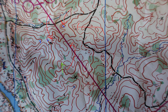
Having my map in front of me now, 11 to 12, about the center point is a hilltop of exceedingly complex shape containing a couple of simpler formline hilltops within it. The closed contours are, in Mid-Atlantic terrain, just about guaranteed to be the upper parts of hills (go to karst or the kind of glacial terrain characterized by depressions of various sizes everywhere and life gets more complicated, with corresponding routine use of slope tags on the large depressions and sometimes also in reentrants) though the fact that that area is almost surrounded by the C&O canal to the SW, the small stream just north of the trail to the north, and the somewhat larger stream to the ESE is probably at least as important a factor in revealing what is up and down generally in that area.
Now that I look more closely, there's something quite unusual going on with the formlines inside the SW part of that squiggly hilltop - it looks as though half of a formline hill is mapped, with a slope tag indicating the downhill side rather than closing the contour. Presumably the mapper thought a full formline hilltop would give the impression of steeper terrain than actually existed.
There's also a clear violation of the rule against stacking formlines, with the formline hilltop clipped by the line from 11 to 12 and then just to the SE another formline clearly indicating some shallow reentrants at slightly lower elevation.
Isn't geeking out over contours fun? Regardless, that area is legitimately confusing in the more subtle details, though the big picture of what is up and down is clear enough if one simplifies successfully.
Nov 22, 2017 4:20 PM
#
So all those closed loops (red arrows) are the tops of hills? They can't be depressions? Are the dark contour lines all the same height (three blue xs)? And the green arrow tells me that that is downhill if I'm walking from SW to NE?
I have no idea what you are saying about the stacking violation. :)
I have no idea what you are saying about the stacking violation. :)
This discussion thread is closed.