Training Log Archive: BashIn the 7 days ending Oct 6, 2013:
| ||||||||||||||||||||||||||||||||||||||||||||||||||||||||||||||||||
| « | » |
| » now | ||||||||||
| Mo | Tu | We | Th | Fr | Sa | Su | |||||||
Sunday Oct 6, 2013 #
9 AM
Trekking (Trail) 2:00:00 [2] 8.0 km (15:00 / km) +269m 12:50 / km
shoes: Salomon SLAB-3 XT Wings
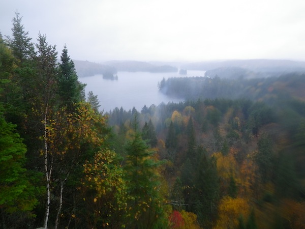
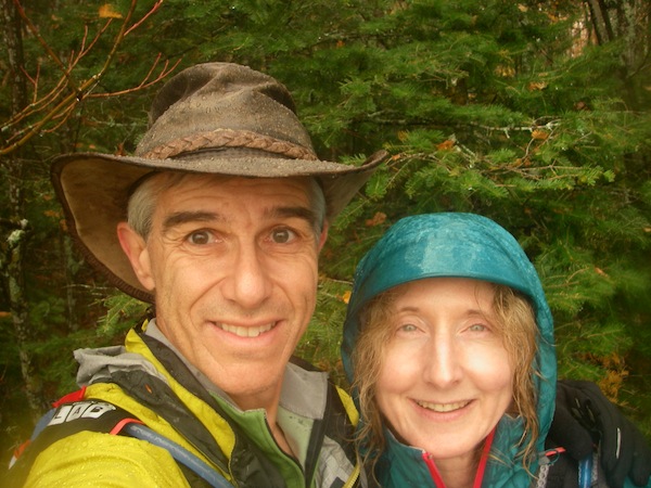
It was pouring rain this morning, and the big fireplace in the lodge was awfully nice but we couldn't waste our last morning in Algonquin Park. We usually run the nearby Mizzy Lake Trail but I'm not allowed to run that far so we hiked the Track and Tower Trail, which we'd never done before. We'll definitely be doing it again! The scenery is excellent, particularly in autumn, and the lookout is one of the best views in Algonquin Park. There is even a big set of stairs where we could do repeats if we were feeling really keen.


This ended up being another historical outing. The interpretive guide pointed out all sorts of evidence of human activity. The Cache Lake area was once the bustling centre of Algonquin Park. It's impressive and encouraging to see how nature has taken over. We were walking on a lovely, leaf-covered ridge trail in the forest when we arrived at a numbered post. I checked the guide and discovered that we were walking on the old rail bed of what was formerly the busiest rail line in Canada. Wow!
I felt good for awhile and ran the short distance where we overlapped the bike rail trail. By the end, though, my heel was on fire. Too bad since it seemed to be improving with the laser treatment and rest. :((
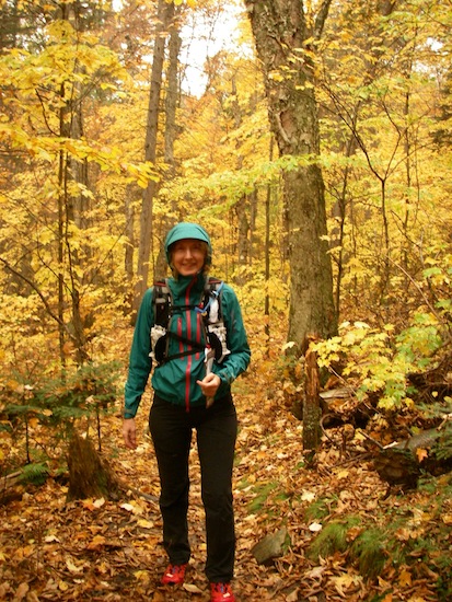
With the steady rain, a lot of my photos ended up blurry because of droplets of water on the lens.


This ended up being another historical outing. The interpretive guide pointed out all sorts of evidence of human activity. The Cache Lake area was once the bustling centre of Algonquin Park. It's impressive and encouraging to see how nature has taken over. We were walking on a lovely, leaf-covered ridge trail in the forest when we arrived at a numbered post. I checked the guide and discovered that we were walking on the old rail bed of what was formerly the busiest rail line in Canada. Wow!
I felt good for awhile and ran the short distance where we overlapped the bike rail trail. By the end, though, my heel was on fire. Too bad since it seemed to be improving with the laser treatment and rest. :((
With the steady rain, a lot of my photos ended up blurry because of droplets of water on the lens.
Saturday Oct 5, 2013 #
9 AM
Mountain Biking (Trail) 1:49:00 33.2 km (18.3 kph)
'Bent's GPS track (I forgot mine): http://www.attackpoint.org/sessiondata.jsp?session...
'Bent and I rode the Old Railway Bike Trail from Lake of Two Rivers Store to its western terminus, then went east to explore the Pog Lake campground, which was much prettier than its name suggests, and back to the car.


We detoured to ride the Cache Lake Dam service road, which involved some steep climbing on a soft surface but was worth it for the autumn scenery. Confession: There was a "No Hiking" sign that probably implied bikes were prohibited too but it was hard to resist exploring such a pretty road.


We were cruising along at a good pace when a bull moose rose out of the wetland and stepped onto the trail about 10 m in front of us, blocking it sideways. We threw on our brakes and sat wide-eyed. He stood there for a few seconds while he made up his mind, then he started trotting away from us down the trail.
'Bent started riding in hopes of getting a better photo.
Me (in a loud whisper): "Stop!!!! Remember Survivorman saying that a bull moose is the most dangerous animal in the Ontario forest?"
'Bent: "That's only in one particular season."
Me: "Yes. THIS season!"
He didn't believe me (until Google backed me up later) but luckily he stopped and took a "that big speck is a moose" photo.

We chatted with some New Zealanders back at the lodge, and they were quite envious. In their vision of Canada, I'm sure cyclists constantly fend off moose, bear and lynx!

'Bent and I rode the Old Railway Bike Trail from Lake of Two Rivers Store to its western terminus, then went east to explore the Pog Lake campground, which was much prettier than its name suggests, and back to the car.
We detoured to ride the Cache Lake Dam service road, which involved some steep climbing on a soft surface but was worth it for the autumn scenery. Confession: There was a "No Hiking" sign that probably implied bikes were prohibited too but it was hard to resist exploring such a pretty road.
We were cruising along at a good pace when a bull moose rose out of the wetland and stepped onto the trail about 10 m in front of us, blocking it sideways. We threw on our brakes and sat wide-eyed. He stood there for a few seconds while he made up his mind, then he started trotting away from us down the trail.
'Bent started riding in hopes of getting a better photo.
Me (in a loud whisper): "Stop!!!! Remember Survivorman saying that a bull moose is the most dangerous animal in the Ontario forest?"
'Bent: "That's only in one particular season."
Me: "Yes. THIS season!"
He didn't believe me (until Google backed me up later) but luckily he stopped and took a "that big speck is a moose" photo.
We chatted with some New Zealanders back at the lodge, and they were quite envious. In their vision of Canada, I'm sure cyclists constantly fend off moose, bear and lynx!
3 PM
Paddling (Canoe) 1:30:00 [2] 7.84 km (5.2 kph)
After about 8,000 calories at the delicious Arowhon Pines lunch buffet, 'Bent and I waddled down to the waterfront and went for a paddle to the south end of Joe Lake. We passed Gibraltar Rock where we were married but it is such a nice campsite that we rarely get to visit; it was occupied again this year. One of the other lodge guests said that hotel staff told her it was called "Wedding Rock". I guess we've made our small mark on the world. :)

I've been reading a book about the history of the settlements of Joe Lake and Canoe Lake, which were a few kilometers - and one train station - apart near the south end of Joe Lake and north end of Canoe Lake respectively. The book's author was a park ranger's daughter who grew up in Joe Lake between 1928 and the mid-1940s. She included hand-drawn maps of the settlement showing the locations of residents' cabins, Hotel Algonquin, Colson's Store, etc. I'd hoped we might find some foundations but when the Ontario government wants to destroy all evidence of a building, they do a great job.
We think we found the sites of the store and the hotel, both of which are now used mostly as parking lots for leaseholders, and we definitely found the location of the author's cabin, which was burnt to the ground by the government. Amongst other things, we found a half-buried metal bed frame in a flat section of forest in the right location. She mentioned that bed frame near the end of the book when she talked about returning to the site in later years. Cool! It's impressive to see how completely the forest takes over if you give it 60 or 70 years.

When we started paddling again, a long crack opened up in the bottom of the canoe and started flexing. It didn't go all the way through but it wouldn't take much for that to happen, and some water started pooling in the bottom of the boat. We paddled directly back to the lodge, following the shoreline and singing, "Near far, wherever you are..." No, not really! :)
I didn't turn my GPS on and off at all the right times but this is close.
I've been reading a book about the history of the settlements of Joe Lake and Canoe Lake, which were a few kilometers - and one train station - apart near the south end of Joe Lake and north end of Canoe Lake respectively. The book's author was a park ranger's daughter who grew up in Joe Lake between 1928 and the mid-1940s. She included hand-drawn maps of the settlement showing the locations of residents' cabins, Hotel Algonquin, Colson's Store, etc. I'd hoped we might find some foundations but when the Ontario government wants to destroy all evidence of a building, they do a great job.
We think we found the sites of the store and the hotel, both of which are now used mostly as parking lots for leaseholders, and we definitely found the location of the author's cabin, which was burnt to the ground by the government. Amongst other things, we found a half-buried metal bed frame in a flat section of forest in the right location. She mentioned that bed frame near the end of the book when she talked about returning to the site in later years. Cool! It's impressive to see how completely the forest takes over if you give it 60 or 70 years.
When we started paddling again, a long crack opened up in the bottom of the canoe and started flexing. It didn't go all the way through but it wouldn't take much for that to happen, and some water started pooling in the bottom of the boat. We paddled directly back to the lodge, following the shoreline and singing, "Near far, wherever you are..." No, not really! :)
I didn't turn my GPS on and off at all the right times but this is close.
Friday Oct 4, 2013 #
Note
Hi ho, hi ho, it's off to Algonquin Park I go... :)
Note
It was a beautiful drive north since the autumn leaves were at their peak in the Gravenhurst-Huntsville area. The sugar maples in Algonquin Park peaked last Tuesday, then high winds blew down a lot of the leaves in the canopy. It was still spectacular since the poplars and birches were near their colour peak, a few nice maples still had leaves, and the ground was covered with multi-coloured leaves.
We are so lucky to live in a place where we get to see this for several weeks every year. We met a number of foreign tourists who were as excited as I get when I see aurora borealis.

We are so lucky to live in a place where we get to see this for several weeks every year. We met a number of foreign tourists who were as excited as I get when I see aurora borealis.
Thursday Oct 3, 2013 #
Note
In case you didn't see it on Facebook, this is pure gold: Luis, Joel and Los Dobos showing us how Breathe Magazine is made.
Wednesday Oct 2, 2013 #
Note
Mind blowing fact 'Bent learned from a conservation area superintendent today... Following a recent obstacle race on their property, he estimates that participants threw out approximately 3,000 pairs of shoes - because they were dirty, I suppose? He felt so bad about it after last year's event that he set up a shoe collection for charity and got 1,000 pairs this time. But there were still 3,000 pairs in the garbage! I guess these must be the one-timers since the serious obstacle racers choose good shoes, and they know how to clean them!
2 PM
Note

4 PM
Mountain Biking (Single Track) 1:12:17 16.35 km (13.6 kph) +251m
ahr:122 max:169
After a few days of rest, ice, laser treatment, prep for orthotics and a little disappointment, I've come to terms with the fact that I'd be stupid to try another ultra in 2013. I hate to finish the year with the DNF at UTMB but getting healthy is more important so I will look ahead to 2014.
It's been awhile since I wore a heart rate monitor for mountain biking since I haven't been analytical about my bike training. I wore it today to see how my HR looks for a typical single track ride at Albion Hills. There are moments of hard work uphill but a lot more coasting than when I run so I can't push the average HR as high as for running, which is typical for most people.
It was a relatively easy ride but I wouldn't want to go a whole lot faster right now with leaves hiding the trail surface and the occasional fallen tree across the trail. It was an absolutely gorgeous, warm fall day. Although I tried to avoid it, I rode through a section with poison ivy and had to scrub my tires with soap again. While I was doing that, a mosquito bit me. In October! Sounds like everyone has been seeing them lately.
Used bike computer distance of 16.35 km vs. GPS distance of 15.45. That's pretty close for single track.
Tuesday Oct 1, 2013 #
Note
I'm turning on the injury flag to remind myself why I took off 3 days in a row. I saw a chiropodist today who agrees that I have a gimpy left foot with a few bad things going on. Until the inflammation subsides, I'm allowed to hike with a heel lift and even run (on a reduced schedule). She feels it is good to maintain the activities to which my muscles have become accustomed but I'm not going to push it. No specific stretching or strengthening until after things have calmed down but it's OK to do yoga if I don't push too hard in the foot stretches. Laser treatment today. Let's see what happens.
7 PM
Note
A last minute opportunity! For the past month, the Middle and Long distance events at the 2013 Orienteering Nationals in Hamilton have been sold out. Because of some injuries and work commitments, a few participants have been forced to drop out of the event. I have re-opened registration for the sold-out races but availability is extremely limited because the Conservation Authority asks us to respect a maximum participation limit for environmental reasons.
So if you are looking for some activity to balance out the turkey calories on Thanksgiving weekend (Canadian, that is), there is a Sprint at McMaster late on Friday afternoon (Oct. 11), a Middle distance race on Saturday morning and a Long distance race on Sunday morning.
For adventure racers looking to do just one race, I'd suggest the Long distance on Sunday, which will give you a physical and navigational workout that is well worth the drive. It's always interesting to see where you stand at the Canadian orienteering championship, and it will be great training for Salomon Raid The Hammer since the championship events are also in the Dundas Valley.
The info is here, and you can click on the Registration tab to register online - but only until midnight tonight (or earlier, if it sells out again).
http://dontgetlost.ca/index.php?option=com_content...
Monday Sep 30, 2013 #
Note
Interesting news on the Candian ultra scene: The Sinister 7 Ultra in Alberta has been upgraded to a 100-miler for 2014.
http://www.sinister7.com/course.php
http://www.sinister7.com/course.php