Training Log Archive: BashIn the 7 days ending Nov 29, 2009:
| ||||||||||||||||||||||||||||||||||||||||||||||||||||||||||||||||||
| « | » |
| » now | ||||||||||
| Mo | Tu | We | Th | Fr | Sa | Su | |||||||
Sunday Nov 29, 2009 #
Trekking (Elapsed - 3:10) 2:30:00 [2] ** 11.2 km (13:24 / km)
shoes: Salomon XA Pros - Tomato
Grand Canyon Rim to Phantom Ranch via the South Kaibab Trail. (Time discounted for photography.)
When we headed to the mule corral this morning, we couldn't help noticing a slight change in the weather!

After a detailed pre-mule briefing from the wrangler, Dad and the other riders headed down Bright Angel Trail.
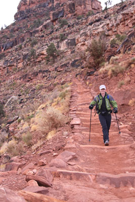
'Bent and I took the shuttle bus to the South Kaibab trailhead. It's 400' higher (7200' instead of 6800') and there was a good ol' snowstorm blowing by the time we were dropped off. (Sniff - I miss snow.) I'm used to the weather getting colder as I hike (usually uphill), but the hike into the Canyon is the other way around, getting milder as you go lower. It felt weird starting down the trail with a pack that seemed too light for the weather conditions.

We used trekking poles to save our knees during the 4,900' vertical descent - and to prevent us from slipping off a cliff. We thought about Urthbuoy portaging his kayak down this trail!

As we got lower, the snow turned into cold rain, and we got below the main clouds into better visibility. The South Kaibab is very exposed, which makes for spectacular scenery.
I got at least a dozen rainbow pics when the sun started to emerge - wide angle lens, telephoto, polarizer, no polarizer, yada yada.

The reason I had so much time for photography was that 'Bent dropped his sunglasses somewhere on the trail and disappeared uphill for a 15-minute exploratory tour. Sadly, he was unsuccessful - and I got chilled.
The weather kept improving and so did the views.

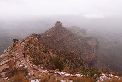
This photo shows the Colorado River with the treed valley of Bright Angel Creek heading north. That's where Phantom Ranch and Bright Angel Campground are located. I'm now reading a book that talks about accidents in the Grand Canyon, and one of the common mishaps is for people to stand too close to the edge of a cliff (like I did) to take a photo (like I did) but the edge of the cliff crumbles away while they stand there. So I'm glad I got this pic because I probably shouldn't have been there, so I won't be doing it again!

We crossed the Kaibab Bridge just before Phantom Ranch.

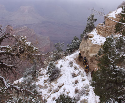
Then we looked back across the river and noticed the mule train following the River Trail which is carved out of a cliff. It's just as well Mom didn't come with us, as she wouldn't have enjoyed watching Dad up there!

We waited for them to cross the bridge, then headed to Phantom Ranch together.

Phantom Ranch is located in a rare oasis of trees and running water - an area that humans have used for centuries. We did some exploring but didn't venture too far away from the cold beer, hot steak, soft beds and interesting ranger stories.

When we headed to the mule corral this morning, we couldn't help noticing a slight change in the weather!
After a detailed pre-mule briefing from the wrangler, Dad and the other riders headed down Bright Angel Trail.
'Bent and I took the shuttle bus to the South Kaibab trailhead. It's 400' higher (7200' instead of 6800') and there was a good ol' snowstorm blowing by the time we were dropped off. (Sniff - I miss snow.) I'm used to the weather getting colder as I hike (usually uphill), but the hike into the Canyon is the other way around, getting milder as you go lower. It felt weird starting down the trail with a pack that seemed too light for the weather conditions.
We used trekking poles to save our knees during the 4,900' vertical descent - and to prevent us from slipping off a cliff. We thought about Urthbuoy portaging his kayak down this trail!
As we got lower, the snow turned into cold rain, and we got below the main clouds into better visibility. The South Kaibab is very exposed, which makes for spectacular scenery.
I got at least a dozen rainbow pics when the sun started to emerge - wide angle lens, telephoto, polarizer, no polarizer, yada yada.
The reason I had so much time for photography was that 'Bent dropped his sunglasses somewhere on the trail and disappeared uphill for a 15-minute exploratory tour. Sadly, he was unsuccessful - and I got chilled.
The weather kept improving and so did the views.
This photo shows the Colorado River with the treed valley of Bright Angel Creek heading north. That's where Phantom Ranch and Bright Angel Campground are located. I'm now reading a book that talks about accidents in the Grand Canyon, and one of the common mishaps is for people to stand too close to the edge of a cliff (like I did) to take a photo (like I did) but the edge of the cliff crumbles away while they stand there. So I'm glad I got this pic because I probably shouldn't have been there, so I won't be doing it again!
We crossed the Kaibab Bridge just before Phantom Ranch.
Then we looked back across the river and noticed the mule train following the River Trail which is carved out of a cliff. It's just as well Mom didn't come with us, as she wouldn't have enjoyed watching Dad up there!
We waited for them to cross the bridge, then headed to Phantom Ranch together.
Phantom Ranch is located in a rare oasis of trees and running water - an area that humans have used for centuries. We did some exploring but didn't venture too far away from the cold beer, hot steak, soft beds and interesting ranger stories.
Saturday Nov 28, 2009 #
Trekking (time discounted) 45:00 [1]
shoes: Salomon XA Pros - Tomato
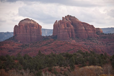
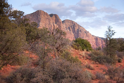
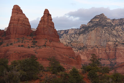
Morning hike around Red Rock State Park in Sedona. There is soooo much good hiking, trail running and mountain biking in this area - 'Bent and I should spend a week here some time. (Although I wonder if I could ever stop thinking about mountain lions...)

Dad and 'Bent sat on the Wildlife Watching Bench. It didn't actually work.

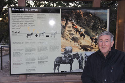
Late afternoon walk along the Grand Canyon Rim Trail. Dad had the orientation for his mule ride, including a mandatory gear review and weigh-in.

Happy Birthday, 'Bent! :-)
Dad and 'Bent sat on the Wildlife Watching Bench. It didn't actually work.
Late afternoon walk along the Grand Canyon Rim Trail. Dad had the orientation for his mule ride, including a mandatory gear review and weigh-in.
Happy Birthday, 'Bent! :-)
Friday Nov 27, 2009 #
Note
Arrived in Arizona for the first leg of my Dad's long-awaited "bucket list" trip to the bottom of the Grand Canyon. 'Bent, Dad and I flew to Phoenix, drove to Sedona and ate far too much Mexican food.

Thursday Nov 26, 2009 #
Note
The Plan: Get lots of stuff done followed by a relaxing hour of yoga and strength.
The Reality: I'd sent a sensitive e-mail on a local political issue to a few friends, and someone accidentally forwarded it to a group e-mail ID that includes pretty much everyone in town - and out of town - who might be interested in the issue, including folks on the other side who now know exactly what my strategy will be. Sigh. That is one of the risks of using e-mail, of course, but... shite!
The Silver Lining: The conservation authority enforcement truck was spotted in the vicinity of the hunter's house. Too bad he chose this week to move his tree stand back from the trail after leaving it there all year. We'd told the enforcement manager about the deer baiting last weekend, but their initial response was that they couldn't do anything. Maybe they just went for a hike to check things out, or maybe they dropped in to say hello. I'm curious!
Wednesday Nov 25, 2009 #
Note
Lots of great CNYO events coming up in New York state! My 2010 calendar is all marked up now.
1) Ski-O races most weekends leading up to the U.S. Ski-O Champs Feb. 11-16 in Craftsbury, VT. (When we went to VT, everyone told us that Craftsbury was the best place to XC ski.)
2) Snowgaine (a perennial favourite for Canadian adventure racers) - Feb. 27-28
3) 24-hr Rogaine (and shorter versions) - July 31-Aug. 1
Note
I can't remember which of the folks at our place last night were interested in the video made at a Sarah Palin book signing, but here it is, courtesy of Urthbuoy. Be prepared to cringe at her supporters' comments, especially later in the video. I don't know how the interviewer kept a poker face.
http://www.youtube.com/watch?v=mKKKgua7wQk
http://www.youtube.com/watch?v=mKKKgua7wQk
Running (Trail & Off-trail) 30:00 [2] 3.5 km (8:34 / km)
shoes: Salomon XA Pros - light blue
I put on blaze orange and went for a run past The Hunter's place. There has been progress over the past week since my letter to the editor was published and another local resident removed his hunting scent pads from conservation land. For the past year, he's had two hunting tree stands right on his property line, pointed outward. Suddenly in the past few days, he's down to just one, and it is 15-20 meters inside his property line. It's still pointed toward the trail on conservation land where his scent pads were hung, but this is progress.
I've also learned from the municipality that his property zoning forbids hunting, but I'm mostly interested in keeping him off conservation land.
I've also learned from the municipality that his property zoning forbids hunting, but I'm mostly interested in keeping him off conservation land.
Tuesday Nov 24, 2009 #
Note
Congratulations to Crash, 'Bent, Gorgeous and Goose for winning last night's Caledon Community Map trivia night at the Toby Jug pub. I was surprised to see it evolve into a seriously competitive event with church ladies pushing town planners aside in their race to be the first to answer a question. The Town Councillor was on the last place team - hmm. If there's another one, we need to get Phatty, Leanimal, Rocky and Slowrunner to team up and challenge the defending champions. (I'm ineligible because I worked on the map.)
Ski Training 47:00
Ski bounding session at our place led by Coach LD. It was a weird, warm night with heavy fog, so our headlamps didn't create much light in the darkness. We saw copious evidence that the local deer population is enjoying the clover we planted over the geothermal loop. This meant we had to choose our locations *very* carefully when Coach LD made us drop down for push-ups, sit-ups and burpees. I'm pretty useless at all this stuff, so this was good for me! Goose, Coach LD, Phatty, Leanimal, Rocky and Scooby made it look easy.
We followed this up with an early birthday bash for 'Bent. Thanks to everyone for arranging a terrific celebration including crab legs, homemade cookies and an excellent surprise gift.
We followed this up with an early birthday bash for 'Bent. Thanks to everyone for arranging a terrific celebration including crab legs, homemade cookies and an excellent surprise gift.
Monday Nov 23, 2009 #
Note
The plot thickens... The nearby hunter who put up a camouflaged tree stand on his property boundary pointing at a trail on conservation land has gone a step further. Now he has hung scent pads (normally doe urine) across the trail to attract bucks to his tree stand. After a series of phone calls around Ontario, I've confirmed that this is legal. All he has to say is that he enjoys looking at deer from his back yard. It's no different from putting out a salt lick or apples, and apparently he's allowed to do that even though it's not his land. Until he shoots a trail runner wearing a white hat or a child who is bushwhacking with an orienteering map, the authorities can do nothing.
The Ontario Federation of Anglers and Hunters agrees that it's unethical and reflects poorly on good hunters, but a guy pretty much has to shoot someone to get his OFAH membership removed - and maybe not then. I asked them if they have a higher standard for their hunters, given that Simcoe County Forest now permits hunting only for OFAH members in the forest where the local woman was killed on the hiking trail. It turns out the real answer is a practical one, not a matter of higher qualifications, as the news stories suggested. OFAH members carry $3M of liability insurance, so if they shoot someone, there is coverage.
The Ontario Federation of Anglers and Hunters agrees that it's unethical and reflects poorly on good hunters, but a guy pretty much has to shoot someone to get his OFAH membership removed - and maybe not then. I asked them if they have a higher standard for their hunters, given that Simcoe County Forest now permits hunting only for OFAH members in the forest where the local woman was killed on the hiking trail. It turns out the real answer is a practical one, not a matter of higher qualifications, as the news stories suggested. OFAH members carry $3M of liability insurance, so if they shoot someone, there is coverage.