Training Log Archive: BashIn the 7 days ending Mar 15, 2009:
| |||||||||||||||||||||||||||||||||||||||||||||||||||||||||||||||||||||||||||||||
| « | » |
| » now | ||||||||||
| Mo | Tu | We | Th | Fr | Sa | Su | |||||||
Sunday Mar 15, 2009 #
Note
(rest day)
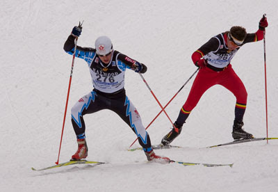
Bluebird day to watch the long race on the final day of the Canadian XC Ski Championships. It eventually got so warm that some skiers wore nothing but their race bib on top. Not the best day for ski racing, but a great day to be a spectator.
Don't know how VO2Max was able to wear a toque out there for more than 2 hrs, skiing 50 km!

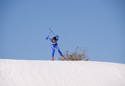
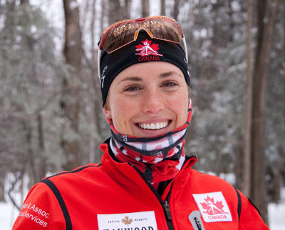
Brittany's skis were slow today, but in spite of the extra poling, she finished in the Canadian Champs bronze medal position.
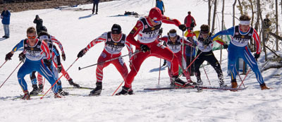
The lead men stayed together throughout, and it was exciting to see them go by on each lap. VO2Max's friend Chris Butler (far right) took the bronze in the Canadian Champs.
Don't know how VO2Max was able to wear a toque out there for more than 2 hrs, skiing 50 km!
Brittany's skis were slow today, but in spite of the extra poling, she finished in the Canadian Champs bronze medal position.
The lead men stayed together throughout, and it was exciting to see them go by on each lap. VO2Max's friend Chris Butler (far right) took the bronze in the Canadian Champs.
Saturday Mar 14, 2009 #
Orienteering (geocaching) 2:50:00
(Time discounted an hour for standing around. Not sure if I should call it orienteering, but it was more like that than anything else!)
For the Rock & Ice Ultra, we need to know how to use the GPS we are required to carry. I'm confident with map & compass (which I will also have), but I had no clue how to use Goose's GPS.
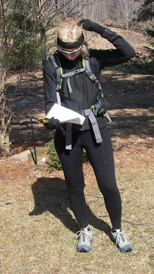
'Bent, BulletDog and I headed out on a mission to find 4 geocaches in Palgrave East. Since my camera is still lying somewhere along last week's Snowgaine course, 'Bent was the photographer today.

We searched high and low (literally) for the first one with no luck. I'd been thinking that geocaching and orienteering had some similarities and might appeal to similar people, but I hadn't anticipated the "hide and seek" nature of finding the caches, given the large range of error of a GPS and the lack of information on the type of feature that might conceal the cache. I didn't find that part particularly exciting, probably because I'm used to just finding a control, then moving on without much drop in heart rate. If a family was just out for a hike though, I can see how that part would be fun.
'Bent discovered the next two geocaches, and we proudly signed the log books. Upon leaving the one called Palgrave Red, which is concealed in thick bush, I noticed that my SPOT satellite messenger device had been torn off my pack. No idea when it had happened, but I felt stupid (a) because I'd commented on the poor design of the clip at the start of our outing, and (b) because it's only 6 days since I lost my camera while bushwhacking, so you'd think I'd be smarter by now.
I've been testing the SPOT - which I won in a Get Out There Magazine contest - in hopes of letting people track me during the Rock & Ice Ultra. However, so far SPOT hadn't spoken to me. I'd carried it around for the entire Snowgaine, and it hadn't sent a single tracking message to a satellite. SPOT isn't exactly lightweight, so if it didn't start sending signals this weekend, it was going to stay home.
'Bent and I went back into the thick forest and spread out, looking for SPOT's bright orange face. We got back to the geocache and meandered around the area like I had done before. No luck. So we retraced our steps through Palgrave, visiting the other two geocache sites, then following our route back home. Because SPOT has a 911 feature, it's a bit like losing a credit card. You either want to find it or cancel it pretty quickly. I didn't want someone finding SPOT, hitting the 911 button and initiating a rescue that I would definitely feel guilty about - and might even be financially responsible for. I'm not sure how that works.
I raced inside and turned on my PC. Yahoo!!!!! SPOTTY had wisely chosen today to start beaming up! The poor thing was bravely broadcasting its location just 15 m from the Palgrave Red geocache. So... back to Palgrave with SPOT's coordinates entered into our GPS. Based on our past experience, we'd need to scour a thickly forested area at least 15-20 meters in diameter, and it was getting late in the day. Just as we entered the edge of the target zone, 'Bent spotted it - yay!!!

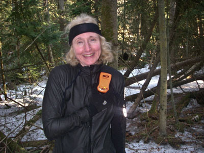
That was even better than geocaching.
For the Rock & Ice Ultra, we need to know how to use the GPS we are required to carry. I'm confident with map & compass (which I will also have), but I had no clue how to use Goose's GPS.
'Bent, BulletDog and I headed out on a mission to find 4 geocaches in Palgrave East. Since my camera is still lying somewhere along last week's Snowgaine course, 'Bent was the photographer today.
We searched high and low (literally) for the first one with no luck. I'd been thinking that geocaching and orienteering had some similarities and might appeal to similar people, but I hadn't anticipated the "hide and seek" nature of finding the caches, given the large range of error of a GPS and the lack of information on the type of feature that might conceal the cache. I didn't find that part particularly exciting, probably because I'm used to just finding a control, then moving on without much drop in heart rate. If a family was just out for a hike though, I can see how that part would be fun.
'Bent discovered the next two geocaches, and we proudly signed the log books. Upon leaving the one called Palgrave Red, which is concealed in thick bush, I noticed that my SPOT satellite messenger device had been torn off my pack. No idea when it had happened, but I felt stupid (a) because I'd commented on the poor design of the clip at the start of our outing, and (b) because it's only 6 days since I lost my camera while bushwhacking, so you'd think I'd be smarter by now.
I've been testing the SPOT - which I won in a Get Out There Magazine contest - in hopes of letting people track me during the Rock & Ice Ultra. However, so far SPOT hadn't spoken to me. I'd carried it around for the entire Snowgaine, and it hadn't sent a single tracking message to a satellite. SPOT isn't exactly lightweight, so if it didn't start sending signals this weekend, it was going to stay home.
'Bent and I went back into the thick forest and spread out, looking for SPOT's bright orange face. We got back to the geocache and meandered around the area like I had done before. No luck. So we retraced our steps through Palgrave, visiting the other two geocache sites, then following our route back home. Because SPOT has a 911 feature, it's a bit like losing a credit card. You either want to find it or cancel it pretty quickly. I didn't want someone finding SPOT, hitting the 911 button and initiating a rescue that I would definitely feel guilty about - and might even be financially responsible for. I'm not sure how that works.
I raced inside and turned on my PC. Yahoo!!!!! SPOTTY had wisely chosen today to start beaming up! The poor thing was bravely broadcasting its location just 15 m from the Palgrave Red geocache. So... back to Palgrave with SPOT's coordinates entered into our GPS. Based on our past experience, we'd need to scour a thickly forested area at least 15-20 meters in diameter, and it was getting late in the day. Just as we entered the edge of the target zone, 'Bent spotted it - yay!!!
That was even better than geocaching.
Friday Mar 13, 2009 #
Note
If you think you've ever had a rough time in the outdoors, read "The Worst Journey in the World" by Apsley Cherry-Garrard, a member of the Scott Expedition in Antarctica. Hoo boy. Even though the action took place a century ago, it doesn't feel "historical". He paints a great picture of men sharing adventures, jokes, challenges and tragedy, and you can easily imagine how it would feel to be there. (But you'll be grateful you're not!)
Thursday Mar 12, 2009 #
Mountain Biking (Trainer) 46:00
Higher pace than usual as 'Bent and I tried to keep up with the breakaways at the end of the 1993 World Road Cycling Champs. After being virtually ignored earlier in the race coverage, a certain Lance Armstrong got into the front group, and Phil Liggett talked about this surprising development. Liggett kept reminding the viewers who this relatively unknown rider was - a "rookie American", a "former triathlete" and a "21-year-old from Texas in his first year of professional racing". He was a lot beefier than the Lance we know, and - I gotta say - he looked pretty cool racing with a gold earring instead of a little radio.
There were some great lines - with 20/20 hindsight.
"With Greg LeMond planning to retire next year, I wonder if we are looking at the man who could become his replacement in the U.S."
"Miguel Indurain has said he will race for 3 more years. Will he be the first man to win 6 consecutive Tours de France?"
"If Armstrong is going to do well in the long tours, he's going to have to work on his time trialling."
But the best of all was:
"After winning this World Championship and a stage in the Tour de France earlier this year, Armstrong is going to look back at his first year of racing and say... what else is there? I've already done it all!" !!!!
Well worth watching sometime - great trainer material.
Power Yoga 23:00 [1]
Some quality time with Rodney Yee.
Wednesday Mar 11, 2009 #
Mountain Biking (Trainer) 30:00 [3]
While watching The Daily Show.
Strength & Mobility (Legs) 23:00 [2]
Strength & Mobility (Upper body) 15:00 [2]
While watching the Colbert Report.
Monday Mar 9, 2009 #
Note
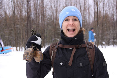
Crash and I went to Highlands Nordic to watch some of the Canadian XC Ski Championships. Crash has known VO2Max his whole life, and this was the first time she'd seen him XC ski racing. She was an absolute pro with the cow bells!
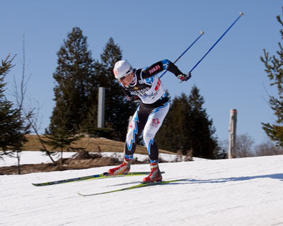
VO2Max looked great. A good performance in the Canadian Champs can be worth a lot of money to an amateur athlete, so this is a big week.
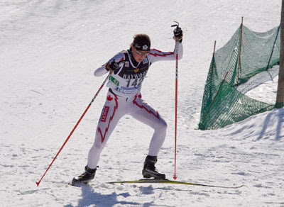
Brittany was fighting a cold, but was in good humour anyway.
VO2Max looked great. A good performance in the Canadian Champs can be worth a lot of money to an amateur athlete, so this is a big week.
Brittany was fighting a cold, but was in good humour anyway.