Training Log Archive: BashIn the 7 days ending May 4, 2008:
| |||||||||||||||||||||||||||||||||||||||||||||||||||||||||||||||||||||||||||||||
| « | » |
| » now | ||||||||||
| Mo | Tu | We | Th | Fr | Sa | Su | |||||||
Saturday May 3, 2008 #
Note
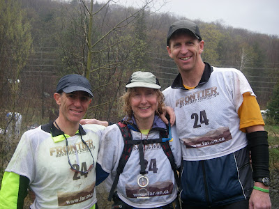
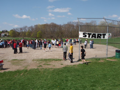
FAR Deerhust Adventure Challenge with 'Bent and Goose
Adventure Racing race 6:16:00 [3] **
Frontier Adventure Challenge Deerhurst - This was a very different concept for Frontier, whose philosophy has always been that adventure races should feel like point-to-point wilderness journeys. Today's race was a series of loops, like a triathlon. We had only one transition area, and it was at the start/finish line at Deerhurst.
First there was a bike navigation leg, then paddling, then a trek. It wasn't a race format that everyone would like, and I wouldn't want it to become the norm for all FAR races, but I enjoyed doing it once, and it was a good use of Deerhurst and its surrounding terrain. Both the trek and the biking were interesting and challenging. The paddle was challenging due to the cold, rainy weather conditions, but not particularly interesting.
'Bent, Goose and I got off to a great start in the MTB section, which began with a few km of paved road before turning off onto a snowmobile trail. Goose towed me up the hills, and we flew past some teams who had started too quickly.
Then we got into the section labelled "Mountain Bike Orienteering". It's great when adventure race organizers try to incorporate orienteering into their events. Unfortunately, because some of them have little experience orienteering, they may not know the basic principles of setting a course, and this section was a perfect example.
1) Orienteering controls are placed on features visible on the map, and you should be able to navigate to them using other features on the map.
2) This is admittedly very difficult to do on a 1:50,000 topo map, so where the feature isn't a point or isn't visible on the map, it's acceptable in an adventure race to provide extra written instructions, e.g. "at start of a gated trail running generally south of the main trail". (As long as the UTM provided is accurate, and there are features that enable racers to navigate to a nearby attackpoint.)
3) When the locations of CPs have only been verified by GPS (as in this case), it's not orienteering. If the race director is unable to verify the location of CPs using map and compass - the tools that the racers are using - then the CPs have not been verified. It's OK to use GPS as a supplementary tool for back-up, but the organizers have to look at the map too, and they should go through the exercise of drawing UTMs on the map themselves so that they can see what the racers will see and work with.
4) If the map doesn't support your chosen CP location for whatever reason, move your CP to a place that *does* support it. When I set orienteering courses, I probably move 25% of the controls that I've selected in advance in order to be fair to competitors.
Having said all that, I enjoyed most of this section a lot. Even though we were close to Deerhurst, we were riding on fun, mucky snowmobile trails similar to what we would have found a lot farther from town.
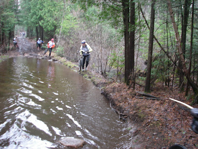
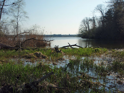
Our team was riding well, and we were seeing the leaders a lot for much of this section. Between map and instructions, reasonable information was provided to find CPs 1-4. We did CP5 and CP7 next (you could go in any sequence), and I'd say that finding them relied too heavily on luck - but we were lucky there. We were feeling pretty good with just 2K of snowmobile trail left to go and two CPs to find. The first one was CP6. Teams mark their own CPs on the map using UTM coordinates provided, and here is the location we were given for CP6.
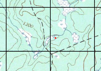
Technically, a UTM coordinate can represent any point 50m in any direction from the red point, so we always assume some imprecision. In this case, I'm told that the CP was placed north of the marsh - at least 100 m from the UTM coordinate. I've had a fair bit of course setting experience, and that actually hurt me here. I could imagine a course setter putting the flag in the wrong place on the south side of the marsh, but surely any course setter would recognize the marsh and the marked trails as being the primary features to guide racers to the control, so if they were going to put their CP in the wrong place, they would be wrong in this general area. The CP description was "intersection of two ATV trails", and we knew that the trails weren't on the map. We found and followed lots of trails - spent more than an hour looking for it with no success.
Most of the teams found this control, so there is clearly a lesson to take away. (In spite of our frustration about CP6, one of the things I love about adventure racing is that there is always something new to learn - even after dozens and dozens of races.) The Lesson: When it becomes clear that a GPS error has been made in setting an adventure race course, we should extend our search in all directions, ignoring the map entirely and imagining ourselves as someone navigating with nothing but a GPS in our hands. In this case, we searched extensively east, west and south of the correct UTM coordinate area, but did not try going north of it.
We finally abandoned the search and picked up CP8 on our way back to Deerhurst. We switched to our paddling gear just as the rain started to get more intense. We headed out onto Peninsula Lake for a 12K paddle to visit two CPs on the north and south shores on the east side of the lake. We were fortunate to get a good canoe, since I heard that most teams had whitewater canoes that didn't track well. We passed a couple of teams and sang a bunch of songs. The major discovery of the weekend was that Angus has a phenomenal Elvis voice, which he attributed to his cold, but I think he was being far too modest.
Then we moved onto the final trek, which appeared deceptively easy, given that controls were placed on and near the trail network that Deerhurst has set up for their guests. Several experienced navigators hated this map, which was a cartoon.
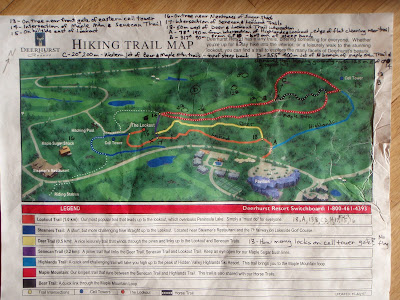
I'm one of the few orienteers who liked this section. For me, it was because - unlike the mountain bike orienteering section, where we were given a topo map and should have been able to expect accuracy - it was clear that this map made no such promises, so we had to be creative in which pieces of information we could rely on at different times. The trail descriptions included some distances, but because the map had a 3D component, you couldn't use relative trail lengths on the map. North moved around as you moved around the map, so it provided some information, but not much. Most trails weren't marked (surprisingly), and there were unmarked trails on the map too, so there were only a few things we could depend on firmly, like two cell phone towers, a lookout tower, the hill and the surrounding golf course. No question, if you got lost somewhere in the heart of this map, it would be a pain to relocate!
This section went really well for us, with a bobble at the end where we descended to the wrong road enroute to the Sugar Shack and had to climb partway up the hill again. Goose had cleverly drawn in some tees and greens using the golf course map, and that helped with our attackpoint for control D. Results aren't posted yet, but we made up lot of time through this section and the paddling section, so in spite of our blow-out in the MTB section, I feel good about our teamwork and the way we raced throughout the day.
When we reached the finish line, amazingly, we were in 4th place behind FB's team, Salomon-Suunto and the Salomon Bobkittens. I was prepared to protest the misplacement of CP6, since that would have got us 1st Coed - except for one minor detail. A piece of our sodden passport did not reach the finish line.
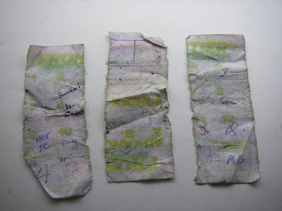
No excuses there. The Bobkittens mentioned that they had Mac-tacked their passport. To be honest, we should have known about this - and we had lots of Mactac with us But we've never had an issue with our passports in all the races we've done, and it's just one of those adventure racing details that has never come up. So we were a DNF with no argument (although I'd be happy to teach FAR about the waterproof paper that orienteers use for control cards - a much better system!)
Regardless, it was a fun day of racing with a couple of excellent teammates. I'm disappointed about our result, but I don't feel overly negative about the event, and I feel really good about how we moved through the course - with the exception of CP6. It was great to have the chance to hang out with our AR friends for the rest of the weekend at Deerhurst, since many of us were volunteering for the high school race on Sunday.
First there was a bike navigation leg, then paddling, then a trek. It wasn't a race format that everyone would like, and I wouldn't want it to become the norm for all FAR races, but I enjoyed doing it once, and it was a good use of Deerhurst and its surrounding terrain. Both the trek and the biking were interesting and challenging. The paddle was challenging due to the cold, rainy weather conditions, but not particularly interesting.
'Bent, Goose and I got off to a great start in the MTB section, which began with a few km of paved road before turning off onto a snowmobile trail. Goose towed me up the hills, and we flew past some teams who had started too quickly.
Then we got into the section labelled "Mountain Bike Orienteering". It's great when adventure race organizers try to incorporate orienteering into their events. Unfortunately, because some of them have little experience orienteering, they may not know the basic principles of setting a course, and this section was a perfect example.
1) Orienteering controls are placed on features visible on the map, and you should be able to navigate to them using other features on the map.
2) This is admittedly very difficult to do on a 1:50,000 topo map, so where the feature isn't a point or isn't visible on the map, it's acceptable in an adventure race to provide extra written instructions, e.g. "at start of a gated trail running generally south of the main trail". (As long as the UTM provided is accurate, and there are features that enable racers to navigate to a nearby attackpoint.)
3) When the locations of CPs have only been verified by GPS (as in this case), it's not orienteering. If the race director is unable to verify the location of CPs using map and compass - the tools that the racers are using - then the CPs have not been verified. It's OK to use GPS as a supplementary tool for back-up, but the organizers have to look at the map too, and they should go through the exercise of drawing UTMs on the map themselves so that they can see what the racers will see and work with.
4) If the map doesn't support your chosen CP location for whatever reason, move your CP to a place that *does* support it. When I set orienteering courses, I probably move 25% of the controls that I've selected in advance in order to be fair to competitors.
Having said all that, I enjoyed most of this section a lot. Even though we were close to Deerhurst, we were riding on fun, mucky snowmobile trails similar to what we would have found a lot farther from town.
Our team was riding well, and we were seeing the leaders a lot for much of this section. Between map and instructions, reasonable information was provided to find CPs 1-4. We did CP5 and CP7 next (you could go in any sequence), and I'd say that finding them relied too heavily on luck - but we were lucky there. We were feeling pretty good with just 2K of snowmobile trail left to go and two CPs to find. The first one was CP6. Teams mark their own CPs on the map using UTM coordinates provided, and here is the location we were given for CP6.
Technically, a UTM coordinate can represent any point 50m in any direction from the red point, so we always assume some imprecision. In this case, I'm told that the CP was placed north of the marsh - at least 100 m from the UTM coordinate. I've had a fair bit of course setting experience, and that actually hurt me here. I could imagine a course setter putting the flag in the wrong place on the south side of the marsh, but surely any course setter would recognize the marsh and the marked trails as being the primary features to guide racers to the control, so if they were going to put their CP in the wrong place, they would be wrong in this general area. The CP description was "intersection of two ATV trails", and we knew that the trails weren't on the map. We found and followed lots of trails - spent more than an hour looking for it with no success.
Most of the teams found this control, so there is clearly a lesson to take away. (In spite of our frustration about CP6, one of the things I love about adventure racing is that there is always something new to learn - even after dozens and dozens of races.) The Lesson: When it becomes clear that a GPS error has been made in setting an adventure race course, we should extend our search in all directions, ignoring the map entirely and imagining ourselves as someone navigating with nothing but a GPS in our hands. In this case, we searched extensively east, west and south of the correct UTM coordinate area, but did not try going north of it.
We finally abandoned the search and picked up CP8 on our way back to Deerhurst. We switched to our paddling gear just as the rain started to get more intense. We headed out onto Peninsula Lake for a 12K paddle to visit two CPs on the north and south shores on the east side of the lake. We were fortunate to get a good canoe, since I heard that most teams had whitewater canoes that didn't track well. We passed a couple of teams and sang a bunch of songs. The major discovery of the weekend was that Angus has a phenomenal Elvis voice, which he attributed to his cold, but I think he was being far too modest.
Then we moved onto the final trek, which appeared deceptively easy, given that controls were placed on and near the trail network that Deerhurst has set up for their guests. Several experienced navigators hated this map, which was a cartoon.
I'm one of the few orienteers who liked this section. For me, it was because - unlike the mountain bike orienteering section, where we were given a topo map and should have been able to expect accuracy - it was clear that this map made no such promises, so we had to be creative in which pieces of information we could rely on at different times. The trail descriptions included some distances, but because the map had a 3D component, you couldn't use relative trail lengths on the map. North moved around as you moved around the map, so it provided some information, but not much. Most trails weren't marked (surprisingly), and there were unmarked trails on the map too, so there were only a few things we could depend on firmly, like two cell phone towers, a lookout tower, the hill and the surrounding golf course. No question, if you got lost somewhere in the heart of this map, it would be a pain to relocate!
This section went really well for us, with a bobble at the end where we descended to the wrong road enroute to the Sugar Shack and had to climb partway up the hill again. Goose had cleverly drawn in some tees and greens using the golf course map, and that helped with our attackpoint for control D. Results aren't posted yet, but we made up lot of time through this section and the paddling section, so in spite of our blow-out in the MTB section, I feel good about our teamwork and the way we raced throughout the day.
When we reached the finish line, amazingly, we were in 4th place behind FB's team, Salomon-Suunto and the Salomon Bobkittens. I was prepared to protest the misplacement of CP6, since that would have got us 1st Coed - except for one minor detail. A piece of our sodden passport did not reach the finish line.
No excuses there. The Bobkittens mentioned that they had Mac-tacked their passport. To be honest, we should have known about this - and we had lots of Mactac with us But we've never had an issue with our passports in all the races we've done, and it's just one of those adventure racing details that has never come up. So we were a DNF with no argument (although I'd be happy to teach FAR about the waterproof paper that orienteers use for control cards - a much better system!)
Regardless, it was a fun day of racing with a couple of excellent teammates. I'm disappointed about our result, but I don't feel overly negative about the event, and I feel really good about how we moved through the course - with the exception of CP6. It was great to have the chance to hang out with our AR friends for the rest of the weekend at Deerhurst, since many of us were volunteering for the high school race on Sunday.
Running warm up/down 13:00 [1]
Wednesday Apr 30, 2008 #
Running (Trail) 42:00 [3]
Early morning run in the Cootes Paradise area, just before the excitement began for the GHO School Adventure Challenge. Absolutely beautiful day!
My running companion was Slice - the current leader in the 5 Peaks Trail Running Series. Fortunately, she went slowly so that I could keep up. Great chance to chat and catch up.
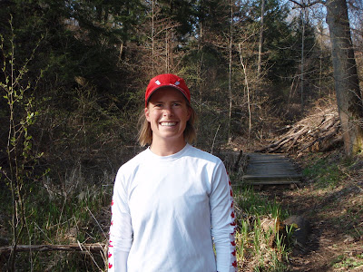
My running companion was Slice - the current leader in the 5 Peaks Trail Running Series. Fortunately, she went slowly so that I could keep up. Great chance to chat and catch up.
Running (Trail) 12:00 [1] **
I hung most of my assigned controls while sipping on a wonderful coffee that Slice had picked up on a Second Cup run. Toward the end, I did a bit of running.
It was exciting to be involved in what we believe was the largest-ever orienteering event in Ontario history! Close to 900 students from grades 6-12 came out for the Hamilton School Adventure Challenge. Honestly, the papparazzi were driving us nuts after awhile!
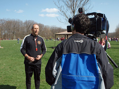
With the media out in force, it's a good thing we were all properly attired!

Ray Kitowski deserves to take a huge bow for another successful school meet. He is impeccably organized, and it is surprisingly relaxing and pleasurable to volunteer for this huge event.
It was exciting to be involved in what we believe was the largest-ever orienteering event in Ontario history! Close to 900 students from grades 6-12 came out for the Hamilton School Adventure Challenge. Honestly, the papparazzi were driving us nuts after awhile!
With the media out in force, it's a good thing we were all properly attired!
Ray Kitowski deserves to take a huge bow for another successful school meet. He is impeccably organized, and it is surprisingly relaxing and pleasurable to volunteer for this huge event.
Tuesday Apr 29, 2008 #
Mountain Biking (Trail & Road) 1:20:00
Visited some, um, places near Barrie while course setting for the Salomon Navstock Raid. It's going to be hilly. There are still big piles of snow wherever it's a bit shady. Can't say much more than that...
Monday Apr 28, 2008 #
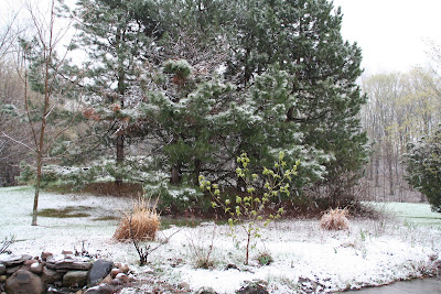
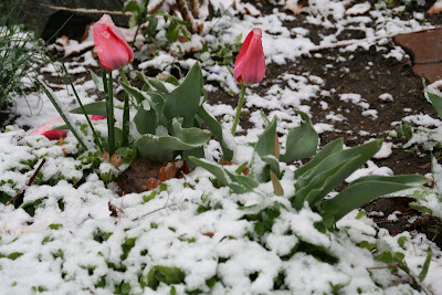
Note
April will be over in a few days, but today we awoke to wet snow falling rather heavily. Not sure when it started, but it lasted for several hours, sticking to the ground and trees. It melted in the afternoon. Now I'm sorry that I took the duvet off the bed recently, but at least we've got a big fire going tonight!
Running (Trail) 29:13 [4] 5.0 km (5:51 / km)
I was sooooo unmotivated today, which is a little unusual. I managed to convince myself to get dressed to go for a 30-minute run, and then I remembered... hey, I'm an engineer! If we make this experience geekier, I'll have more fun! So I grabbed my Forerunner and decided to measure a time trial loop on trails behind our place. This of course gave me the nerdy thrill of checking my instantaneous pace, etc. It turns out that one of my regular hilly trail loops is exactly 5K long, which was a good discovery. It went faster than my recent 5K on our dirt road, which makes me think that the road run (measured with my car) must really be a bit longer.
Route - Front door, long way through F&M's property, Poison Ivy Trail to Bruce Junction, into Koturbash and clockwise around Charlevoix, cross-country trail to meet the Bruce, then Swamp Trail, Hawk Hill, Thinker's Hill (to the bench), then home via the short route through F&M's, past the front and down the driveway to the "Beware of Dog" sign.
Route - Front door, long way through F&M's property, Poison Ivy Trail to Bruce Junction, into Koturbash and clockwise around Charlevoix, cross-country trail to meet the Bruce, then Swamp Trail, Hawk Hill, Thinker's Hill (to the bench), then home via the short route through F&M's, past the front and down the driveway to the "Beware of Dog" sign.
Strength & Mobility (Core) 40:00 [2]
Hard Core Monday. Phatty and Leanimal have been doing a lot of trash talking before this weekend's adventure race, but I think they've only made it all the way through this DVD once or twice. Sure, you guys will beat us on the running and biking, but If one of the disciplines happens to be sit-ups, you guys are soooo going DOWN. (Um, and up, then down, then up, then down...)