Training Log Archive: BashIn the 1 days ending Aug 13, 2010:
| ||||||||||||||||||||||||||||||||||||||||
| « | » |
| » now | ||||
| Fr |
Friday Aug 13, 2010 #
Adventure Racing 24:00:00 [3]
shoes: Salomon XA Pro Ult - 2 Tomato
Untamed New England Day 2
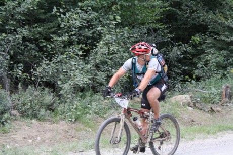
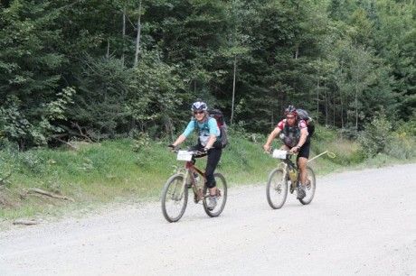
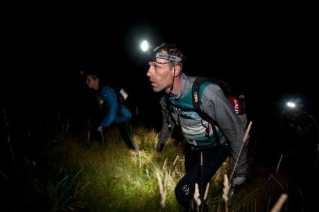
We headed out from the fire hall on our bikes around 1 a.m. - such a relief to be using different muscles! We'd been a bit chilled in wet clothes from our paddle but it didn't take long till we were removing layers and drying out. The ride started on rolling gravel roads and arrived at a track that ran along the Canada-U.S. border. Apparently, the team from Ecuador crossed the border here accidentally without the mandatory copy of their passport that racers were required to carry - oops! We turned onto an ATV trail that started out rideable with a steep uphill climb then deteriorated into mush at the high point. This was a common theme throughout these mountains - swampy ground as we got higher. The descent was a hike-a-bike slog down a mere hint of a trail. We constantly had to heave our bikes over fallen trees and through brush. We were with EMS and Granite so we assumed this was just the way it was for everybody, but after we finally merged with a nice gravel road, we met up with our friends, the Milton Basement Racers, who said they'd ridden beautiful smooth roads the whole way while eating caviar and drinking champagne. (OK, I made some of that up.) Needless to say, we were very happy for them. ;-)
After the next CP, we headed onto some snowmobile trails hoping to find a bridge across the river separating us from the trail system we wanted to be on. We were with Granite at this point and their navigator did a quick dash into the bush and returned to announce that we were close to the river. This was good enough for all of us, as we could bikewhack across the river and get to the road on the other side - a couple hundred meters at most. Wrong! What had appeared to be the river was only a creek, and there was swampy ground and thick vegetation all around it. We continued on our bearing heading east. This was one of the nastiest sections I've ever struggled through in an adventure race and certainly got my heart rate higher than anything else in this event. It's hard enough to get your own body through dense, tangled swamp vegetation. Now add a full suspension bike to the mix, with all kinds of parts to catch on branches at the same time as you're plunging unexpectedly into deep muck. We found the real river and crossed it, getting wet thigh-deep. Then the bikewhacking began again in earnest and eventually (oh, thank God) began to head uphill. Just as it seemed it would never end, we were spit out onto a gravel road.
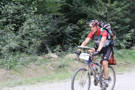
We had a couple of CPs to find in that trail system before heading for the bike drop at a nearby lodge. There were some loose, rocky climbs but at least the sun was starting to rise, which gave us energy again. We figured that we'd probably lost 5 or 6 places as a result of our weird bike route but we remained calm because it was a long race and we had plenty of time to make it up. Harps was navigating perfectly and we knew the previous section would be tough for everyone. The only other team we saw after the bikewhack was Granite, but that didn't cheer us up because we knew they'd been through the same nasty experience as us. When we pulled up at the bike drop at the lodge, there was a strange sight... an empty parking lot with no bicycles in it. "Congratulations, you're the first team to arrive!", the volunteer exclaimed. Rather than the joy he probably expected, we burst into hysterical laughter tinged with shock. Granite arrived a few minutes later and we rushed through our TA to ensure that we could start the trek in first place on the leaderboard. (As it turned out, Granite had a small time credit, so we were actually in 2nd place. I'll take it.)
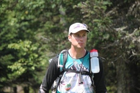
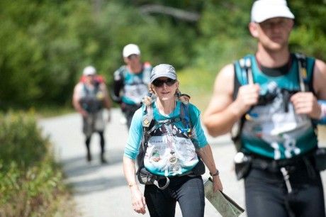
The first part of the trek was on roads that got progressively smaller. We ran the flats and downhills and speed-hiked the uphills. Even at 9 a.m., the morning sun was hot and we knew we'd have to be careful about fluids and electrolytes today.

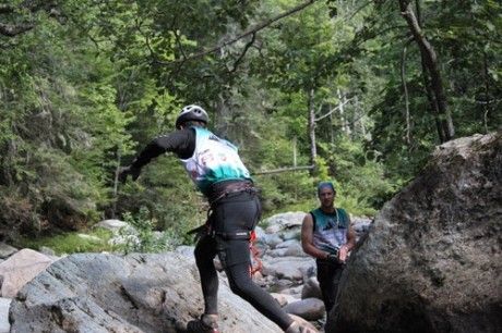
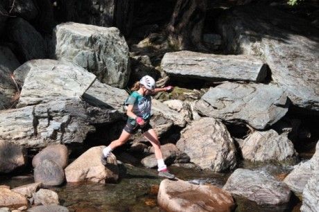
Our route started to head cross-country and our navigation went well but we kept hitting nasty stretches of bushwhacking - open fields of raspberries, logging debris, thick cedars, etc. When we eventually popped out onto the gravel road leading to Magalloway Mountain, we met Luis Moreira who told us that Granite was in 1st place two minutes ahead of us on the road, and Skandia was a few minutes behind us, having gained almost an hour on both Granite and us in this section.
We were short of both water and water purification pills at this point, so our priority was finding a decent-looking stream before we climbed to the summit. We couldn't afford to worry about Skandia passing us, which they did shortly after we stopped at a stream. The climb up Magalloway Mountain was on trail but the taxpayers certainly saved a lot of money by not building switchbacks! Friendly volunteers surrounded us at the top and let us know that some CPs had been removed from the course.

All of us had a few hot spots, so we had previously decided to air our feet out for 10 minutes up here. As it turned out, this gave us a chance to plan our new routes for the revised trek. This photo shows my lovely feet which actually were - and remained - the least damaged of anyone on the team.

There was a mandatory team photo at a scenic overlook. We're in 3rd place in this pic and very happy to be there!
Because of where we needed to go next, the trail down Magalloway Mountain didn't make much sense. However, the mountain was steep on all sides and too cliffy to descend on the east side, where we actually needed to go. We opted to head down the north side and contour around as soon as we got past the cliffs. Although it took us a little out of our way, this was the closest access to the main road we wanted to hit when we reached the bottom.


If we thought the bushwhacking was bad before, it's only because we hadn't been here yet. Holy crap! We were on slopes so steep that we were skidding downhill and grasping at saplings whenever we hit an open chute. However, that wasn't very often. Mostly, we were tearing branches apart and stepping over logs onto lower ground that we couldn't see. It was in this section that I gave Kirikou his new nickname, the Bush Whisperer. He can fly through tough bush and is great at weaving together little sections where the going is easier.
That's why he was in front when we heard a crashing sound. The largest moose any of us had ever seen leapt to his feet, angry to be roused from his afternoon nap. (This photo is not our moose - it's one that the course testers saw.) He was glaring at Kirikou. All of us were eyeing trees and thick bush nearby in case the moose charged, grateful that trampling Kirikou would slow the moose down a little before he reached the rest of us. ;-)

The moose stared at us for what seemed like an eternity then decided we weren't worth the trouble. He trotted off and we all exhaled. After finishing the descent off the mountain through thick bush, we were rewarded by a sloppy slog through marshy land and stream vegetation and thigh-deep dunks in mud before reaching the gravel road. We were doing less running and more speed-hiking at this point since we'd drained some energy reserves in today's tough bushwhacking. We probably weren't drinking as much as we should because we were conserving our water purification pills and weren't keen to drink untreated water. I hooked onto the ever-helpful Relentless' tow line since that kept me alongside the boys without needing to focus too much.
We got to the ropes section at Garfield Falls about 1 km after several of us shared a hallucination of a sign pointing to the falls. (It was just a few tree branches and some leaves but we were convinced!) There was a Tyrolean Traverse, a rappel and a bit of stream walking before we climbed back up to where we'd left our packs.

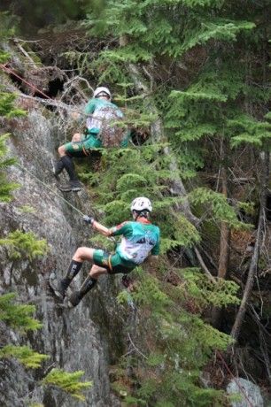
We were the third team to do the ropes, which took about 20-25 minutes. Shortly after our departure, we met a couple of teams coming in, including Team GUATS, who were still doing a fine AR shuffle.
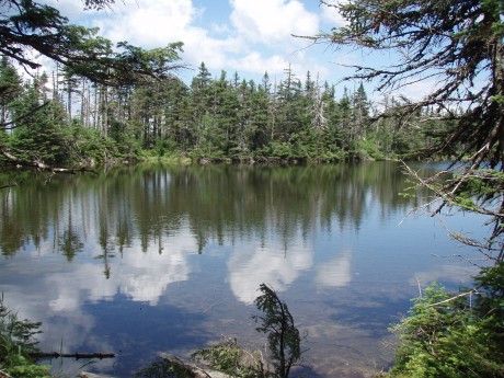
We stopped to purify water where we crossed the river, then headed toward CP22 in late afternoon sunlight. We ran slowly on flats and downhills, knowing that things would slow down soon and we wanted to get most of the trek done before we lost our light. We started in along a trail by a creek. In some places it was OK but it clearly hadn't been travelled in some time. We were heading behind the peak of Stub Mountain and it seemed like we might be too far on the other side of the valley, so we headed over that direction more. According to GUATS, it would have been quicker to stay near the indistinct trail since it got better from time to time. We bushwhacked steadily toward the head of the valley but it was slow going. As we got close to the top near the lake we were heading for, the bushwhacking got exceptionally difficult. There were times we simply couldn't move forward yet we didn't want to get off our bearing too much in case it got dark before we found the little lake behind the peak. We hit a trail shortly before the lake and had an easy walk down to the shore. Kirikou and I generously volunteered to walk along the shallows at the edge of the lake, peering into the forest to look for the flag. (This was hardly necessary but the cold water felt soooo good on our feet.) Relentless and Harps stayed onshore and found the flag.
Looking ahead to CP23, the final summit on the trek, it seemed obvious that we should get there via a ridge walk similar to ones that I've done in many rogaines in the past. It's usually fairly easy to stay close to the high point of a ridge in the dark, particularly if it's narrow and you're careful about pace counting, compass bearing, etc. So our first step was to return to the saddle. It wasn't far but it made all our other bushwhacking today - maybe all the other bushwhacking in our *lives* - look like child's play. It was dark now so we had little peripheral vision. I plunged over a couple of small cliffs and balanced on fallen trees, some of which collapsed and hurtled me into the unknown while others simply scratched me and tore my clothing. It was rare that we could see where we were putting our feet, so we were risking injury with every step. When the altimeter told us that we'd reached the saddle, I called a halt so we could re-evaluate our strategy. The ridge walk simply wasn't going to work. There had to be another way.
I've rarely used an altimeter in AR but it saved our butt this time and I will need to start using one. Using an idea from our ever-creative navigator Harps, we decided to descend about 600' to the 2600' contour, then follow it east until the ground rose to the ridge that we wanted. We could only hope that the terrain down there was faster going than the ridge, since we were adding significant descent and climb to our route. Luckily, it worked out that way.
This section was a full team effort. Relentless kept track of timing. Harps watched the altimeter like a hawk. Kirikou found ways through the bush on an accurate bearing. I watched the map and the bearing and confirmed that all the readings together were making sense and that the terrain was doing what we expected it to do at the time we were expecting it to happen. Coming from an outside team, I was impressed at how smoothly we worked together here and throughout the race without spending a bunch of time debating how to do it. I think this is why we did better at Untamed than most people, including us, expected.
Kirikou led us along a new bearing at the top of the ridge while Harps took altimeter readings. Unfortunately, we stopped short at a false summit near our CP, which meant we did some scrambling around to search for the highest point. It was here that the skin slid off the bottom of Relentless' toe so we had an emergency first aid break. Relentless is a strong workhorse and never complains but the pain must have been excruciating, especially in that bush. The rest of us didn't realize it yet but Harps' feet were turning raw as well, so both guys were soldiering through serious pain in some of the nastiest bush any of us had ever experienced. After nabbing CP23, we had a steep 2 km descent to reach a road. Kirikou led the way and there were some steep sections once again. I had a couple of impressive falls, managing to smash my hip and twist my ankle. I didn't want to complain though because at least my feet still had skin on them!
At last we hit the road near Bosebuck Camp (TA3/TA4/TA5) and did a steady uphill climb for a couple of kms. The next legs were loops from this camp so we knew we'd be seeing this hill again. We arrived at 2:44 a.m. in 4th place behind GUATS (who had an amazing trek), Skandia and Granite. We had planned to prepare for the next leg before taking a 2-hour nap but we were just too fried. We got the UTMs for the bike section, had some food, set up our sleeping bags and did some foot care. I wasn't tremendously effective here. I was in a fatigued state where I became paralyzed by indecision. Will we sleep well in the communal tent or should we sleep on our tarp? Should I use the Primus stoves to make some hot food or just gobble down a cold can of Beefaroni? Is it most important to take off my shoes right now and air my feet? If I take off my shoes, will I be able to get over to that tent where we're going to sleep? If I want dry socks for the next leg, do I need to leave my wet socks on in case I need to put my shoes on? Should I look for my bike and make sure it's OK? How much stuff should I get ready for the next leg so I don't hold the team up after our nap? It all seems silly and obvious now, and it's not as bad as it sounds because I was the second to get to bed. However, I didn't get any hot food, which would have been nice before a chilly 2-hour nap. I need to figure out how to get better at handling TAs when I'm super-tired.
Mmm, gotta say that nap from 3:15-5:15 a.m. was amazing!!
We headed out from the fire hall on our bikes around 1 a.m. - such a relief to be using different muscles! We'd been a bit chilled in wet clothes from our paddle but it didn't take long till we were removing layers and drying out. The ride started on rolling gravel roads and arrived at a track that ran along the Canada-U.S. border. Apparently, the team from Ecuador crossed the border here accidentally without the mandatory copy of their passport that racers were required to carry - oops! We turned onto an ATV trail that started out rideable with a steep uphill climb then deteriorated into mush at the high point. This was a common theme throughout these mountains - swampy ground as we got higher. The descent was a hike-a-bike slog down a mere hint of a trail. We constantly had to heave our bikes over fallen trees and through brush. We were with EMS and Granite so we assumed this was just the way it was for everybody, but after we finally merged with a nice gravel road, we met up with our friends, the Milton Basement Racers, who said they'd ridden beautiful smooth roads the whole way while eating caviar and drinking champagne. (OK, I made some of that up.) Needless to say, we were very happy for them. ;-)
After the next CP, we headed onto some snowmobile trails hoping to find a bridge across the river separating us from the trail system we wanted to be on. We were with Granite at this point and their navigator did a quick dash into the bush and returned to announce that we were close to the river. This was good enough for all of us, as we could bikewhack across the river and get to the road on the other side - a couple hundred meters at most. Wrong! What had appeared to be the river was only a creek, and there was swampy ground and thick vegetation all around it. We continued on our bearing heading east. This was one of the nastiest sections I've ever struggled through in an adventure race and certainly got my heart rate higher than anything else in this event. It's hard enough to get your own body through dense, tangled swamp vegetation. Now add a full suspension bike to the mix, with all kinds of parts to catch on branches at the same time as you're plunging unexpectedly into deep muck. We found the real river and crossed it, getting wet thigh-deep. Then the bikewhacking began again in earnest and eventually (oh, thank God) began to head uphill. Just as it seemed it would never end, we were spit out onto a gravel road.
We had a couple of CPs to find in that trail system before heading for the bike drop at a nearby lodge. There were some loose, rocky climbs but at least the sun was starting to rise, which gave us energy again. We figured that we'd probably lost 5 or 6 places as a result of our weird bike route but we remained calm because it was a long race and we had plenty of time to make it up. Harps was navigating perfectly and we knew the previous section would be tough for everyone. The only other team we saw after the bikewhack was Granite, but that didn't cheer us up because we knew they'd been through the same nasty experience as us. When we pulled up at the bike drop at the lodge, there was a strange sight... an empty parking lot with no bicycles in it. "Congratulations, you're the first team to arrive!", the volunteer exclaimed. Rather than the joy he probably expected, we burst into hysterical laughter tinged with shock. Granite arrived a few minutes later and we rushed through our TA to ensure that we could start the trek in first place on the leaderboard. (As it turned out, Granite had a small time credit, so we were actually in 2nd place. I'll take it.)
The first part of the trek was on roads that got progressively smaller. We ran the flats and downhills and speed-hiked the uphills. Even at 9 a.m., the morning sun was hot and we knew we'd have to be careful about fluids and electrolytes today.
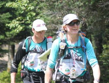
Our route started to head cross-country and our navigation went well but we kept hitting nasty stretches of bushwhacking - open fields of raspberries, logging debris, thick cedars, etc. When we eventually popped out onto the gravel road leading to Magalloway Mountain, we met Luis Moreira who told us that Granite was in 1st place two minutes ahead of us on the road, and Skandia was a few minutes behind us, having gained almost an hour on both Granite and us in this section.
We were short of both water and water purification pills at this point, so our priority was finding a decent-looking stream before we climbed to the summit. We couldn't afford to worry about Skandia passing us, which they did shortly after we stopped at a stream. The climb up Magalloway Mountain was on trail but the taxpayers certainly saved a lot of money by not building switchbacks! Friendly volunteers surrounded us at the top and let us know that some CPs had been removed from the course.
All of us had a few hot spots, so we had previously decided to air our feet out for 10 minutes up here. As it turned out, this gave us a chance to plan our new routes for the revised trek. This photo shows my lovely feet which actually were - and remained - the least damaged of anyone on the team.
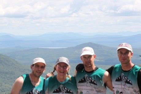
There was a mandatory team photo at a scenic overlook. We're in 3rd place in this pic and very happy to be there!
Because of where we needed to go next, the trail down Magalloway Mountain didn't make much sense. However, the mountain was steep on all sides and too cliffy to descend on the east side, where we actually needed to go. We opted to head down the north side and contour around as soon as we got past the cliffs. Although it took us a little out of our way, this was the closest access to the main road we wanted to hit when we reached the bottom.
If we thought the bushwhacking was bad before, it's only because we hadn't been here yet. Holy crap! We were on slopes so steep that we were skidding downhill and grasping at saplings whenever we hit an open chute. However, that wasn't very often. Mostly, we were tearing branches apart and stepping over logs onto lower ground that we couldn't see. It was in this section that I gave Kirikou his new nickname, the Bush Whisperer. He can fly through tough bush and is great at weaving together little sections where the going is easier.
That's why he was in front when we heard a crashing sound. The largest moose any of us had ever seen leapt to his feet, angry to be roused from his afternoon nap. (This photo is not our moose - it's one that the course testers saw.) He was glaring at Kirikou. All of us were eyeing trees and thick bush nearby in case the moose charged, grateful that trampling Kirikou would slow the moose down a little before he reached the rest of us. ;-)
The moose stared at us for what seemed like an eternity then decided we weren't worth the trouble. He trotted off and we all exhaled. After finishing the descent off the mountain through thick bush, we were rewarded by a sloppy slog through marshy land and stream vegetation and thigh-deep dunks in mud before reaching the gravel road. We were doing less running and more speed-hiking at this point since we'd drained some energy reserves in today's tough bushwhacking. We probably weren't drinking as much as we should because we were conserving our water purification pills and weren't keen to drink untreated water. I hooked onto the ever-helpful Relentless' tow line since that kept me alongside the boys without needing to focus too much.
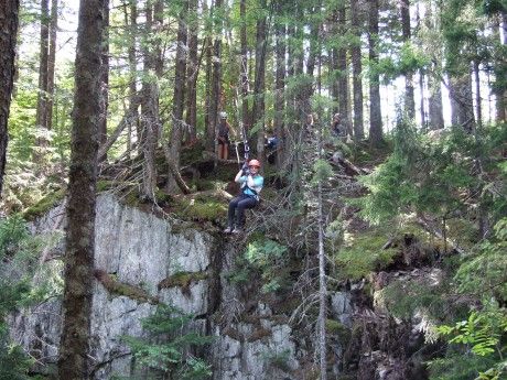
We got to the ropes section at Garfield Falls about 1 km after several of us shared a hallucination of a sign pointing to the falls. (It was just a few tree branches and some leaves but we were convinced!) There was a Tyrolean Traverse, a rappel and a bit of stream walking before we climbed back up to where we'd left our packs.
We were the third team to do the ropes, which took about 20-25 minutes. Shortly after our departure, we met a couple of teams coming in, including Team GUATS, who were still doing a fine AR shuffle.
We stopped to purify water where we crossed the river, then headed toward CP22 in late afternoon sunlight. We ran slowly on flats and downhills, knowing that things would slow down soon and we wanted to get most of the trek done before we lost our light. We started in along a trail by a creek. In some places it was OK but it clearly hadn't been travelled in some time. We were heading behind the peak of Stub Mountain and it seemed like we might be too far on the other side of the valley, so we headed over that direction more. According to GUATS, it would have been quicker to stay near the indistinct trail since it got better from time to time. We bushwhacked steadily toward the head of the valley but it was slow going. As we got close to the top near the lake we were heading for, the bushwhacking got exceptionally difficult. There were times we simply couldn't move forward yet we didn't want to get off our bearing too much in case it got dark before we found the little lake behind the peak. We hit a trail shortly before the lake and had an easy walk down to the shore. Kirikou and I generously volunteered to walk along the shallows at the edge of the lake, peering into the forest to look for the flag. (This was hardly necessary but the cold water felt soooo good on our feet.) Relentless and Harps stayed onshore and found the flag.
Looking ahead to CP23, the final summit on the trek, it seemed obvious that we should get there via a ridge walk similar to ones that I've done in many rogaines in the past. It's usually fairly easy to stay close to the high point of a ridge in the dark, particularly if it's narrow and you're careful about pace counting, compass bearing, etc. So our first step was to return to the saddle. It wasn't far but it made all our other bushwhacking today - maybe all the other bushwhacking in our *lives* - look like child's play. It was dark now so we had little peripheral vision. I plunged over a couple of small cliffs and balanced on fallen trees, some of which collapsed and hurtled me into the unknown while others simply scratched me and tore my clothing. It was rare that we could see where we were putting our feet, so we were risking injury with every step. When the altimeter told us that we'd reached the saddle, I called a halt so we could re-evaluate our strategy. The ridge walk simply wasn't going to work. There had to be another way.
I've rarely used an altimeter in AR but it saved our butt this time and I will need to start using one. Using an idea from our ever-creative navigator Harps, we decided to descend about 600' to the 2600' contour, then follow it east until the ground rose to the ridge that we wanted. We could only hope that the terrain down there was faster going than the ridge, since we were adding significant descent and climb to our route. Luckily, it worked out that way.
This section was a full team effort. Relentless kept track of timing. Harps watched the altimeter like a hawk. Kirikou found ways through the bush on an accurate bearing. I watched the map and the bearing and confirmed that all the readings together were making sense and that the terrain was doing what we expected it to do at the time we were expecting it to happen. Coming from an outside team, I was impressed at how smoothly we worked together here and throughout the race without spending a bunch of time debating how to do it. I think this is why we did better at Untamed than most people, including us, expected.
Kirikou led us along a new bearing at the top of the ridge while Harps took altimeter readings. Unfortunately, we stopped short at a false summit near our CP, which meant we did some scrambling around to search for the highest point. It was here that the skin slid off the bottom of Relentless' toe so we had an emergency first aid break. Relentless is a strong workhorse and never complains but the pain must have been excruciating, especially in that bush. The rest of us didn't realize it yet but Harps' feet were turning raw as well, so both guys were soldiering through serious pain in some of the nastiest bush any of us had ever experienced. After nabbing CP23, we had a steep 2 km descent to reach a road. Kirikou led the way and there were some steep sections once again. I had a couple of impressive falls, managing to smash my hip and twist my ankle. I didn't want to complain though because at least my feet still had skin on them!
At last we hit the road near Bosebuck Camp (TA3/TA4/TA5) and did a steady uphill climb for a couple of kms. The next legs were loops from this camp so we knew we'd be seeing this hill again. We arrived at 2:44 a.m. in 4th place behind GUATS (who had an amazing trek), Skandia and Granite. We had planned to prepare for the next leg before taking a 2-hour nap but we were just too fried. We got the UTMs for the bike section, had some food, set up our sleeping bags and did some foot care. I wasn't tremendously effective here. I was in a fatigued state where I became paralyzed by indecision. Will we sleep well in the communal tent or should we sleep on our tarp? Should I use the Primus stoves to make some hot food or just gobble down a cold can of Beefaroni? Is it most important to take off my shoes right now and air my feet? If I take off my shoes, will I be able to get over to that tent where we're going to sleep? If I want dry socks for the next leg, do I need to leave my wet socks on in case I need to put my shoes on? Should I look for my bike and make sure it's OK? How much stuff should I get ready for the next leg so I don't hold the team up after our nap? It all seems silly and obvious now, and it's not as bad as it sounds because I was the second to get to bed. However, I didn't get any hot food, which would have been nice before a chilly 2-hour nap. I need to figure out how to get better at handling TAs when I'm super-tired.
Mmm, gotta say that nap from 3:15-5:15 a.m. was amazing!!