Training Log Archive: PGIn the 7 days ending Dec 9, 2012:
| |||||||||||||||||||||||||||||||||||||||||||||||||||||||||||||||||||||||||||||||
| « | » |
| » now | ||||||||||
| Mo | Tu | We | Th | Fr | Sa | Su | |||||||
Sunday Dec 9, 2012 #
Note
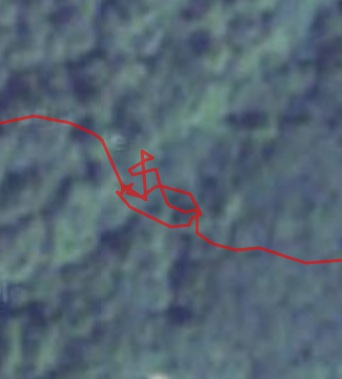
My route from yesterday (click maps for larger versions) --
Overall:
QR.jpg)
Bigger version of the first map, which was actually a pretty good map:
QR.jpg)
Overall:
Bigger version of the first map, which was actually a pretty good map:
9 AM
Note
Here's Ben Gallup's merging of the four maps from yesterday. I'll get my routes done when I get home.
Meanwhile, before I forgot, a few details on what, after further reflection, is some of the worst orienteering I have done in a long time.... :-)
1. It started roughly a hour and twenty minutes in, at control #30. Spiked it nicely, and then lost 4 minutes on it? How is that possible? Well, the first two minutes were at the control looking for the punch. Looked all over, couldn't find, finally moved on, which meant carefully and slowly crossing the stream on a fallen log and climbing the steep bank on the other side.
At which point another team arrived at the control. I called back that there was no punch. About 5 seconds later they called back, yes, there is.
Back down the bank, across the log. There was the punch, right at the top of the control stand, just where they always are. I had been looking for one attached by a string....
4 minutes gone.
2. Leaving #37 (just south of the ball field, by km 13), heading for 34 (by km 14.75), obviously forgot to look at my compass, headed north instead of east. Fortunately the map had road names on it, so I eventually discover my error.
So picked up 35 (by km 14) on the way, though it would have been much easier to get that after 38.
A couple more minutes.
3. Route from 36 (by km point 15.75) to 44 (up by the ball fields), should have take the right route (like Ben), roads all the way, took a "trail" marked on the map, lots of new buildings, got screwed up royally, another 3 or 4 minutes.
4. Ah, control 44. By the left-field fence of the northeastern baseball field. Went to the northeastern field, no control, looked all around both fields, finally moved on, 6 minutes gone.

5. Missed the next control some, but there were terrible briers.... But saw a team there and they had found 44. WTF. No way I wanted to go back through the briers.
Got to 45 and 43, saw another team, they'd also found 44, said there were more than two baseball fields. So I went back, as it was a 3-point control (most were just 1-point). Yup, two more fields, the control was on the northeastern of those two fields (which were SE of the other two fields). Bad luck? Stupid? Some of both?
Another 10 minutes gone.
6. Next control, in the middle of town. misread the streets, another two minutes.
Now 3 hours in. Just about 30 minutes shot in the last hour and forty. Unreal.
And then perfect the rest of the way.
Meanwhile, before I forgot, a few details on what, after further reflection, is some of the worst orienteering I have done in a long time.... :-)
1. It started roughly a hour and twenty minutes in, at control #30. Spiked it nicely, and then lost 4 minutes on it? How is that possible? Well, the first two minutes were at the control looking for the punch. Looked all over, couldn't find, finally moved on, which meant carefully and slowly crossing the stream on a fallen log and climbing the steep bank on the other side.
At which point another team arrived at the control. I called back that there was no punch. About 5 seconds later they called back, yes, there is.
Back down the bank, across the log. There was the punch, right at the top of the control stand, just where they always are. I had been looking for one attached by a string....
4 minutes gone.
2. Leaving #37 (just south of the ball field, by km 13), heading for 34 (by km 14.75), obviously forgot to look at my compass, headed north instead of east. Fortunately the map had road names on it, so I eventually discover my error.
So picked up 35 (by km 14) on the way, though it would have been much easier to get that after 38.
A couple more minutes.
3. Route from 36 (by km point 15.75) to 44 (up by the ball fields), should have take the right route (like Ben), roads all the way, took a "trail" marked on the map, lots of new buildings, got screwed up royally, another 3 or 4 minutes.
4. Ah, control 44. By the left-field fence of the northeastern baseball field. Went to the northeastern field, no control, looked all around both fields, finally moved on, 6 minutes gone.
5. Missed the next control some, but there were terrible briers.... But saw a team there and they had found 44. WTF. No way I wanted to go back through the briers.
Got to 45 and 43, saw another team, they'd also found 44, said there were more than two baseball fields. So I went back, as it was a 3-point control (most were just 1-point). Yup, two more fields, the control was on the northeastern of those two fields (which were SE of the other two fields). Bad luck? Stupid? Some of both?
Another 10 minutes gone.
6. Next control, in the middle of town. misread the streets, another two minutes.
Now 3 hours in. Just about 30 minutes shot in the last hour and forty. Unreal.
And then perfect the rest of the way.
C • 2
C • #46 1
Saturday Dec 8, 2012 #
Event: RHINO 5
Event: Dover Raid Adventure Race
11 AM
orienteering 4:46:16 20.9 mi (13:42 / mi) +1319ft 12:55 / mi
ahr:140 max:177 shoes: mizuno
Dover 5.5 Hour Score O'. Rainy and about 40F. Quit early on purpose, got 38 out of 45 controls. Totally delighted with the outing, other than a couple of dumb-ass moves that cost me the better part of 30 minutes Legs felt good pretty much the whole way.. And even managed to get the tent erected, though not without some extra advice from the girl.
Now at Charlie's. Odds of doing the RHINO are between 0 and 10%, closer to the former...:-)
Now at Charlie's. Odds of doing the RHINO are between 0 and 10%, closer to the former...:-)
Friday Dec 7, 2012 #
Note
I seem to be doing this tomorrow, plus this.
Who knows what the first one will be like, what sort of fun and games will be involved aside from normal orienteering. And what the maps will be like. Need to get things figured out tonight as far as what to take, especially what to carry in the way of food and drink. I tend to prefer going light. Maybe just take some money?
And a way to deal with a punch card of unknown size. And a writing instrument that works when it's wet, and that I won't lose. And some cold rain. And who knows what else.
Ambitions? The only thing I can think of is distance, would be nice to go at least 15 miles. I'm not planning on staying the whole time, 3 or 4 hours at the most. So also no need for a light. But that makes it hard to feel too ambitious/serious if you're already planning to quit early.
Whatever. Hope there's some adventure.
As far as RHINO, would be really cool to not be so battered by Dover that I actually felt like a little night-O.
Wednesday Dec 5, 2012 #
2 PM
trail running 32:52 3.09 mi (10:39 / mi) +413ft 9:27 / mi
ahr:129 max:146 weight:142lbs shoes: mizuno
Zero energy. Started to head up Mt. Toby, but it clearly wasn't going to happen. I think it's time for a day r two off.
Tuesday Dec 4, 2012 #
Note
The IRS is cracking down. You now have to pass an exam to be a tax preparer. So I took it today and passed. :-)
3 PM
road running 53:20 6.28 mi (8:30 / mi) +23ft 8:28 / mi
ahr:133 max:145 weight:142.5lbs shoes: mizuno
At the Holyoke reservoirs, just putting in a few miles (6 miles seems like a long ways these days).
Entertainment from This American Life about the Indian wars (i.e. the white newly-arrived Americans trying to get the land occupied by the native Americans) in southern Minnesota in 1862. I always though Minnesotans were reasonably peaceful (with the exception of the folks in "Fargo"), but I guess that wasn't always so.
Trouble hanging with the show for the first 30 minutes, but then it got better and better. Including a bit about how the Minnesota state flag showing an indian riding a horse is really representing the Indians being chased out of the star. And also quite a bit about our propensity to forget many inconvenient facts in our history.
Monday Dec 3, 2012 #
Note
Much too close to the eye for comfort, but not nearly as bad this time as when I did the full Cyclops treatment seven years ago.
Note
Routes and a few comments from last weekend's courses (click on maps for larger version) --
Night-O (Brown course)
#2. Took a short trail detour because I was worried that going straight would be hard to know if I was right or left if I missed.
#4. Thought about going around to the left, might well have been better.
#5. Seems like a lot of extra distance, but I was moving a lot faster on the roads and fields so I think it was better.
#7. Quite confused when I got to the last field, just uncertain, probably an extra 30 seconds trying to be sure.
#10. Scary point, felt like I was too low and I was.
#11. Thought I was being careful with the direction, but I wasn't.
But overall, for night-O, good for me, ran quite a bit and no big errors.
QR.jpg)
Relay (Yellow course)
#6. Route shown is a little off. Ran road along fence, then along yellow and last bit through thicker woods. Never saw that the trail went right to it, should have hopped on it up top.
#10. Through the tunnel and along the trail would have been much quicker.
Overall OK, main thing was not to do anything stupid, like mispunch or skip a control or take them in the wrong order, all easy to do. I was quite careful to be sure I was getting them all in the correct order.
QR.jpg)
Ultralong (Green course)
#1. Shaky start. Didn't really know where I was. Route shown is a little off, got to the trail before the bends, saw the reentrant to my right and finally knew where I was. And then ran right past my reentrant, following a couple others to the red control further along.
#3. Not sure about route, I crossed reentrant partway and another before the control, maybe around to the right was better both times?
#4. Way off. But there is no good way to attack, so plan was to just head over and if I didn't happen to see it, then relocate on the various detail near or beyond the point. Way to the right, so when I hit a nice reentrent misidentified it and went east, very lucky to hit the trail. Control was then easy, in the back door.
#6. Scary control. Trying to go due south and see if I could identify anything. Thought I saw the patch of yellow, never saw the blue, but did see a fence post along a line of trees heading SE and figured that was the fence just before the control. Looked like a little thicker vegetation NE of the "fence." Lucky, but also good at picking up what clues there were.
#7. Another scary one. Had the feeling I was too far left at the end, so trying to correct to the right, did it just enough to see the control ahead of me.
#8. Sloppy on compass again leaving 7. And then the last bit, I think it was better to go around the whole reentrant, though it never occurred to me at the time.
#10. Not bad, missed all but one reentrant. It looks minimal, but it was nasty.
#11. Should have gone around to the left. Lots of greenbrier in the vertical green area, got my face there.
#12. Better compass, both leaving 11 to the trail, and approaching 12.
#13. Just trying to get to the road, nasty at the end.
Overall, better after #4. Some questionable routes and bearing, but reading the terrain well and avoiding any big misses. Very glad to be done.
QR.jpg)
Night-O (Brown course)
#2. Took a short trail detour because I was worried that going straight would be hard to know if I was right or left if I missed.
#4. Thought about going around to the left, might well have been better.
#5. Seems like a lot of extra distance, but I was moving a lot faster on the roads and fields so I think it was better.
#7. Quite confused when I got to the last field, just uncertain, probably an extra 30 seconds trying to be sure.
#10. Scary point, felt like I was too low and I was.
#11. Thought I was being careful with the direction, but I wasn't.
But overall, for night-O, good for me, ran quite a bit and no big errors.
Relay (Yellow course)
#6. Route shown is a little off. Ran road along fence, then along yellow and last bit through thicker woods. Never saw that the trail went right to it, should have hopped on it up top.
#10. Through the tunnel and along the trail would have been much quicker.
Overall OK, main thing was not to do anything stupid, like mispunch or skip a control or take them in the wrong order, all easy to do. I was quite careful to be sure I was getting them all in the correct order.
Ultralong (Green course)
#1. Shaky start. Didn't really know where I was. Route shown is a little off, got to the trail before the bends, saw the reentrant to my right and finally knew where I was. And then ran right past my reentrant, following a couple others to the red control further along.
#3. Not sure about route, I crossed reentrant partway and another before the control, maybe around to the right was better both times?
#4. Way off. But there is no good way to attack, so plan was to just head over and if I didn't happen to see it, then relocate on the various detail near or beyond the point. Way to the right, so when I hit a nice reentrent misidentified it and went east, very lucky to hit the trail. Control was then easy, in the back door.
#6. Scary control. Trying to go due south and see if I could identify anything. Thought I saw the patch of yellow, never saw the blue, but did see a fence post along a line of trees heading SE and figured that was the fence just before the control. Looked like a little thicker vegetation NE of the "fence." Lucky, but also good at picking up what clues there were.
#7. Another scary one. Had the feeling I was too far left at the end, so trying to correct to the right, did it just enough to see the control ahead of me.
#8. Sloppy on compass again leaving 7. And then the last bit, I think it was better to go around the whole reentrant, though it never occurred to me at the time.
#10. Not bad, missed all but one reentrant. It looks minimal, but it was nasty.
#11. Should have gone around to the left. Lots of greenbrier in the vertical green area, got my face there.
#12. Better compass, both leaving 11 to the trail, and approaching 12.
#13. Just trying to get to the road, nasty at the end.
Overall, better after #4. Some questionable routes and bearing, but reading the terrain well and avoiding any big misses. Very glad to be done.
12 PM
trail running 33:44 3.75 mi (9:00 / mi) +187ft 8:35 / mi
ahr:134 max:149 shoes: mizuno
Stopped in Holyoke on the way home for a loop around the Mountain Street reservoir. Felt like a struggle, but legs were at least able to do it without any pain.