Training Log Archive: PGIn the 7 days ending May 24, 2009:
| |||||||||||||||||||||||||||||||||||||||||||||||||||||||||||||||||||||||||||||||||||||||||||||||||||||||||
| « | » |
| » now | ||||||||||
| Mo | Tu | We | Th | Fr | Sa | Su | |||||||
Sunday May 24, 2009 #
Event: Club Champs Return to Mt Tom
orienteering 52:28 [3] 5.3 km (9:54 / km) +7080ft 3:16 / km
rhr:51 slept:8.0 weight:133.5lbs
NEOC 2008 club champs at Mt. Tom. Yup, 2008, but better late than never. The meet popped up on the schedule just recently, courses by Samantha, meet organized by Jeff and Judy, a pleasure to have one just down the road, well, maybe 25 minutes, but that seems real close.
I was thinking this could be my first go at a Brown course, M65, but then it being the 2008 champs, and I was 64 (O' age) then, M60 and green it was. That seemed more than enough as I was still a little battered and weary from yesterday.
Orienteered so-so, ran so-so. Or maybe it's more accurate to say they both started out pretty well, but then the running went downhill when the course went uphill, whereas the orienteering went downhill only when the course finally went back downhill. Ran well until #4, orienteered well until #10.
It's funny, I was thinking on the ride over that I should try to pick the pace up, just to get back the feeling of moving quicker through the forest and the stress that adds. Of course, picking the pace up for the whole course wasn't possible, so the idea was to try on some individual legs. Good idea, except I forgot. At least until I saw Carl Childs just ahead of me at 11. And then I shifted up a gear (it help that it was seriously downhill), and nailed 12 and 15 at a good rate of speed. That would sound like a success, except I diddled around to both 13 and 14, losing anything I might have gained by running faster. Got to do both, run and think, but at least better to have tried, to remember what it's like to start moving again. Need to work on this a bunch.
Quite beat by the end, dripping wet (mostly sweat....). Still way too warm for my tastes, about 80F, and summer is just starting. 5 down, 45 to go.
.jpg)
Larger version.
I was thinking this could be my first go at a Brown course, M65, but then it being the 2008 champs, and I was 64 (O' age) then, M60 and green it was. That seemed more than enough as I was still a little battered and weary from yesterday.
Orienteered so-so, ran so-so. Or maybe it's more accurate to say they both started out pretty well, but then the running went downhill when the course went uphill, whereas the orienteering went downhill only when the course finally went back downhill. Ran well until #4, orienteered well until #10.
It's funny, I was thinking on the ride over that I should try to pick the pace up, just to get back the feeling of moving quicker through the forest and the stress that adds. Of course, picking the pace up for the whole course wasn't possible, so the idea was to try on some individual legs. Good idea, except I forgot. At least until I saw Carl Childs just ahead of me at 11. And then I shifted up a gear (it help that it was seriously downhill), and nailed 12 and 15 at a good rate of speed. That would sound like a success, except I diddled around to both 13 and 14, losing anything I might have gained by running faster. Got to do both, run and think, but at least better to have tried, to remember what it's like to start moving again. Need to work on this a bunch.
Quite beat by the end, dripping wet (mostly sweat....). Still way too warm for my tastes, about 80F, and summer is just starting. 5 down, 45 to go.
Larger version.
.jpg)
orienteering 45:00 [1]
Picking up some controls, all at a walk.
Note
Entered the Swiss O Week. Looking more likely for Oringen too but not yet decided (need to in the next few days).
The initial challenge will be to do the harder training without getting hurt, finding the right balance. At least the G is doing well, still trending slightly down. That has to be part of the package.
The initial challenge will be to do the harder training without getting hurt, finding the right balance. At least the G is doing well, still trending slightly down. That has to be part of the package.
C • Cool 1
Saturday May 23, 2009 #
orienteering 58:26 [3] 6.85 km (8:32 / km) +755ft 7:18 / km
weight:133.5lbs
Still dehydrated.
WCOC local meet at Ansonia, hosted by Greg and Sergei and Kseniya. Just excellent. Ansonia is such a sweet place even with the leaves up, and those guys always set good courses and today was no exception.
Today's menu was the normal selection of courses through Red, plus a course that was called a sprint but Greg was quick to add, felt more like a short middle.
.jpg)
I opted for the Red first, thinking if I did the sprint first, then the Red would be with dead legs all the way, as opposed to maybe only part of the way under this plan. And that's about how it turned out. Slowly got tired, more walking especially on the long leg heading south. But my navigating was excellent, and the running wasn't too bad for quite a while. So overall a good run, progress, though where I want to be in 8 weeks would have me doing the course 4 or 5 minutes faster. Maybe I'll figure out a way to justify going down there in a month or so to have another go at it.
Larger version of red course.
WCOC local meet at Ansonia, hosted by Greg and Sergei and Kseniya. Just excellent. Ansonia is such a sweet place even with the leaves up, and those guys always set good courses and today was no exception.
Today's menu was the normal selection of courses through Red, plus a course that was called a sprint but Greg was quick to add, felt more like a short middle.
I opted for the Red first, thinking if I did the sprint first, then the Red would be with dead legs all the way, as opposed to maybe only part of the way under this plan. And that's about how it turned out. Slowly got tired, more walking especially on the long leg heading south. But my navigating was excellent, and the running wasn't too bad for quite a while. So overall a good run, progress, though where I want to be in 8 weeks would have me doing the course 4 or 5 minutes faster. Maybe I'll figure out a way to justify going down there in a month or so to have another go at it.
Larger version of red course.
.jpg)
orienteering 24:07 [3] 2.5 km (9:39 / km) +394ft 7:47 / km
And then the "sprint." Certainly not running at a sprint pace, the legs feeling the previous effort, more walking up hills than I would have cared for, and not really pushing the mental effort, but still OK. Navigating was again good, just a couple of cases of coming down a slope and expecting to drop right on to the control and being 20-30 meters off. One case I saw it right away, the other I had to scratch my head for a bit.
.jpg)
Another fine course. Larger version.
4 good workouts done, 46 to go.
Another fine course. Larger version.
.jpg)
4 good workouts done, 46 to go.
trail running 5:00 [2] 0.5 mi (10:00 / mi)
A little warm-up. Helped, should have done 10 minutes.
Drove down and back with Phil, very pleasant. Good friends are priceless.
Drove down and back with Phil, very pleasant. Good friends are priceless.
Friday May 22, 2009 #
Note
weight:134lbs
One of the joys of orienteering overseas (or trying to plan to go overseas) is the imaginative use the English language is put to. From the web site of a 5-day event in Spain in August --
"All categories in official tests using the system Sportident.
In the Open category will be allowed the use of a card classic.
Some of the careers of classical antioficial be with tweezers."
That third line, say what?
"All categories in official tests using the system Sportident.
In the Open category will be allowed the use of a card classic.
Some of the careers of classical antioficial be with tweezers."
That third line, say what?
Note
Of course sometimes the English is very clear, as in this bit about the Swiss 6-Day:
"The walk from the assembly area to the start will take between about 5 and 50 minutes. The finish is at the assembly area. There is an exception for classes from start 1 and 2 that run day 3 on the Glattalp (see courses): walk from assembly area to and from start & finish: 4.5km with 700 m height difference."
A 4.5km walk to S/F with 700m climb, and then back down after the finish. They don't kid around.
So should I feel glad that H65 is on a lower (and less interesting) map, whereas H60 and younger get to climb, or annoyed that I'd miss out on the special terrain?
Since the next day is a rest day, I suppose I could always hike up that afternoon and have a look.
If we go to Switzerland....
biking 48:45 [3] 13.6 mi (3:35 / mi)
Hot, about 90, got out the bike for a short ride, South Deerfield and Whately. Definitely hot.
Thursday May 21, 2009 #
Note
weight:134lbs
Dehydrated this morning.
I took a look at our rogaine route a couple of ways in Gmaps-pedometer. Here's how we actually went, distance covered was 63.8 km. I supposed what we really went would be 5% more (?) because we're not goes exactly straight even when we are trying to.
And here's as the crow flies, 53.4 km. Actually not as much different as I would have guessed given all the serpentine canyon walks.
Time moving was about 19 hours.
track 20:00 [4] 4.8 km (4:10 / km)
I was thinking of going down to run the Holyoke 5K XC, but it was very warm (upper 80s) and I remembered that there is also a track group on Thursday evenings, and that seemed to make more sense, easier to back off or cut it short.
The group was running 2x400, then 4x800, then 2x400, all with fairly short rests. I figured I'd see if I could do the 400s in 1:45 and the 800s in 3:30. Actually was a little quicker, but also working perhaps a little too hard. But I made it all the way.
400: 98.7, 51 rest
400: 98.9, 60 rest
800: 3:19.4, 71 rest
800: 3:24.0, 67 rest
800: 3:23.1, 66 rest
800: 3:22.5, 69 rest
400: 95.8, 56 rest
400: 97.5
The fine splits provided by an old watch of Gail's I borrowed, an Ironman women's model (is there an Ironwoman's model?). Seemed to work OK.
track 8:30 [2] 1.6 km (5:19 / km)
A little before, a little after, plus a lengthy leisurely walk after.
So, if I have 2 months to get fit, 60 days, then that means at least 50 decent running workouts. 2 down (yesterday counts given the heat, lack of sleep, and recent rogaine, meaning that it was an appropriate amount of stress to the system), 48 to go.
I'm wondering if I should get a toy (one of the Forerunners gizmos) to help with the motivation?
Note
Cultural observations from the Phoenix airport --
They have big signs outside proclaiming it to be the World's Friendliest Airport. After getting checked in and through security, I pulled out my laptop to see what sort of service they were offering and what the charge was to hook up for an hour. What a pleasant surprise -- free wi-fi, all you had to do was answer a question:
Would you say Phoenix is
a. The World Friendliest Airport
b. Pretty friendly
c. Well, I didn't even bother with c and d, I think d was "unfriendly", because any place that makes it so easy to log on is definitely friendly. I checked a and moved on.
There was also time for a beer (Barb's idea!) and some nachos (also her idea, but since it was mid-afternoon and all I'd had to eat was a bowl of granola many hours earlier, I had more than my share of the nachos, and they really really tasted good), but we were both offered, and passed on, a shot on the side. Is this standard practice? Does it taste really good too? Do they have a service to carry you onto the plane. I have no answers. Clearly, more research is needed.
Wednesday May 20, 2009 #
Note
weight:135.5lbs
Read Unaccustomed Earth on the trip. A really wonderful, wonderful book, actually a collection of stories about relationships. Brought many smiles, a few tears.
C • book 2
Note
Time to get serious thinking about summer plans. At the rogaine I was talking about it a little with Bash, and I remember making the following distinction -- that orienteering when you are fit is a different sport then when you are not fit.
When you are fit, when your running can keep up to your navigating, then there is a sense of urgency about everything, and there is a constant struggle to be up to the challenge of moving accurately and fast. Whereas when you are less fit, and you don't see a hill you can't walk, then that sense of urgency disappears, the mental challenge changes completely (mostly disappears), and everything is a whole lot easier.
For orienteering in Europe, long trip, time, expense, I want to be fit, at least by the standards of M65. I want to feel like I'm ready to race, not just to finish. So the question is, am I there? And the answer, obviously, is no, not yet, though there has been progress. And so the next question is, will I be there in 2 months? And the answer is, possibly, much work would need to be done.
And maybe the way to get that work done is to set the goal -- tickets, entries, etc. And then see if it can be done.
Nothing ventured, nothing gained.
trail running 1:11:40 [3] 7.2 mi (9:57 / mi)
With Phil from the Amethyst Brook parking area, south on the Frost to Station Road and back. 36:28 out, 35:12 back.
Upper 70s, felt warmer, pleased to get out and run for 70 minutes even if it was a struggle. Legs not so bad, taped up the worst of the blisters.
Spotted a pair of pileated woodpeckers. And 2 ticks, one large and one small, so far....
Upper 70s, felt warmer, pleased to get out and run for 70 minutes even if it was a struggle. Legs not so bad, taped up the worst of the blisters.
Spotted a pair of pileated woodpeckers. And 2 ticks, one large and one small, so far....
Tuesday May 19, 2009 #
Note
Scanned the rogaine map, easier to read. I'll write something up later, but I think I need a nap, or a shower, or some exercise first, or maybe all three.
Quick inventory -- blisters on three toes of right foot, none terrible; upper left calf has a sore spot, also a muscle on the inside of the quad, runs from the groin to the knee, neither bad, just surprising that neither hurt during the event at all. No sunburn due to use of large amounts of sunscreen. About 12 hours cumulative sleep deficit. Quite a few less brain cells. And certainly ready to rogaine again, these things really are fun.
.jpg)
Quick inventory -- blisters on three toes of right foot, none terrible; upper left calf has a sore spot, also a muscle on the inside of the quad, runs from the groin to the knee, neither bad, just surprising that neither hurt during the event at all. No sunburn due to use of large amounts of sunscreen. About 12 hours cumulative sleep deficit. Quite a few less brain cells. And certainly ready to rogaine again, these things really are fun.
Note
A tour around the course, or at least our route....
Overall strategy -- work as a team, communicate, have fun. We had a bunch of discussion and analysis of various routes, whether to head west or not into the big canyons, where it turns out most people went. Decided that our route was better, several more controls to get for a similar number of points, but not the big climbs/drops.

40. By the "tank" (a dried-up dammed-up pond), just left of the top of the big reentrant, and down, looking for the side reentrant. There was another one before the correct one, just the same size at the correct one, so one wasn't shown on the map at all and the other was shown too large. Good practice training the eye, and a reminder of the flexibility needed. Always on the compass too, the whole time we were out there, no matter what. I would guess I checked my compass on average at least every 30 seconds over the course of the 22 hours we were out.
All needed a reminder, repeated on the the next couple of controls, to keep communicating. Had to get back in rogaine mode.
30. Straight to the big reentrant, staying just slightly right of the line. We weren't sure how high the control would be, turned out a bit higher than I expected. That's not to say it was wrong. With a 1:30,000 map, everything was usually a little further than expected. Or maybe it was just the anxiety, wanting the confirmation you're right.
71. Your basic canyon bottom walk -- keep track of all the turns and always check the compass, get to the correct side canyon, go up to the control. Same operation, day or night. Easy. And given the steep slopes, no other option.
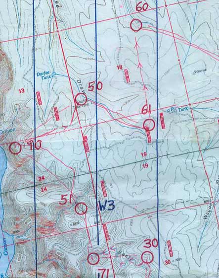
51. Tougher, plus I was being sloppy. Route across the slope was just a little too high to get a good view of the flat spur to the left, plus wasn't pacing. So there was uncertainty as we got close, but either Barb or Cristina had it figured out.
90. Some discussion of back up out of 51 and around to the right, but down and up instead. Then by the top of 3 reentrants, out the spur, down until it got steep. We were just to the right, maybe 50 meters. Nice view of the western terrain.
50. Back up. Not much of a climb. At the top Barb said her pulse was about 150 and she looked flushed. Checked mine, 96. The first sign her system was going screwy, and the pace so far had been mellow. Not good. Then across some bland terrain, picked up the E/W trail which simplified matters. First of many breaks, for Cristina to adjust shoes. No complaints from anyone about stopping. This section of the map, blander and flatter terrain, was the toughest, better to be doing it in the daytime.
61. Basic canyon walk, a very shallow "canyon" but very well defined.
60. Straight compass, partly for the lack of a better alternative, partly just for the challenge. Execution was perfect, plus all the little changes in the contours along the way made sense. Also benefited from having all the fingers crossed. Cristina was impressed.

80. Toughest leg (60 had an easier recovery if you missed). Straight compass. Perfect, hit the reentrant maybe 100 meters above the control but the reentrant seemed small and, thinking it was the smaller one NW of the correct one, we went on. Nothing, turned came back a little lower and there it was.
Difficult because it was a diagonal approach on a gently undulating hillside with not much in the way of distinct features anywhere, and the reentrant turned out less distinct than I expected. You could waste a lot of time here, we probably wasted about 5 minutes. A little annoyed at myself, but only a little as could have done much worse.
52. Straight to the road, then trail, then in, a little careless at the end but no problem. Water stop, another break, Barb feeling worse. The breaks early on were about 10 minutes, then they got longer.

81. Canyon walk, then up to the high ground, over the top, down the left side of the big spur. Nice.
70. Up to skirt the big reentrant, then straight north, canyon walk, and over the small spur at the end.
91. Down to the main canyon, lots of thorns (only really bad vegetation we encountered and I, with just shorts on, was feeling very vulnerable, fortunately B and C found all the openings for me), then up the steep slope. Barb looked like she was feeling awful. I took her fanny pack to help a little. Took another look, she was really suffering, took her camelback too. Not easy, full sun, sure glad it wasn't a 600' climb, and I was sweating like crazy by the top. A bunch of deadfall all along the top, pain in the rear. Coming down the slope towards the end, I thought we might be one reentrant farther right then we were and was hoping to see the control reentrant right ahead of us, but it was clear where we were and not really any time lost. An unpleasant leg.
62. Now for the long trip south. A long canyon walk, interrupted by a break for Barb, also to get filled in on Cristina's life story. Obviously that (the life story) took longer than 10 minutes, but the story entertained us all the way up the canyon. Over the top, another reentrant lined us right up, easy. Ran onto Valeriy and Olga at the control. Did they have anything like Tums? No, but Olga fished out a charcoal capsule for Barb.
82. Up to the trail It was there (you never know), as mapped (again, you never know). To the T (again, as mapped), then down. A brief discussion along the way about whether we were obligated by the rules to report Valeriy and Olga for offering aid to another team.... :-)

64. Up to the trail, but didn't get too far before time for another break. Barb looked even worse. There was a suggestion that she might be better if she threw up, but she seemed reluctant, claiming not to know how to do it. She went off a few meters, made a few puking sounds but no success. Slowly onward to the trail. Pace and reading the subtleties to know where to turn off, no problem.
72. Straight, always reading the terrain too, easy. Getting dark.
46. Canyon walk. Dark at the control. Another break, longer now, maybe 20-25 minutes. Real dark, no moon until after midnight. At some point Barb threw up (fingers down the throat method, though I've never had that do it for me, I think I just keep heaving until something comes up, fortunately it's been a few years since I've had the need).
We sat there a long time. She moaned a lot. Some talk about heading in, would be a long walk. Getting cold, down in a canyon, not moving, shivering, out came the extra clothes. After a while Barb said we should try to keep going. The plan was, we'd stop whenever she wanted, as long as she wanted. Or go in. Either way was OK, you're a team, you stick together.

83. Skipped 45, it was up high and she never would have made it up the canyon wall. Out of the canyon, fortunately an easy climb and Barb was temporarily feeling better, then down to the next one, easy.
74. Headed off, and this is one of situations where you are glad it's not recorded on video tape. I was in front, a little bit east, then a u-turn to the right to continue the canyon walk, except my u-turn was too soon and too sharp and I was heading right back to 83 without knowing it. B and C had stopped. I kept going a little. They yelled. I was stubborn. They yelled some more. I was still stubborn. Finally I turned back, to humor them I remember thinking. And of course they were right, and I was some combination of embarrassed, chagrined, amused, and amazed.
Before long Barb was fading again. Another break, 20 minutes or so. Cold again. She was lying on a sand bar, miserable, got up after a bit, went and threw up some more. Had we a shovel with us we could have put her out of her misery and buried her on the spot, but we didn't.
Strange as it may sound, I was optimistic, we were still moving, still making progress, still getting points. We'd had 1090 by dark. Maybe another 400 in the dark and more in the morning and a decent score was still possible.
Eventually moved on, cold again. More canyon walk, then a very steep but fortunately not too long climb up to 74. Nailed it.

55. Canyon walk. Post-puke, Barb was again doing a little better.
84. Tough climb out of the canyon, but we made it, then compass course for the "g" in "Springs," perfect. Around and up to the control.

56. A break at 84, though now Barb was feeling a little better and we were keeping the breaks to 10 minutes or so.
A major change in route. Cristina was drinking a whole lot more than either of us. Our original route had us going a very long time between water stops, but at night I thought that was OK. It wasn't. So a new plan for a few southern controls and then we'd see how things were when it got light.
Time to go, they headed down, I took a moment to take a caffeine pill, then I stood up to follow, slipped, reached behind me to break the fall, managed to dislodge a football-sized rock as I was sliding down a few feet and it followed me and crunched me on the left forearm. Hurt like hell, but nothing broken, things settled down, and I moved on.
Canyon walk. Checked my watch after about 10 minutes, but it wasn't there. Fuck. Too far to go back even if I knew right where it must be.
69. Straight compass to the water stop. Perfect. I mean, really perfect, hit the road, looked across, and there were the water jugs. Another break, Cristina and me readjusting shoes, re-greasing feet. Someplace in here (probably a little earlier) Barb started to put away a Gu (with caffeine) about every hour, and she was definitely on the mend. But maybe Cristina was getting a little tired/sleepy.
Off again, road to the bend, then compass, easy.
68. Tough control. Combination spur and foot of cliff. Back up over the spur, down the little reentrant so we knew where we were. There was an unmapped road down there, problem is you want to use it, but you also have to map it so you know where you are. Got over in the vicinity on the road, my gut said the control was a little higher. Went up maybe 50 meters, looked around, a couple big (really big) boulders, no controls, thickish forest. Circled around the second, anxiety growing, and just then lit up the reflector a few meters away. Bliss. Called B and C. Onward.
49. Barb definitely doing better. Cristina was hanging in there. I had a few toe blisters but was generally OK. Up to the ridge, trail to the bend, compass across the road and down, easy. Starting to get light.
So Barb had hung in there all night long and we had 530 points in the night despite all the adversity, 1620 so far. 2000 still possible. I didn't have any competitive ambitions for the event, really, honestly, just there for the adventure with friends, but 2000 was a nice round number.
37. Via the water stop. Barb was now in the lead for a few controls, her turn, having followed most of the night. Hit the water stop just right, another break there, maybe 10 minutes, then hit the control, no problem. By now the lights had been stowed away, the birds were singing, life was good.
36. Straight, plus reading the map, perfect.
47. Up and over to the main road. The side road didn't exist, but no problem, compass to the spur, off the end, up to the control. Beautiful woods in the early morning light.

73. Canyon walk, then angled across a slope up to the flat spur just below the control. Perfect route, prettiest spot on the whole course.
34. So break time. Cristina was now getting very tired.
Up the hill, out to the road, a bit of a walk on it and then down to the control.
44. Took the around route. Simple.
35. Another break before leaving 44. Cristina said her hamstrings were starting to go. A quick review of the symptoms, yup, that was it, time to head in, no point in risking serious damage with her on the WOC team. I just hoped she would hold together until we got in.
(And I was also a little bummed, had hoped to go for 4 or 5 more controls, got myself in a bit of a non-communicative snit, far from the first time in my life, would love it if it were the last. So damn counter-productive. OK, PG, repeat after me -- if something is bothering you, say so, don't wait for someone else to try to figure it out and maybe reach some totally wrong conclusion in the process. OK? 100 times on the blackboard? OK?)
Canyon walk to below 35. Another break to rest up for the final assault. Getting hot. Put on more sunscreen (at least I did something right). Then up to the control.
Finish. And in, very slowly, no hurry. 1890 points. Excellent under the circumstances. And I had had an absolutely wonderful time (except for the last little bit....), a couple of absolutely wonderful partners, another adventure, another memory. Though it took me until the next morning to get my head straightened out. Hopefully no damage done. I guess no one ever said life was easy.
And before next time, and I sure hope there is a next time, I'm going to get a light like Cristina has, because it was something else.
Overall strategy -- work as a team, communicate, have fun. We had a bunch of discussion and analysis of various routes, whether to head west or not into the big canyons, where it turns out most people went. Decided that our route was better, several more controls to get for a similar number of points, but not the big climbs/drops.
40. By the "tank" (a dried-up dammed-up pond), just left of the top of the big reentrant, and down, looking for the side reentrant. There was another one before the correct one, just the same size at the correct one, so one wasn't shown on the map at all and the other was shown too large. Good practice training the eye, and a reminder of the flexibility needed. Always on the compass too, the whole time we were out there, no matter what. I would guess I checked my compass on average at least every 30 seconds over the course of the 22 hours we were out.
All needed a reminder, repeated on the the next couple of controls, to keep communicating. Had to get back in rogaine mode.
30. Straight to the big reentrant, staying just slightly right of the line. We weren't sure how high the control would be, turned out a bit higher than I expected. That's not to say it was wrong. With a 1:30,000 map, everything was usually a little further than expected. Or maybe it was just the anxiety, wanting the confirmation you're right.
71. Your basic canyon bottom walk -- keep track of all the turns and always check the compass, get to the correct side canyon, go up to the control. Same operation, day or night. Easy. And given the steep slopes, no other option.
51. Tougher, plus I was being sloppy. Route across the slope was just a little too high to get a good view of the flat spur to the left, plus wasn't pacing. So there was uncertainty as we got close, but either Barb or Cristina had it figured out.
90. Some discussion of back up out of 51 and around to the right, but down and up instead. Then by the top of 3 reentrants, out the spur, down until it got steep. We were just to the right, maybe 50 meters. Nice view of the western terrain.
50. Back up. Not much of a climb. At the top Barb said her pulse was about 150 and she looked flushed. Checked mine, 96. The first sign her system was going screwy, and the pace so far had been mellow. Not good. Then across some bland terrain, picked up the E/W trail which simplified matters. First of many breaks, for Cristina to adjust shoes. No complaints from anyone about stopping. This section of the map, blander and flatter terrain, was the toughest, better to be doing it in the daytime.
61. Basic canyon walk, a very shallow "canyon" but very well defined.
60. Straight compass, partly for the lack of a better alternative, partly just for the challenge. Execution was perfect, plus all the little changes in the contours along the way made sense. Also benefited from having all the fingers crossed. Cristina was impressed.
80. Toughest leg (60 had an easier recovery if you missed). Straight compass. Perfect, hit the reentrant maybe 100 meters above the control but the reentrant seemed small and, thinking it was the smaller one NW of the correct one, we went on. Nothing, turned came back a little lower and there it was.
Difficult because it was a diagonal approach on a gently undulating hillside with not much in the way of distinct features anywhere, and the reentrant turned out less distinct than I expected. You could waste a lot of time here, we probably wasted about 5 minutes. A little annoyed at myself, but only a little as could have done much worse.
52. Straight to the road, then trail, then in, a little careless at the end but no problem. Water stop, another break, Barb feeling worse. The breaks early on were about 10 minutes, then they got longer.
81. Canyon walk, then up to the high ground, over the top, down the left side of the big spur. Nice.
70. Up to skirt the big reentrant, then straight north, canyon walk, and over the small spur at the end.
91. Down to the main canyon, lots of thorns (only really bad vegetation we encountered and I, with just shorts on, was feeling very vulnerable, fortunately B and C found all the openings for me), then up the steep slope. Barb looked like she was feeling awful. I took her fanny pack to help a little. Took another look, she was really suffering, took her camelback too. Not easy, full sun, sure glad it wasn't a 600' climb, and I was sweating like crazy by the top. A bunch of deadfall all along the top, pain in the rear. Coming down the slope towards the end, I thought we might be one reentrant farther right then we were and was hoping to see the control reentrant right ahead of us, but it was clear where we were and not really any time lost. An unpleasant leg.
62. Now for the long trip south. A long canyon walk, interrupted by a break for Barb, also to get filled in on Cristina's life story. Obviously that (the life story) took longer than 10 minutes, but the story entertained us all the way up the canyon. Over the top, another reentrant lined us right up, easy. Ran onto Valeriy and Olga at the control. Did they have anything like Tums? No, but Olga fished out a charcoal capsule for Barb.
82. Up to the trail It was there (you never know), as mapped (again, you never know). To the T (again, as mapped), then down. A brief discussion along the way about whether we were obligated by the rules to report Valeriy and Olga for offering aid to another team.... :-)
64. Up to the trail, but didn't get too far before time for another break. Barb looked even worse. There was a suggestion that she might be better if she threw up, but she seemed reluctant, claiming not to know how to do it. She went off a few meters, made a few puking sounds but no success. Slowly onward to the trail. Pace and reading the subtleties to know where to turn off, no problem.
72. Straight, always reading the terrain too, easy. Getting dark.
46. Canyon walk. Dark at the control. Another break, longer now, maybe 20-25 minutes. Real dark, no moon until after midnight. At some point Barb threw up (fingers down the throat method, though I've never had that do it for me, I think I just keep heaving until something comes up, fortunately it's been a few years since I've had the need).
We sat there a long time. She moaned a lot. Some talk about heading in, would be a long walk. Getting cold, down in a canyon, not moving, shivering, out came the extra clothes. After a while Barb said we should try to keep going. The plan was, we'd stop whenever she wanted, as long as she wanted. Or go in. Either way was OK, you're a team, you stick together.
83. Skipped 45, it was up high and she never would have made it up the canyon wall. Out of the canyon, fortunately an easy climb and Barb was temporarily feeling better, then down to the next one, easy.
74. Headed off, and this is one of situations where you are glad it's not recorded on video tape. I was in front, a little bit east, then a u-turn to the right to continue the canyon walk, except my u-turn was too soon and too sharp and I was heading right back to 83 without knowing it. B and C had stopped. I kept going a little. They yelled. I was stubborn. They yelled some more. I was still stubborn. Finally I turned back, to humor them I remember thinking. And of course they were right, and I was some combination of embarrassed, chagrined, amused, and amazed.
Before long Barb was fading again. Another break, 20 minutes or so. Cold again. She was lying on a sand bar, miserable, got up after a bit, went and threw up some more. Had we a shovel with us we could have put her out of her misery and buried her on the spot, but we didn't.
Strange as it may sound, I was optimistic, we were still moving, still making progress, still getting points. We'd had 1090 by dark. Maybe another 400 in the dark and more in the morning and a decent score was still possible.
Eventually moved on, cold again. More canyon walk, then a very steep but fortunately not too long climb up to 74. Nailed it.
55. Canyon walk. Post-puke, Barb was again doing a little better.
84. Tough climb out of the canyon, but we made it, then compass course for the "g" in "Springs," perfect. Around and up to the control.
56. A break at 84, though now Barb was feeling a little better and we were keeping the breaks to 10 minutes or so.
A major change in route. Cristina was drinking a whole lot more than either of us. Our original route had us going a very long time between water stops, but at night I thought that was OK. It wasn't. So a new plan for a few southern controls and then we'd see how things were when it got light.
Time to go, they headed down, I took a moment to take a caffeine pill, then I stood up to follow, slipped, reached behind me to break the fall, managed to dislodge a football-sized rock as I was sliding down a few feet and it followed me and crunched me on the left forearm. Hurt like hell, but nothing broken, things settled down, and I moved on.
Canyon walk. Checked my watch after about 10 minutes, but it wasn't there. Fuck. Too far to go back even if I knew right where it must be.
69. Straight compass to the water stop. Perfect. I mean, really perfect, hit the road, looked across, and there were the water jugs. Another break, Cristina and me readjusting shoes, re-greasing feet. Someplace in here (probably a little earlier) Barb started to put away a Gu (with caffeine) about every hour, and she was definitely on the mend. But maybe Cristina was getting a little tired/sleepy.
Off again, road to the bend, then compass, easy.
68. Tough control. Combination spur and foot of cliff. Back up over the spur, down the little reentrant so we knew where we were. There was an unmapped road down there, problem is you want to use it, but you also have to map it so you know where you are. Got over in the vicinity on the road, my gut said the control was a little higher. Went up maybe 50 meters, looked around, a couple big (really big) boulders, no controls, thickish forest. Circled around the second, anxiety growing, and just then lit up the reflector a few meters away. Bliss. Called B and C. Onward.
49. Barb definitely doing better. Cristina was hanging in there. I had a few toe blisters but was generally OK. Up to the ridge, trail to the bend, compass across the road and down, easy. Starting to get light.
So Barb had hung in there all night long and we had 530 points in the night despite all the adversity, 1620 so far. 2000 still possible. I didn't have any competitive ambitions for the event, really, honestly, just there for the adventure with friends, but 2000 was a nice round number.
37. Via the water stop. Barb was now in the lead for a few controls, her turn, having followed most of the night. Hit the water stop just right, another break there, maybe 10 minutes, then hit the control, no problem. By now the lights had been stowed away, the birds were singing, life was good.
36. Straight, plus reading the map, perfect.
47. Up and over to the main road. The side road didn't exist, but no problem, compass to the spur, off the end, up to the control. Beautiful woods in the early morning light.
73. Canyon walk, then angled across a slope up to the flat spur just below the control. Perfect route, prettiest spot on the whole course.
34. So break time. Cristina was now getting very tired.
Up the hill, out to the road, a bit of a walk on it and then down to the control.
44. Took the around route. Simple.
35. Another break before leaving 44. Cristina said her hamstrings were starting to go. A quick review of the symptoms, yup, that was it, time to head in, no point in risking serious damage with her on the WOC team. I just hoped she would hold together until we got in.
(And I was also a little bummed, had hoped to go for 4 or 5 more controls, got myself in a bit of a non-communicative snit, far from the first time in my life, would love it if it were the last. So damn counter-productive. OK, PG, repeat after me -- if something is bothering you, say so, don't wait for someone else to try to figure it out and maybe reach some totally wrong conclusion in the process. OK? 100 times on the blackboard? OK?)
Canyon walk to below 35. Another break to rest up for the final assault. Getting hot. Put on more sunscreen (at least I did something right). Then up to the control.
Finish. And in, very slowly, no hurry. 1890 points. Excellent under the circumstances. And I had had an absolutely wonderful time (except for the last little bit....), a couple of absolutely wonderful partners, another adventure, another memory. Though it took me until the next morning to get my head straightened out. Hopefully no damage done. I guess no one ever said life was easy.
And before next time, and I sure hope there is a next time, I'm going to get a light like Cristina has, because it was something else.
Monday May 18, 2009 #
Note
Usual disclaimer, this is my log and I can write what I want (and apparently Eddie can too).... :-)
Continuing with my cryptic note from yesterday.
Progress. A lot of thinking and then the unexpectedly useful part, writing down an analysis. Understanding things better, much less disappointed in myself. Still trying to work through how different choices you can make in specific situations tie in with choices you are trying to make in a much broader and long-term sense.
And unexpected progress in a totally different and, be forewarned, socially tasteless matter that I only mention because of its medical interest. To put it simply, the muscles I have had to train to allow me pee only when I want to pee, are the same muscles that allow you to pass gas only when you want to pass gas. You tighten them up or relax them for one purpose, you tighten them or loosen them for the other. But being able to pass gas without peeing is a skill that this OF has not yet mastered (or should I say, re-mastered). But, as I said, progress. :-)
Note
Took a couple of photos of the rogaine map. One smaller, one larger. Don't know which is easier to read.
Our route started going to #40. Got to 72 in the last of the daylight. 46 through 49 in the dark. Note that it varies from the original planned route (which itself had left the end up the air depending on time and circumstances).
We passed on the whole western section (there was a lot of discussion about this). My thinking was that the max was about 3400 points, I figured the best team might get 3000-3200, and that something in the range of 2000-2200 would be roughly what we were capable of. And the west side, while it had a lot of high pointers, it also had a lot bigger hills. And on a hot weekend at 7,000'....
Most teams started over there. We were quite lonely the whole team. Most of the points we went to had only had 4 or 5 teams there ahead of us.
The best (Nickolay Nachev and partner) ended up only 2760. I have a feeling a lot of teams trashed themselves in the heat.
We ended up with 1890. If healthy, but still just walking at a modest pace as we did, I think 2100-2200 was easy, 2300-2400 a stretch but possible. I think, and I thought while we were doing it, that our route was the best -- for us. We could have croaked big time in the western part and it would have been a long way back.
We got 1090 before dark (9 hours), another 530 in the dark (8 hours), and then 270 in the morning (4 hours, came in a couple hours early). Start was at 11 am, got dark a little before 8, got light about 5 am. All times approximate since my watch....
.jpg)
.jpg)
Our route started going to #40. Got to 72 in the last of the daylight. 46 through 49 in the dark. Note that it varies from the original planned route (which itself had left the end up the air depending on time and circumstances).
We passed on the whole western section (there was a lot of discussion about this). My thinking was that the max was about 3400 points, I figured the best team might get 3000-3200, and that something in the range of 2000-2200 would be roughly what we were capable of. And the west side, while it had a lot of high pointers, it also had a lot bigger hills. And on a hot weekend at 7,000'....
Most teams started over there. We were quite lonely the whole team. Most of the points we went to had only had 4 or 5 teams there ahead of us.
The best (Nickolay Nachev and partner) ended up only 2760. I have a feeling a lot of teams trashed themselves in the heat.
We ended up with 1890. If healthy, but still just walking at a modest pace as we did, I think 2100-2200 was easy, 2300-2400 a stretch but possible. I think, and I thought while we were doing it, that our route was the best -- for us. We could have croaked big time in the western part and it would have been a long way back.
We got 1090 before dark (9 hours), another 530 in the dark (8 hours), and then 270 in the morning (4 hours, came in a couple hours early). Start was at 11 am, got dark a little before 8, got light about 5 am. All times approximate since my watch....
hike 40:00 [1] 2.0 mi (20:00 / mi)
One more stroll along the rim before heading to the airport. Another beautiful day up at the rim, terrible hot in Phoenix.
Lots of progress.
G (unofficial) was 135 at the airport, unfortunately the fat one of the two of us.
Cristina is a cool partner for a rogaine.
Lots of progress.
G (unofficial) was 135 at the airport, unfortunately the fat one of the two of us.
Cristina is a cool partner for a rogaine.