Training Log Archive: PGIn the 7 days ending Aug 9, 2008:
| ||||||||||||||||||||||||||||||||||||||||||||||||||||||||||||||||||
| « | » |
| » now | |||||||||||
| Su | Mo | Tu | We | Th | Fr | Sa | ||||||||
Saturday Aug 9, 2008 #
orienteering 48:44 [4] 5.9 km (8:16 / km)
Felt better today, fortunately. Maybe still a little off, but not much.
US Champs, day 1, M60 (GreenX). Ok run except for #5, just real sloppy all the way. Then got into the rocks a little further west of where I though I was. Checked a couple of cliffs, no control, went out to the north to see if the open land made sense, nothing definite enough. Then back west a little, fixed my spot at a little knoll, then in from there though it was still farther than expected. Just not reading the map well.
The rest was pretty good. Running was suffering as usual, not the hills but the altitude. But overall ran not so bad, and a whole lot better than I would have guessed 24 hours ago.
My route.
.jpg)
trail running 10:00 [2]
Warm-up, absolutely necessary.
Friday Aug 8, 2008 #
Note
Bad day. Woke up, got up, stepped out the door, balance was screwy, I'd turn my head and it would take a while to adjust for looking in a new direction, walking as if I'd had way too much to drink. Stomach off too. A few hours sitting in the car, a few lying down. Hope it disappears as fast as it came or no O' tomorrow.
Thursday Aug 7, 2008 #
run/hike 55:48 [4] 3.0 mi (18:36 / mi) +2500ft 10:24 / mi
Stan's climb, excellent.
Stan is an old friend, former co-editor of Ultrarunning magazine, now lives much of the year in Silverthorne, CO, elevation about 9,000'. Decent runner (though we are all getting old), also good skier, mountaineer, rock climber, also very competitive just like yours truly. One of his test loops for running, though it isn't actually a loop, just a climb, is across the valley from his house -- start at 9,000, climb to 9,600, a short drop to 9,500, and then a steady climb to 11,400, a distance overall of just shy of 3 miles.
When we made plans to visit a week ago, he immediately booked me for the climb, his best for the year so far was 61 minutes and he wanted to get under an hour. But then about 4 days ago he did 58:30, so the pressure was off, but knowing him and knowing me, it was impossible for us not to do it anyway, just to see what we could do. I figured I would end up someplace between upper 50s and mid 60s, although having spent a few days high up made me a little more optimistic.
So we were off just after 8, perfect morning for a workout, overcast, low 50s. Warmed up for a few minutes and then headed up. I let Stan lead and pulled in right behind him.
Now our history on hilly courses was that I was always a little better on the ups and he was a little bolder on the downs. His approach on the ups was, for ego reasons I assume, to run as much of the way as possible, no matter how slow he was actually going. Hence the term "Wagon steps," where the length of the stride is less than the length of the foot. And my approach has been to not hesitate to walk when things tilted up, but to try to walk as briskly as possible.
So I was curious to see if things had changed. And, maybe because one's essential character rarely changes, things had not changed much. Stan started running right from the go, up a moderately steep slope, I started walking right from the go, and we stayed pretty exactly even, but hustling pretty good. Hit the top of the first hill, he had run most of it, and he was pleased with the time. Down through the one dip, then up the rest of the way. Stan would run every time the grade moderated, I almost never ran, and we stayed about even -- he'd pick up a few yards sometimes on the running, I'd get them right back when he resumed walking.
I should add that throughout all of this I saw not a single Wagon step, not even close. And we were making what he said was good time.
Hit the last of my checkpoints (I had tried to memorize a few turns, and their elevations) at 42 minutes and a few seconds, a little over 600' to climb. Stan had said the last section took 15-16 minutes, so I figured 57 should be possible. But I wanted to do a low a number as we could. And so a couple of minutes later I shifted gears and passed him and pretty much red-lined it the rest of the way. A good effort, also good fun except for the couple hundred yards just before the last pitch where the trail leveled out and I was obligated to run to hold on to what was by then about a 40 yard lead. Up the last pitch, Stan had said to stay to the right of the rocks, the finish being on top of a rocky knoll just off the trail. So I stayed to the right and at the last moment hooked left and climbed up on the rocks, only to discover that there were two little rocky knolls further to the left, and a little higher. By the time I scrambled over there, maybe 15 seconds, Stan had almost closed the gap, but I still got him by about 5 seconds.
As we caught our breath, he asked what I had for time. 55:48, I said, very pleased. What did you get? 55:30. What? I got up here ahead of you. Now Stan is an very accomplished mathematician, and I used to be a pseudo-mathematician, and somehow we couldn't even keep time. And he was clearly quite happy claiming 55:30, I mean these watches don't make mistakes, and I clearly wasn't going to be happy with him claiming a faster time than me. So we argued a bit, well, maybe discussed it a bit, and after a while determined that his super-complicated watch with lots of extra buttons and him taking all sorts of splits, well, somewhere along the way 22 seconds had disappeared. Had we been going that fast? I was trying to remember what I had read about Einstein's stuff. Actually it just seemed that Stan had pressed a few too many buttons.
Nevertheless, still a mutual triumph. He was delighted (best time he'd done in 6 years), I was delighted. It's good to have friends.
The route, including the round-about way back down.
trail running 44:41 [3] 4.0 mi (11:10 / mi)
Back down a different trail, excellent again.
Actually had to climb just a little more before picking up the return route. And it was gorgeous, moderate to gentle grade, switchbacked a few times, and then working back south along the hillside, gradually dropping. Brought back memories of some 100-milers, especially Western States and Angeles Crest, just beautiful trails. Chatting all the way back, the time passed in a flash.
Then to Laramie, back to the O' world....
Wednesday Aug 6, 2008 #
run/hike 50:14 [3] 3.8 mi (13:13 / mi)
A shorter outing today because my hill climb with Stan is tomorrow. Went south from Independence Pass, very nice, a bit flat and then gently up, reached the top of the first hill at 30 minutes, would have liked to gone on to the next one, just over 13,000 (even though the weather was a bit iffy, solid overcast, little bits of rain, but no thunder), but I stuck to the plan. Back in 20 minutes. Ran about a quarter of the time on the way out, then all the way back. Elevation from 12,100 to 12,800. The air in Laramie is going to seem so thick! :-)
The route.
One nice AOWN sighting, a flock of about 8 ptarmigans....

And the country was very pleasant, not much vegetation, lots of places you could go. Looking back north to the pass from as far south as I got --
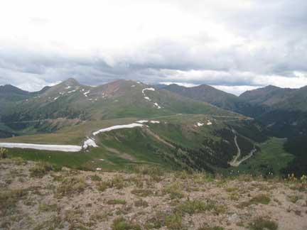
And looking south, would have been nice to keep going --

Had hoped to do a little afternoon rogaine practice in Leadville at a place that claims to be the highest course in North America (just under 10,000'), just to see how far the ball would go, but the rains moved in in a serious way.
The route.
One nice AOWN sighting, a flock of about 8 ptarmigans....
And the country was very pleasant, not much vegetation, lots of places you could go. Looking back north to the pass from as far south as I got --
And looking south, would have been nice to keep going --
Had hoped to do a little afternoon rogaine practice in Leadville at a place that claims to be the highest course in North America (just under 10,000'), just to see how far the ball would go, but the rains moved in in a serious way.
Tuesday Aug 5, 2008 #
run/hike 1:22:21 [3] 6.85 mi (12:01 / mi)
From Monarch Pass again, this time to the north. Actually, the plan was to start at the base of the ski area, hike up the northernmost lift line, and the go north on the open ridge for a while. But Gail was looking for a nice spot to paint, and the ski area was, well, on the ugly side. But she found a good spot up at the pass, so I went from there.
Much more running today as most of the route was rather gentle, the first third on a nice single-track, the rest on jeep roads around the top of the ski area. All was part of the Continental Divide Trail. 43:47 out, probably walked 10 minutes or so, 38:34 back, just walked 2 or 3 minutes. The pace was slow, but that doesn't mean that there wasn't lots of deep breathing, as the altitude was all about 11,500'. So overall good to be able to do some running, though the hard work made the actual doing a little less pleasant. At least I got back before the increasingly dark clouds developed into anything more threatening.
The Route.
The view to the north from the top of the middle chair lift showing where I had hoped to get to -- the round guy with snow on the SE side, not quite 13,000, but that was with starting a lot closer to it. As it was, I was 35 minutes to this spot, just time for one more down and up.

The view back to the south from the north end. The pass is visible in the distance.
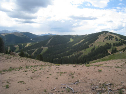
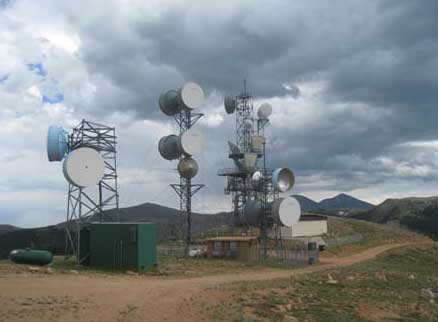
Pretty country. The towers were visited on Sunday's hike.

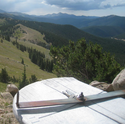
And finally, at one point I spotted a small contraption that looked like it might have a map on it, or something else interesting, and indeed it did -- a pair of keys.
Readers of this log with good memories will recall that I had an instance a while back of leaving car keys that were not there when I returned, thanks to some well-intentioned senior citizen who spotted them and turned them in to the authorities when he should have just left them alone.
So did I grab this pair and turn them in to the folks down at the pass? No way, I sure the guy is coming back for them.
Much more running today as most of the route was rather gentle, the first third on a nice single-track, the rest on jeep roads around the top of the ski area. All was part of the Continental Divide Trail. 43:47 out, probably walked 10 minutes or so, 38:34 back, just walked 2 or 3 minutes. The pace was slow, but that doesn't mean that there wasn't lots of deep breathing, as the altitude was all about 11,500'. So overall good to be able to do some running, though the hard work made the actual doing a little less pleasant. At least I got back before the increasingly dark clouds developed into anything more threatening.
The Route.
The view to the north from the top of the middle chair lift showing where I had hoped to get to -- the round guy with snow on the SE side, not quite 13,000, but that was with starting a lot closer to it. As it was, I was 35 minutes to this spot, just time for one more down and up.
The view back to the south from the north end. The pass is visible in the distance.
Pretty country. The towers were visited on Sunday's hike.
And finally, at one point I spotted a small contraption that looked like it might have a map on it, or something else interesting, and indeed it did -- a pair of keys.
Readers of this log with good memories will recall that I had an instance a while back of leaving car keys that were not there when I returned, thanks to some well-intentioned senior citizen who spotted them and turned them in to the authorities when he should have just left them alone.
So did I grab this pair and turn them in to the folks down at the pass? No way, I sure the guy is coming back for them.
Monday Aug 4, 2008 #
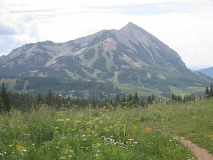
run/hike 1:16:37 [2] 5.95 mi (12:53 / mi) +1549ft 10:20 / mi
In Crested Butte, another hike up, jog down, this time to the top of Snodgrass Mountain and back, 2.97 miles one way, 1,550' climb, 50:22 up, 26:15 down. Jeep road all the way, not particularly scenic, not particularly interesting, but I had a very nice time. In fact I was thinking while I was climbing, and working reasonably hard but not too hard, that this was more fun than orienteering, because there was none of the physical suffering of orienteering. Hmm, can I skip out on Laramie? What I'd really like to do is go hike up Mt. Elbert, another nothing special hike, only done because it gets you to the supposedly highest point in Colorado. I hiked up Elbert when I was 13, and for some reason coming back down the same way was too boring, so we ran down the endless scree slope on the NE side of the mountain. That part I would not do it again.
But I doubt I will do it, because Stan has me scheduled to do his test climb on Thursday which we are supposed to do in under an hour, I think it climbs about 2,500 feet topping out at 11,500 (same distance as today's hike, just steeper), should not be any problem except the legs aren't there any more. Not that they ever were real good, I think I once did a little over 1,000 meters in an hour in Switzerland, but that's still pretty meager. But if I was to do Elbert on Wednesday, than I might pass totally on Stan's plan, and he would not appreciate that. Oh, well. Actually, I am looking forward to his course.
Today's route.
Top of Snodgrass (can you imagine going through life with that name?) was totally treed, one slight view to the NE....

But halfway down things opened up, nice views of the ski area and lots of flowers in the meadows.
But I doubt I will do it, because Stan has me scheduled to do his test climb on Thursday which we are supposed to do in under an hour, I think it climbs about 2,500 feet topping out at 11,500 (same distance as today's hike, just steeper), should not be any problem except the legs aren't there any more. Not that they ever were real good, I think I once did a little over 1,000 meters in an hour in Switzerland, but that's still pretty meager. But if I was to do Elbert on Wednesday, than I might pass totally on Stan's plan, and he would not appreciate that. Oh, well. Actually, I am looking forward to his course.
Today's route.
Top of Snodgrass (can you imagine going through life with that name?) was totally treed, one slight view to the NE....
But halfway down things opened up, nice views of the ski area and lots of flowers in the meadows.
Sunday Aug 3, 2008 #
run/hike 36:55 [2] 2.8 mi (13:11 / mi)
Nice (and short) trip up from Monarch Pass, 1.4 mi each way, hike up (23:09), jogged down easily (13:46), stopping to take a few pictures. Nice day, got done just before the thunderstorms rolled in. Altitude 11K+, didn't feel too bad, though I wasn't exactly pushing it.
Route.
Route.
Note
A few photos from the last couple of days....
My nephew Daniel, who we visited in Denver. He just finished taking the bar exam. Assuming he passed, he'll start working for the Public Defender Office in Golden. A fine and smart young man.

Stopped in Canon City for some rogaine practice. Interesting course, lots of slopes, excellent rogaine practice as I was searching in the bushes much more often than I cared.

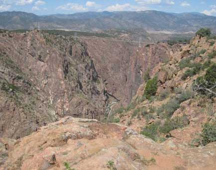
Next stop was Royal Gorge, pretty neat canyon, though we passed on the tourist trap at the suspension bridge (which I wouldn't have walked out on anyway).
Meanwhile, Gail was trying out her new brace (on the right knee), mixed reviews so far.

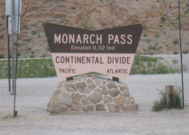
Last stop was at Monarch Pass, where if you pee at the sign (misplaced by about 100 yards) it all goes in the Pacific.
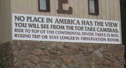
And the ad for the gondola lift was technically accurate....
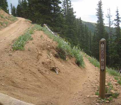
I hiked up, passed the fork to the right for the Continental Divide Trail, where the sign says no 4-wheeled vehicles (duh)....
And made it up to the top, where I assume I got radiated pretty thoroughly.
My nephew Daniel, who we visited in Denver. He just finished taking the bar exam. Assuming he passed, he'll start working for the Public Defender Office in Golden. A fine and smart young man.
Stopped in Canon City for some rogaine practice. Interesting course, lots of slopes, excellent rogaine practice as I was searching in the bushes much more often than I cared.
Next stop was Royal Gorge, pretty neat canyon, though we passed on the tourist trap at the suspension bridge (which I wouldn't have walked out on anyway).
Meanwhile, Gail was trying out her new brace (on the right knee), mixed reviews so far.
Last stop was at Monarch Pass, where if you pee at the sign (misplaced by about 100 yards) it all goes in the Pacific.
And the ad for the gondola lift was technically accurate....
I hiked up, passed the fork to the right for the Continental Divide Trail, where the sign says no 4-wheeled vehicles (duh)....
And made it up to the top, where I assume I got radiated pretty thoroughly.
C • sign 6