Training Log Archive: JayXCIn the 31 days ending Jul 31, 2015:
| ||||||||||||||||||||||||||||||||||||||||||||||||||||||||||||||||||||||||||||||||||||||||||||||||||||||||||||||||||||||||||||||||||||||||||||||||
| « | » |
| » now | |||||||||||||||||||||||||||||||||||||||||||||||||||||||||
| We | Th | Fr | Sa | Su | Mo | Tu | We | Th | Fr | Sa | Su | Mo | Tu | We | Th | Fr | Sa | Su | Mo | Tu | We | Th | Fr | Sa | Su | Mo | Tu | We | Th | Fr | ||||||||||||||||||||||||||||||
Friday Jul 31, 2015 #
Run 46:45 [3] 6.0 mi (7:48 / mi) +395ft 7:20 / mi
slept:6.0 shoes: Hoka Mafate 3
Thursday Jul 30, 2015 #
Mtn Bike 1:47:49 17.09 mi (9.5 mph) +926ft
ahr:102 max:152
Wednesday Jul 29, 2015 #
Run 47:34 [3] 6.0 mi (7:56 / mi) +395ft 7:28 / mi
slept:7.5 shoes: Hoka Mafate 3
Tuesday Jul 28, 2015 #
Road Bike 1:21:09 20.68 mi (15.3 mph) +694ft
ahr:100 max:144
Monday Jul 27, 2015 #
Note
slept:7.5 (rest day)
Sunday Jul 26, 2015 #
Run 41:06 [3] 5.53 mi (7:26 / mi)
slept:8.0 shoes: Hoka Mafate 3
Road Bike 2:35:39 38.56 mi (14.9 mph) +1969ft
ahr:127 max:172
Saturday Jul 25, 2015 #
Road Bike 2:22:00 [3] 39.4 mi (16.6 mph)
slept:8.0
Road Bike 2:41:22 39.34 mi (14.6 mph) +1552ft
ahr:120 max:163
Friday Jul 24, 2015 #
Note
slept:8.0 (rest day)
Thursday Jul 23, 2015 #
Note
slept:8.0 (rest day)
Wednesday Jul 22, 2015 #
Note
slept:8.0 (rest day)
Tuesday Jul 21, 2015 #
Note
slept:7.5 (rest day)
Monday Jul 20, 2015 #
Note
slept:7.0 (rest day)
Sunday Jul 19, 2015 #
Orienteering 2:30:00 [3] 6.0 km (25:00 / km)
slept:2.0
I found it pretty difficult to jump onto the o-course immediately after our nap. Finally I just took a bearing to the first CP and fortunately we walked right to it. Once there things started to click and we hit 2 more CPs before running out of time and heading back to the TA.
Mtn Bike 5:34:00 [3] 113.0 km (20.3 kph)
Run 32:00 [3] 5.0 km (6:24 / km)
shoes: Salomon XT Wings (grey/green)
Raft paddle 39:00 [3] 5.0 km (7:48 / km)
Saturday Jul 18, 2015 #
Mtn Bike 6:20:00 [3] 75.0 km (11.8 kph)
slept:0.33
Orienteering 2:40:00 [3] 5.0 mi (32:00 / mi)
Mtn Bike 15:00:00 [3] 56.0 km (3.7 kph)
The Yogaslackers passed us early on while climbing to the first pass in between rain showers. Once on the backside we just followed along behind them. By the next pass I had lost our position on the map and thought we were one pass ahead. With a little back-tracking and a comment by NYARA as they passed I was able to re-locate and we rode on to the canyon CP with a slight rest for a flat tire repair along the way.
At the campground we discovered we needed to hike to the river below for one CP then once we returned we’d be rewarded with hamburgers from Denise Mast and NYARA, excellent!
Next stop would be EOD3 but not before we had to navigate through the mess of roads south of CP41. Roads which should have been on one side of a significant feature were on the other side, new roads appeared, some roads didn’t exist, etc. Fortunately I made it through without much issue aside from not finding the well CP despite attacking from 2 different directions.
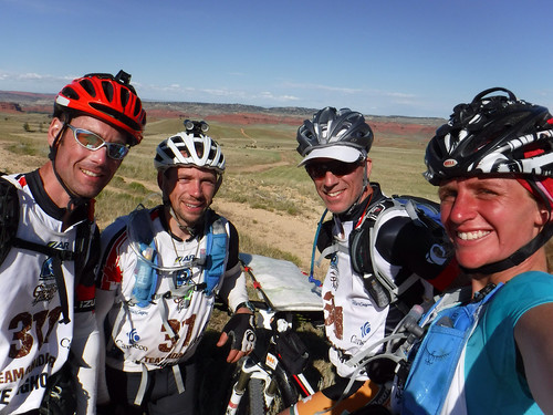
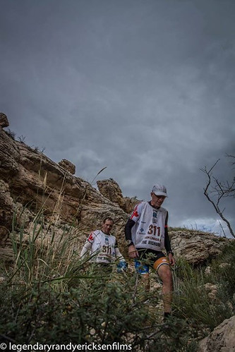
Friday Jul 17, 2015 #
Trek 10:28:00 [3] 18.0 km (34:53 / km)
slept:0.0 shoes: Salomon XT Wings (grey/green)
Fortunately Hunter’s team came by and we were able to locate our position and then not too long after the trail down. It was a relatively easy trail hike to the EOD1 but we had missed the time cut and would become unranked.
Mtn Bike 12:00:00 [3] 68.0 km (5.7 kph)
Thursday Jul 16, 2015 #
Run 20:00 [3] 4.0 km (5:00 / km)
slept:5.0 shoes: Salomon XT Wings (grey/green)
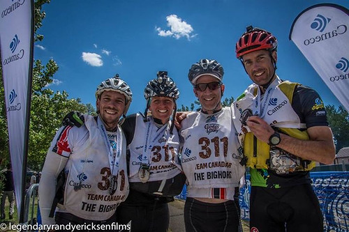
We departed at 6am from Casper in buses and arrived at Crazy Woman Square in Buffalo around 8am where we were given our trackers and the local Buffalo map. I transposed the 4 CPs from the race maps onto the local map and noticed that pre-plotted locations for the Sporting Lure and the Occidental Saloon were wrong.
At 9am the Governor started us with a loud bang that did not come from the pistol he was holding and we were off. We hit the Sporting Lure on our way to the pool and I noticed that the Swedish Army team had missed it and were running south to its location on the race map. At the pool Fritz ignored the line of teams on the diving board and jumping from the edge and made quick work of punching the control at the bottom of the pool. We next ran out to the Steakhouse for our telegram and then hit the Saloon for our shot of whiskey just prior to getting on the bikes.
Mtn Bike 1:02:00 [3] 23.0 km (22.3 kph)
canoe paddle 1:33:00 [3] 16.0 km (10.3 kph)
As we approached the southwest corner a number teams in front of us turned back north but continued hunting for the point along the shore. We joined the search and stuck around longer than we should have before giving up in it. Looking at the GPS tracker paths it’s clear that the points were actually where we had plotted them but the lake/reservoir has undergone a severe change in shape at some point since the map was made. I expect the 2 teams that did find CP12 found it to the west of the actual corner of the lake. After that it was an uneventful paddle to the take out.
Mtn Bike 44:00 [3] 21.0 km (28.6 kph)
Trek 8:56:00 [3] 34.0 km (15:46 / km)
shoes: Salomon XT Wings (grey/green)
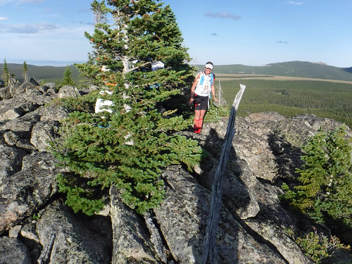
It was a long climb up to CP19 heading south when we ran into the Wilderness Boundary slightly before I expected it. In addition, there was a trail heading to the west which was not shown on the map. Prior to hitting the Boundary we should have seen a trail heading east towards Gem Lake but nothing was obvious. We walked along the eastern edge of a wide opening nearby and I found a subtle trail heading east which we started following. Within a few 100m it seemed to stop. We also spotted a number of small ponds which made me think we were quite a bit to the north of where we wanted to be. We took a south bearing from there and came across a wet open area that I thought could be the edge of the lake we were looking for. We followed it south and unfortunately it turned out to be the edge of a swamp to the south of our trail. We ended up taking it too far to the south (unknowingly) and hit a parallel trail heading to the east which made me think we were heading towards the lake. It wasn’t until the trail made a strange turn that I finally realized we were about 1.5k away from where we wanted to be. Compounding our problem we could not find the shortcut trail to the E-W trail we were looking for so we ended up doing a very large loop to get back to where we were about 3 hours prior. Now sure of our position I was able to take a bearing to the south end of Gem Lake pretty quickly and we found 6-8 teams huddled around a campfire near CP19. Apparently the trail everyone expected leaving the CP could not be found.
Wednesday Jul 15, 2015 #
Note
slept:7.0 (rest day)
Tuesday Jul 14, 2015 #
Note
slept:7.0 (rest day)
Food shopping in the evening.
Monday Jul 13, 2015 #
Note
slept:7.5 (rest day)
Sunday Jul 12, 2015 #
Road Bike 1:42:05 29.79 mi (17.5 mph) +1060ft
ahr:117 max:164 slept:8.0
Saturday Jul 11, 2015 #
Run 59:43 8.25 mi (7:14 / mi) +390ft 6:56 / mi
ahr:159 max:220 slept:7.75
Road Bike 1:23:27 23.64 mi (17.0 mph) +1397ft
ahr:137 max:167
Thursday Jul 9, 2015 #
Run 45:01 [3] 5.1 mi (8:50 / mi)
slept:7.0 shoes: Hoka Mafate 3
Road Bike 46:00 [2] 12.0 mi (15.7 mph)
Wednesday Jul 8, 2015 #
Note
slept:7.5
Tuesday Jul 7, 2015 #
Run 46:34 [3] 6.0 mi (7:46 / mi) +395ft 7:18 / mi
slept:8.0
Monday Jul 6, 2015 #
Road Bike 38:00 [3] 10.0 mi (15.8 mph)
slept:8.0
Sunday Jul 5, 2015 #
Kayak (V10) 2:04:00 [3] 12.0 mi (5.8 mph)
slept:9.0
Saturday Jul 4, 2015 #
Road Bike 1:12:57 20.63 mi (17.0 mph) +728ft
ahr:108 max:149 slept:9.0
Friday Jul 3, 2015 #
Trek 13:16:36 [3] 23.32 mi (34:10 / mi) +8630ft 25:18 / mi
slept:5.0 shoes: Hoka Mafate 3
Trek 1 [3] 0.0 mi
slept:0.0
Wednesday Jul 1, 2015 #
Run 46:35 [3] 6.0 mi (7:46 / mi) +395ft 7:18 / mi
slept:7.75