Training Log Archive: vmeyerIn the 1 days ending Jan 15, 2013:
| ||||||||||||||||||||||||||||||||||||||||
| « | » |
| » now | ||||
| Tu |
Tuesday Jan 15, 2013 #
Event: Sprint the Bay 2013
11 AM
Orienteering race 36:20 [3] *** 2.24 mi (16:13 / mi) +61m 14:57 / mi
shoes: Another pair of new shoes!!
Sprint the Bay - six events in three days.
From the STB website - Description: the first stage will be held on an updated Woodford map. This map is part of the Woodford Iona map first used for the NZ champs in 2011. It consists of very technical building detail, school grounds and farm type terrain. Parts of the map are very steep making it very physically demanding and also allowing for difficult route choice legs.
Setup was easier with the reduced number of monitors, and it was nice to have the start and finish within meters of each other. However, the reduction of the monitors to two proved to be somewhat inadequate for the number of results needing to be display.

 (Courtesy of P. Herries.)
 (Courtesy of P. Herries.)

A little sloppy to 1, then made back 10 spots in the buildings, and was in 14th place through 10. Then I was unsure about climbing the fence into 11, in terms of legality and safety. Probably still wouldn't have climbed, even if I had seen the crossable part indicated on the map, so I ran around to the gate.
Then, I lost my mind going to 12, visiting 7 and 8 again before sorting myself out. Agh!! But, at least I didn't mispunch.

Race stats: 2.0 km, 75m climb, 16 controls
Garmin distance: 2.24 miles with 61 m climb
Place: 21/24
Time: 36:19
Time lost:
Time per km: 18:25
Finish split: 10th – 16 seconds, with 1st at 13 seconds.
From the STB website - Description: the first stage will be held on an updated Woodford map. This map is part of the Woodford Iona map first used for the NZ champs in 2011. It consists of very technical building detail, school grounds and farm type terrain. Parts of the map are very steep making it very physically demanding and also allowing for difficult route choice legs.
Setup was easier with the reduced number of monitors, and it was nice to have the start and finish within meters of each other. However, the reduction of the monitors to two proved to be somewhat inadequate for the number of results needing to be display.
(Courtesy of P. Herries.)
(Courtesy of P. Herries.)
A little sloppy to 1, then made back 10 spots in the buildings, and was in 14th place through 10. Then I was unsure about climbing the fence into 11, in terms of legality and safety. Probably still wouldn't have climbed, even if I had seen the crossable part indicated on the map, so I ran around to the gate.
Then, I lost my mind going to 12, visiting 7 and 8 again before sorting myself out. Agh!! But, at least I didn't mispunch.
Race stats: 2.0 km, 75m climb, 16 controls
Garmin distance: 2.24 miles with 61 m climb
Place: 21/24
Time: 36:19
Time lost:
Time per km: 18:25
Finish split: 10th – 16 seconds, with 1st at 13 seconds.
7 PM
Orienteering race 33:01 [3] *** 2.3 mi (14:21 / mi) +1m 14:20 / mi
shoes: Black Brooks
In between the morning and evening races, Phillip and Tim added a small extension to the monitor stand in order to add another two monitors in the vertical position. These gave enough room to get some splits up for everyone.
Sadly, I have no pictures from this day, probably because this was a fast and furious setup since we couldn't get into the park until after closing time. We also had to carry all of the equipment about 100 feet from the trailer to the event center. Even with lots of hands, things ran behind, and the starts were delayed 30 minutes.
Description: A brand new map in New Zealand's biggest water park. This will be a highlight of STB 2013 for both competitors and spectators. Terrain consists of intricate park detail, and building areas, you will face very fast but technical courses and expect to get wet!
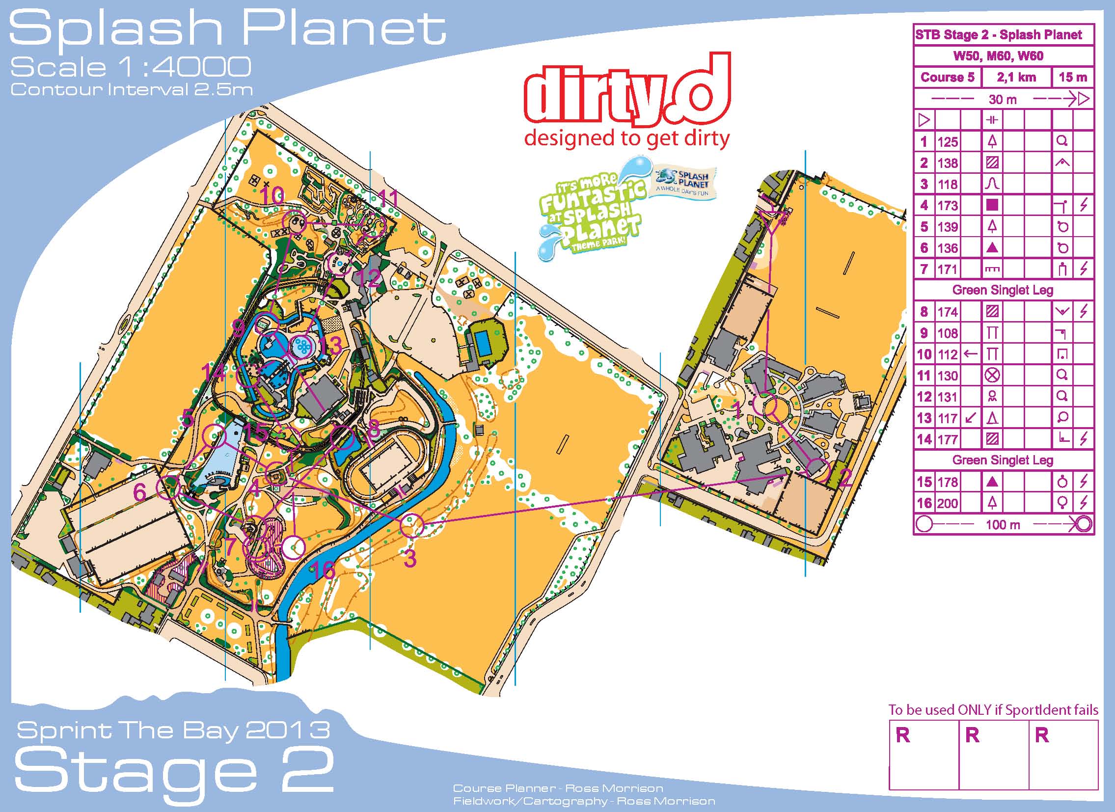
Started later than even my delayed start, so I was the nearly the last starter with just a few elites behind me. From 3-4, I cut across the water, which was possibly illegal. I had interpreted the rules to be that you couldn't cross the dark blue water inside the park. From the wet footprints, and the split times to this control, I wasn't the only one who went this way.
So confused at times, especially from 10-12. Took full advantage of the romp through the water at 13
This was a fun course, which may have more fun if I hadn't been out there by myself in the setting sun, as the elites were cooling down and/or rerunning part of the course. But, I didn't mispunch, so it was a good day.
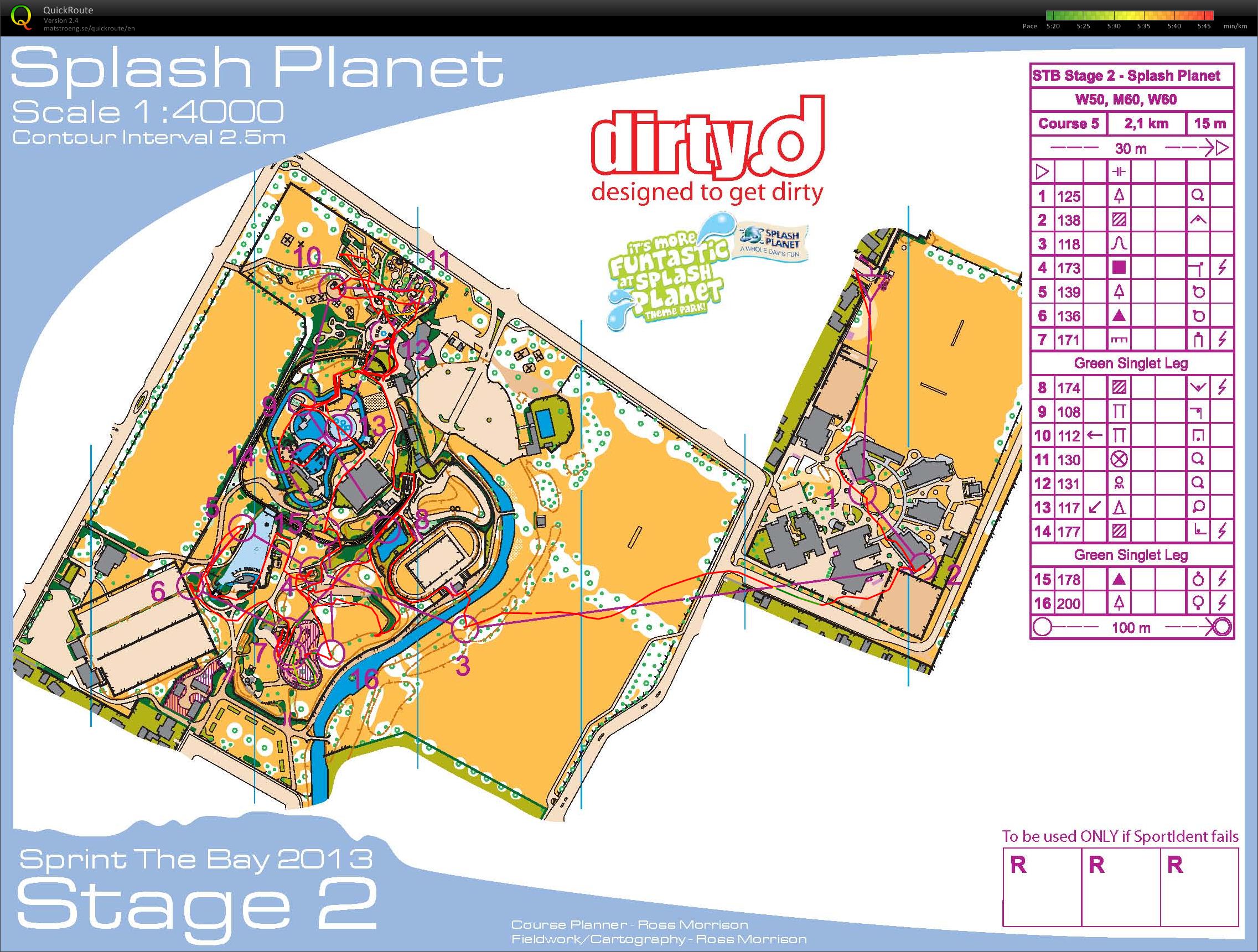
Race stats: 2.1 km, 15m climb, 16 controls
Garmin distance: 2.3 miles with 1 m climb
Place: 20/24
Time: 33:00
Time lost:
Time per km: 15:43
Finish split: 9th – 29 seconds, with 1st at 26 seconds.
Sadly, I have no pictures from this day, probably because this was a fast and furious setup since we couldn't get into the park until after closing time. We also had to carry all of the equipment about 100 feet from the trailer to the event center. Even with lots of hands, things ran behind, and the starts were delayed 30 minutes.
Description: A brand new map in New Zealand's biggest water park. This will be a highlight of STB 2013 for both competitors and spectators. Terrain consists of intricate park detail, and building areas, you will face very fast but technical courses and expect to get wet!
Started later than even my delayed start, so I was the nearly the last starter with just a few elites behind me. From 3-4, I cut across the water, which was possibly illegal. I had interpreted the rules to be that you couldn't cross the dark blue water inside the park. From the wet footprints, and the split times to this control, I wasn't the only one who went this way.
So confused at times, especially from 10-12. Took full advantage of the romp through the water at 13
This was a fun course, which may have more fun if I hadn't been out there by myself in the setting sun, as the elites were cooling down and/or rerunning part of the course. But, I didn't mispunch, so it was a good day.
Race stats: 2.1 km, 15m climb, 16 controls
Garmin distance: 2.3 miles with 1 m climb
Place: 20/24
Time: 33:00
Time lost:
Time per km: 15:43
Finish split: 9th – 29 seconds, with 1st at 26 seconds.