Training Log Archive: AnvilIn the 7 days ending Aug 8, 2009:
| ||||||||||||||||||||||||||||||||||||||||
| « | » |
| » now | ||||||||||
| Su | Mo | Tu | We | Th | Fr | Sa | |||||||
Saturday Aug 8, 2009 #
Orienteering race 58:31 [3] 3.3 km (17:44 / km) +230m 13:09 / km
shoes: Triumphs v2.0
Swiss O Week, Day 6.
Bit of a disappointing end to the week. The area we were meant to run on had been cut off by landslides from the rain earlier in the week and was deemed not safe to run on as rain was forecast later in the day (which did happen, almost on cue at 2pm). So ad-hoc courses were put together on the day 5 map using controls from the event (full credit to the organisers for pulling it together in about 12 hours!).
But, my heart wasn't in it - never worked at it and let the terrain push me round, went well off line many times. Clouds descended half way through and it was so dark under the canopy it was really hard to read the map. Surprised I ended up 30th, but I think a lot of the Swiss just went home and didn't bother.
Then to make it worse we saw the map we would have run on - similar terrain to day 4 (my favourite), with a massive 280m climb in the 2nd leg!
Still, loved the week and the terrain, especially the high mountain stages. Now thinking about Flims in 2011, which is meant to be the best in Swissland....
Friday Aug 7, 2009 #
Orienteering race 53:38 [5] 3.3 km (16:15 / km) +220m 12:11 / km
shoes: Triumphs v2.0
Swiss O Week, Day 5
Can't say I enjoyed that much. Billed as 'The Rough Day', it was a thickly forested limestone plateau. Not insane limestone detail, but so rough that it was impossible to get any rhythm going for longer than 30m or so. I like the running part of this sport these days, so it wasn't really my thing.
One corker of a mistake, a leg where you just had to go up a spur to a knoll and into a depression on the side. I didn't notice another knoll that was half way up the spur and proceeded to search below that one, which conveniently had enough detail where I expected the control to confuse me for 5 minutes or so. Nothing else apart from that, except for being a pussy on the long route choice leg and not pushing hard enough in the terrain.
Thursday Aug 6, 2009 #
Orienteering race 1:22:39 [5] 9.7 km (8:31 / km) +260m 7:31 / km
shoes: Inov8 Roclites v2.0
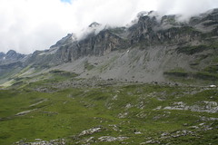
Swiss O Week, Day 4.
Awesome area, frustrating run.
We were driven up to 2000m and the course descended 800m throgh a valley surrounded by epic mountains to the finish - after a little loop at the top to get the climb in. Was totally open, super fast runnable grass with lots of glaciated detail, depressions and little gullies all over the place.
Was having the best run of this trip, spiking like a mad man, bar a minute on #10 from following some tracking that wasn't mine through a marsh and going offline. After 20 we dropped out of the detail, 21 was on an obvious vegetation boundary just off a road - I look ahead to 22, a tricky diagonal downhill leg through the first forest of the course. Spot the line of trees that 21 should be on, drop off the road and follow them along to the corner.... no control. Hmmm. Look around, no tracking - I was the 3rd last starter and had gotten used to the tracks out of the controls. Look around, on a line of trees, on the edge of yellow, just like the map. Hmmm. Where am I? Climb 25m back up to the road, there's the bend where it should be. I know where I am, where is the control? 9 minutes later I'm directed to it by the last starter on the course, on a lone tree. People seemed to think the map was dodgy there, but spotted the control easily - I guess I was looking at the map for the next leg when I should have been looking at the forest.
Anyway, finish off the course a little grumpy. Was 6th overall until the mistake, finished 17th.
Tuesday Aug 4, 2009 #
Orienteering race 1:22:13 [4] 7.4 km (11:07 / km) +260m 9:27 / km
shoes: Inov8 Roclites v2.0
Swiss O Week, Day 3.
The day that involved an 800m climb walk to the start.
Pretty cool area, not quite as exciting as the organisers let on though. Pushed pretty hard in the open alpine meadow legs, controls were visible from 3-400m away a lot of the time. Spiked the first 2 controls in the limestone, got cocky/lazy/overconfident and made 12 minutes of mistakes on the next 3. Good for the rest.
Went back out in the terrain and took some good photos. Pretty specky stuff.
Spot Ilka!
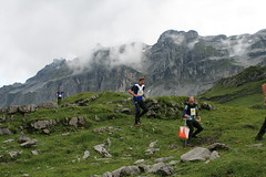
Hows the serenity
The day that involved an 800m climb walk to the start.
Pretty cool area, not quite as exciting as the organisers let on though. Pushed pretty hard in the open alpine meadow legs, controls were visible from 3-400m away a lot of the time. Spiked the first 2 controls in the limestone, got cocky/lazy/overconfident and made 12 minutes of mistakes on the next 3. Good for the rest.
Went back out in the terrain and took some good photos. Pretty specky stuff.
Spot Ilka!
Hows the serenity
Monday Aug 3, 2009 #
Orienteering race 1:28:29 [4] 8.0 km (11:04 / km) +270m 9:28 / km
Swiss O Week, Day 2.
Steep area and cause of the rain the day before, very muddy area.
Started raining again just as I started, little error on the 1st cause I spent too long folding the map and ran further along the start track that I thought. All OK except for a poor route choice to 4 trying to follow a track through a very rough limestone pavement.
Went slow on the limestone section later cause it was almost impossible to run (and a little scary, big jagged rock chunks and big drops between the chunks) but still went off line and ended up stuck half way down a cliff. Had trouble interpreting how they map the limestone here.
Utilised the arse sliding method on the downhill drop to the finish, all courses descended the hill at the same point (the only part of the map where it was safe to), which had become a slope of mud by the time I'd started.
Fun day, would have liked to be a little higher in the results, but OK for my first proper attempt at Swiss terrain.
C • No 4 2
Sunday Aug 2, 2009 #
Event: Swiss O Week!
Orienteering race 20:27 [5] 2.6 km (7:52 / km) +90m 6:42 / km
shoes: Triumphs v2.0
Swiss O Week, Day 1.
Sprint in Schwyz centre. Tricky area, heaps of out of bounds and impassable walls. 2 mins 20 secs total mistakes, worst being 70 seconds when I ended up in an out of bounds area (someones backyard), though there was no clear distinction of the boundary.
Felt slow for a sprint, either the previous days hiking or months of no speedwork hasn't been good to me. Good fun but, even if it was in a thunderstorm!