Training Log Archive: sherpesIn the 31 days ending Oct 31, 2018:
| ||||||||||||||||||||||||||||||||||||||||
| « | » |
| » now | ||||||||||||||||||||||||||||||||||
| Mo | Tu | We | Th | Fr | Sa | Su | Mo | Tu | We | Th | Fr | Sa | Su | Mo | Tu | We | Th | Fr | Sa | Su | Mo | Tu | We | Th | Fr | Sa | Su | Mo | Tu | We | |||||||
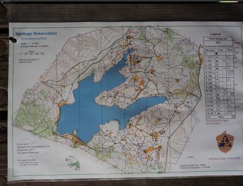
Sunday Oct 14, 2018 #
Event: WPOC Heritage Orienteering
Orienteering race 1:21:26 [3] 7.5 km (10:51 / km)
shoes: Inov-8 330 Mudclaw
New place near the Pennsylvania - West Virginia border. I was expecting rhododendron, rock formations, groves of hemlock trees, but it was a rather bland forested area.
Messed up the leg from 8 to 9. I was on the road and mentally chose to detach myself from the road when the road crossed a creek. Problem was, I chose the wrong creek. Should have stayed on the road a bit longer.
Leg 1: easy run from the small parking lot
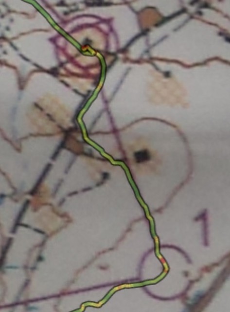
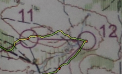
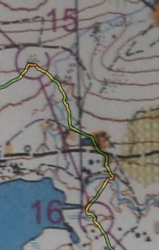
Leg 2: found the ride along the hilltop, kept an eye to the open clearing on the hilltop, and funny thing, stopped, thinking "it should be right there" and I wasn't seeing it, when it was 5 meters from me. My eyes are getting old... Can you see the tiny red dot inside the circle when I stopped 5 meters from the control ?
Leg 3: nothing remarkable to report
Leg 4: don't remember much about this leg
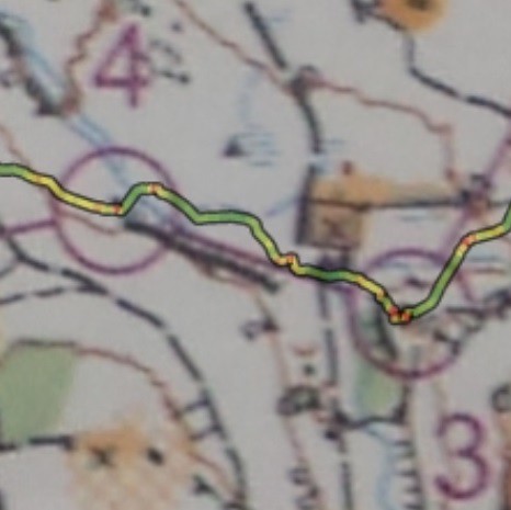
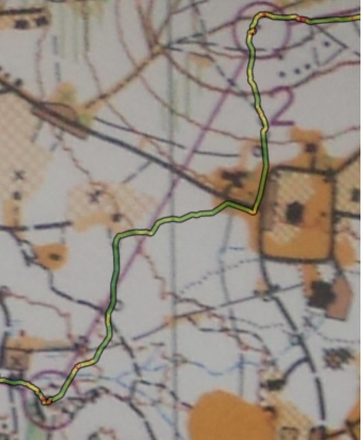
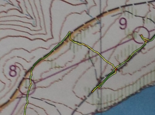
Leg 5: looks like my route was all green except for the final approach. Saw some knolls and thought that the control was behind one of them. (red dots on my route). I was wrong. The control was further down, tucked in a veggie corner
Leg 6: no difficulty here
Leg 7: in the final approach, stayed on the high ground, and when I spotted the control, ran downhill to it.
Leg 8: somehow, messed up this one. After crossing the first jeep road, was going uphill, when I encountered a forest road. I was confused, as I didn't expect it (on the map, it was marked as a ride). Continuing uphill, I encountered a second forest road. That road had a little hilltop on the north of the road. Looking at the area around control 8, I notice that it has a road, and a little hilltop on the NorthWest. Was I in that spot? so, went looking for the control, and of course it wasn't there. So I stop and carefully study the map, and then realize that there was a somewhat parallel situation up north. And so I went and found it no problema. Talking to Jim Trautmann, he said he experienced the identical perception.
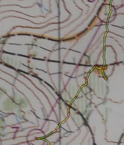
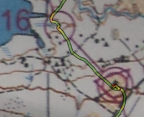
Leg 9: screwed up on this one. After 8, went on the large gravel road and ran. Made a mental note to myself to detach from the road when the road goes over a creek. Problem was: I chose the wrong creek. Should have stayed on the road until the second creek was encountered. Once uphill on the forest road, got fearful that I overshot the control and went back a bit, until I saw the trail going to the lake. So, to find the control I started identifying each knoll on the side of the forest road. The control was in a depression and not visible from the road.
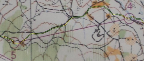
Leg 10: no issues here. Saw the faint trail in the reentrant, and used that as attackpoint to veer off the forest road.
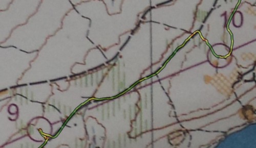
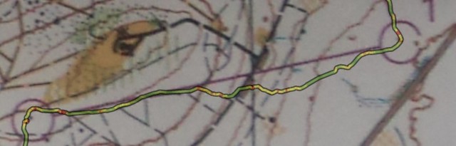
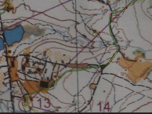
Leg 11: no issues here. Long run. The red dot is where I stopped to remove my long sleeve shirt. It stopped raining, the air got warmer, and I got warmer.
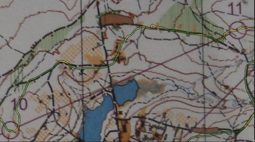
Leg 12: stayed high and followed down the spur
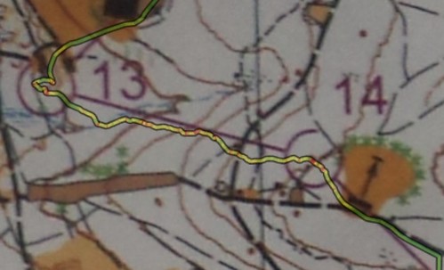
Leg 13: run on forest and gravel roads, grassy downsloped lawns, and zero in-ing into a chute between two small building structures, only to find myself at full stop, wondering where the control was. Upon closer look, noticed it was right on the south of the westernmost building, and that is where I went looking. Tucked below in a depression. Clever.
Leg 14: crossed the creek and somewhat went up a spur
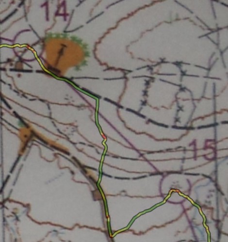
Leg 15: Somehow screwed up on this one too. Went downhill traversing a a bit, and said to myself "as soon as you hit trail, take it", that is, the trail marked going from West to East. The control is right next to the trail. Never saw the trail. Hit the road, thinking to use the curve of the road as point to leave the road and enter the woods, but apparently I was much more downhill than I wanted to. Made the mistake of not "reading" the terrain slopeness, as it went from steep to not-so-steep. Should have stayed at that altitude, instead of descending even more. And once on the gravel road, missed the small parking area (marked as gravel, but in reality it was grassy - i know because that is where i parked my vehicle during control pickup). Once I realized where I was, as I could visibly see the bottom of the road, I then went on a straight walk on somewhat uphill woodsy terrain and zeroed-in on to the control.
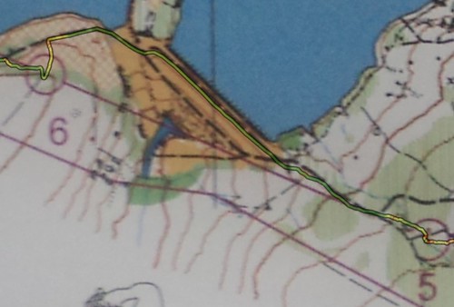
Leg 16: trotting downhill, across a creek, jumping between logs and ferns, find myself on a retaining earth bank and a little miniature pond on one side, then a clearing and a gravel road, and the large creek that it was advised not to wade across in the meet notes. My eyes did not see the trail and presumed footbridge on the map, so I waded across the creek, and it was deep to below the knee on a stone bottom, no mud or silt or tree logs on visibly clear water. Safe crossing.
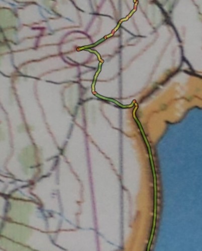
Leg 17: final leg. One could hear human voices of the finish. Went to that direction. Then visually could see the shelter.
Messed up the leg from 8 to 9. I was on the road and mentally chose to detach myself from the road when the road crossed a creek. Problem was, I chose the wrong creek. Should have stayed on the road a bit longer.
Leg 1: easy run from the small parking lot
Leg 2: found the ride along the hilltop, kept an eye to the open clearing on the hilltop, and funny thing, stopped, thinking "it should be right there" and I wasn't seeing it, when it was 5 meters from me. My eyes are getting old... Can you see the tiny red dot inside the circle when I stopped 5 meters from the control ?
Leg 3: nothing remarkable to report
Leg 4: don't remember much about this leg
Leg 5: looks like my route was all green except for the final approach. Saw some knolls and thought that the control was behind one of them. (red dots on my route). I was wrong. The control was further down, tucked in a veggie corner
Leg 6: no difficulty here
Leg 7: in the final approach, stayed on the high ground, and when I spotted the control, ran downhill to it.
Leg 8: somehow, messed up this one. After crossing the first jeep road, was going uphill, when I encountered a forest road. I was confused, as I didn't expect it (on the map, it was marked as a ride). Continuing uphill, I encountered a second forest road. That road had a little hilltop on the north of the road. Looking at the area around control 8, I notice that it has a road, and a little hilltop on the NorthWest. Was I in that spot? so, went looking for the control, and of course it wasn't there. So I stop and carefully study the map, and then realize that there was a somewhat parallel situation up north. And so I went and found it no problema. Talking to Jim Trautmann, he said he experienced the identical perception.
Leg 9: screwed up on this one. After 8, went on the large gravel road and ran. Made a mental note to myself to detach from the road when the road goes over a creek. Problem was: I chose the wrong creek. Should have stayed on the road until the second creek was encountered. Once uphill on the forest road, got fearful that I overshot the control and went back a bit, until I saw the trail going to the lake. So, to find the control I started identifying each knoll on the side of the forest road. The control was in a depression and not visible from the road.
Leg 10: no issues here. Saw the faint trail in the reentrant, and used that as attackpoint to veer off the forest road.
Leg 11: no issues here. Long run. The red dot is where I stopped to remove my long sleeve shirt. It stopped raining, the air got warmer, and I got warmer.
Leg 12: stayed high and followed down the spur
Leg 13: run on forest and gravel roads, grassy downsloped lawns, and zero in-ing into a chute between two small building structures, only to find myself at full stop, wondering where the control was. Upon closer look, noticed it was right on the south of the westernmost building, and that is where I went looking. Tucked below in a depression. Clever.
Leg 14: crossed the creek and somewhat went up a spur
Leg 15: Somehow screwed up on this one too. Went downhill traversing a a bit, and said to myself "as soon as you hit trail, take it", that is, the trail marked going from West to East. The control is right next to the trail. Never saw the trail. Hit the road, thinking to use the curve of the road as point to leave the road and enter the woods, but apparently I was much more downhill than I wanted to. Made the mistake of not "reading" the terrain slopeness, as it went from steep to not-so-steep. Should have stayed at that altitude, instead of descending even more. And once on the gravel road, missed the small parking area (marked as gravel, but in reality it was grassy - i know because that is where i parked my vehicle during control pickup). Once I realized where I was, as I could visibly see the bottom of the road, I then went on a straight walk on somewhat uphill woodsy terrain and zeroed-in on to the control.
Leg 16: trotting downhill, across a creek, jumping between logs and ferns, find myself on a retaining earth bank and a little miniature pond on one side, then a clearing and a gravel road, and the large creek that it was advised not to wade across in the meet notes. My eyes did not see the trail and presumed footbridge on the map, so I waded across the creek, and it was deep to below the knee on a stone bottom, no mud or silt or tree logs on visibly clear water. Safe crossing.
Leg 17: final leg. One could hear human voices of the finish. Went to that direction. Then visually could see the shelter.
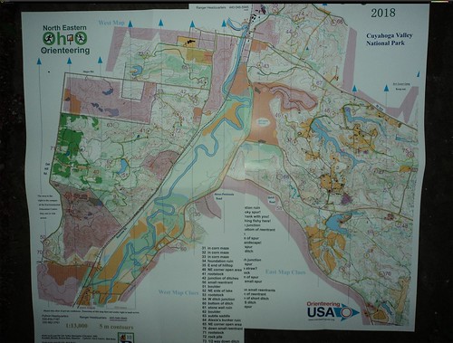
Saturday Oct 6, 2018 #
Event: WPOC Beaver Street-O
Event: Step Trek
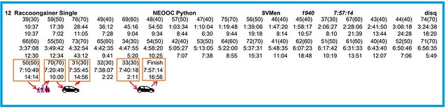
Orienteering race (rogaining) 7:59:59 [4]
At hour 7h20m, was at control 50 at the most distant location from finish. No way I could make it back. Called Rogainer Limo LLC and got picked up and automobile-driven to the finish in style. Next time, gonna do like James Bond 007, takes off his outdoors clothing to reveal an undergarment, a T-U-X-E-D-O (2:15), get into the limo and drink a dry martini shaken not stirred, and dropped to the finish.
Data:
34.60 km in 7h30m
hour 1: 4.7 km
hour 2: 5.3 km
hour 3: 4.2 km
hour 4: 4.0 km
hour 5: 4.5 km (sidewalks, roads, trails)
hour 6: 3.1 km (horrible thorns, and tree log jammed creeks)
hour 7: 5.1 km (lots of easy trails)
last half hour, at an hourly rate of 7.0 km/hr, mostly because of a long downhill paved road stretch
Route:
Was at Peninsula at half-time mark (4:00) and from past two years experience, it was ok to be there at that time and go counter-clockwise with a long run in the dark on the paved road from the corn maze back to Camp Manatoc. Not this time. Apparently I just lost an amazing amount of time finding controls in the western map, or maybe my body is not the same as in the past few years and maybe I should just revert to bird watching or recreational mushroom hunting. But I had alot of fun. Shout-out to Brenda from Michigan, that I just naturally paired with as we ended up going on the same route at the same pace for many many hours.
btw: want to make a 30-second TV commercial advertisement for a metaphorical company named "A1 Limo" or "Rogaining Limo", in which, an exhausted rogainer, finding himself at the most distant control from the finish, and with only 40 minutes of time left, calls in a limo and say "meet me at the Corn Maze in 20 minutes." At the corn maze lot, limo appears, rogainer removes the muddied and thorned-up shirt, to reveal an undergarment that is a tuxedo (2:15). Rogainer walks to the limo, the limo driver is holding the limo door open, and rogainer, before stepping in, says to the TV camera, "You wanna finish your rogaining in style. YOU deserve it", pointing the index finger and arm towards the camera.
THE MISTAKE: at around control 74, we traversed the slope looking for the ditch, and we never saw it or recognized it.
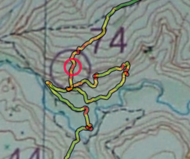
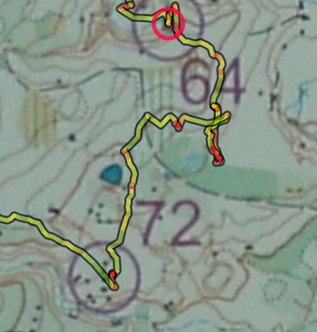
Going from 64 to 72 had some horrible thorny bushes, that made it impossible to continue unless you wanted to have bloody scratches on your arms and legs. Retreated.
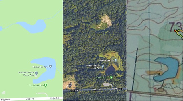
Near control 73, saw a big open land area that is not indicated as such on the map. Now that I can see it via Google Maps, it looks like it was a small lake now drained.
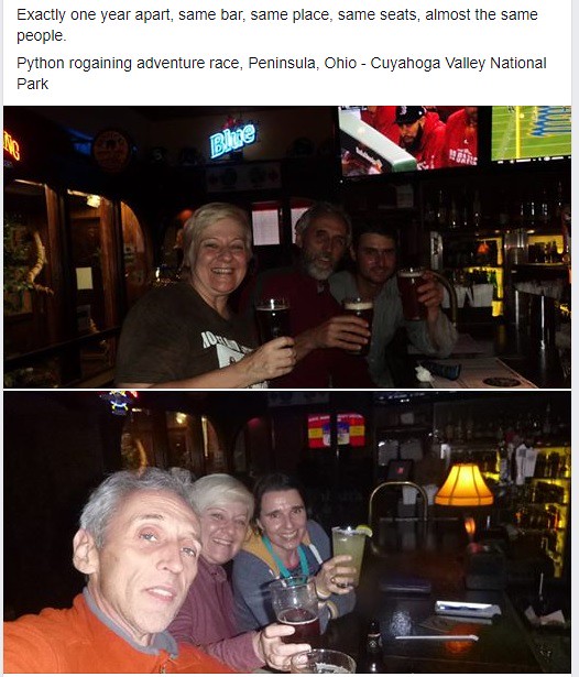
The tradition of going for a beer after the event at the Winking Lizard Tavern in Peninsula continues !!
I did finish with two minutes to spare, one way or another !! assist by course setter randomly encountered at control 50, and then his vehicle, a Toyota, to the corn maze, and then, another vehicle, a Subaru, from the corn maze to the finish on the long stretch of paved road. Next time, have a dry martini, shaken not stirred, with a little green olive, ready for me.
Data:
34.60 km in 7h30m
hour 1: 4.7 km
hour 2: 5.3 km
hour 3: 4.2 km
hour 4: 4.0 km
hour 5: 4.5 km (sidewalks, roads, trails)
hour 6: 3.1 km (horrible thorns, and tree log jammed creeks)
hour 7: 5.1 km (lots of easy trails)
last half hour, at an hourly rate of 7.0 km/hr, mostly because of a long downhill paved road stretch
Route:
Was at Peninsula at half-time mark (4:00) and from past two years experience, it was ok to be there at that time and go counter-clockwise with a long run in the dark on the paved road from the corn maze back to Camp Manatoc. Not this time. Apparently I just lost an amazing amount of time finding controls in the western map, or maybe my body is not the same as in the past few years and maybe I should just revert to bird watching or recreational mushroom hunting. But I had alot of fun. Shout-out to Brenda from Michigan, that I just naturally paired with as we ended up going on the same route at the same pace for many many hours.
btw: want to make a 30-second TV commercial advertisement for a metaphorical company named "A1 Limo" or "Rogaining Limo", in which, an exhausted rogainer, finding himself at the most distant control from the finish, and with only 40 minutes of time left, calls in a limo and say "meet me at the Corn Maze in 20 minutes." At the corn maze lot, limo appears, rogainer removes the muddied and thorned-up shirt, to reveal an undergarment that is a tuxedo (2:15). Rogainer walks to the limo, the limo driver is holding the limo door open, and rogainer, before stepping in, says to the TV camera, "You wanna finish your rogaining in style. YOU deserve it", pointing the index finger and arm towards the camera.
THE MISTAKE: at around control 74, we traversed the slope looking for the ditch, and we never saw it or recognized it.
Going from 64 to 72 had some horrible thorny bushes, that made it impossible to continue unless you wanted to have bloody scratches on your arms and legs. Retreated.
Near control 73, saw a big open land area that is not indicated as such on the map. Now that I can see it via Google Maps, it looks like it was a small lake now drained.
The tradition of going for a beer after the event at the Winking Lizard Tavern in Peninsula continues !!
I did finish with two minutes to spare, one way or another !! assist by course setter randomly encountered at control 50, and then his vehicle, a Toyota, to the corn maze, and then, another vehicle, a Subaru, from the corn maze to the finish on the long stretch of paved road. Next time, have a dry martini, shaken not stirred, with a little green olive, ready for me.
C • 73 1