Training Log Archive: j-manIn the 1 days ending Sep 26, 2009:
| ||||||||||||||||||||||||||||||||||||||||||||||||||||||||||||||||||
| « | » |
| » now | ||||
| Sa |
Saturday Sep 26, 2009 #
Event: WCOC Hoyt Scout Reservation
Run warm up/down 15:00 [2]
shoes: Inov-8 Mudlcaw 330 August 2009
Probably 15 minutes of total warmup and warmdown, roughly half and half.
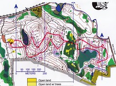
Orienteering race 15:02 [4] *** 2.1 km (7:10 / km) +100m 5:47 / km
shoes: Inov-8 Mudlcaw 330 August 2009
WCOC Hoyt Sprint #1, by Balter®
Of course, a quality product. True, part of the map was dodgy, and I probably lost 15-20 seconds there. Maybe 15 or 20 seconds on the rest of the course, too?
Of course, a quality product. True, part of the map was dodgy, and I probably lost 15-20 seconds there. Maybe 15 or 20 seconds on the rest of the course, too?
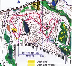
Orienteering race 11:15 [4] *** 1.6 km (7:02 / km) +90m 5:29 / km
shoes: Inov-8 Mudlcaw 330 August 2009
After chatting with George a bit, I took off on the 2nd sprint. Maybe a little physically and mentall off at first, but got in the groove after a few minutes.
Only real problem here was #9. Yes, a textbook mistake, and one I am susceptible to, but I'm not sure--I don't think things are quite right there.
Only real problem here was #9. Yes, a textbook mistake, and one I am susceptible to, but I'm not sure--I don't think things are quite right there.
Map Hike/Run 2:00:00 ****
shoes: Inov-8 Mudlcaw 330 August 2009
Off to Paugussett. Total time in the woods was 4:20. I'll count 2 hours of it, because a lot was making notes, streamering, standing still, etc. But, I did get some running in. And, at the end, I was dragging, not having had any food/drink after running earlier, aside from some pretzels and two cookies.
Generally pleased with how it went. It is really sweet terrain, and a decent map. Gari was quite a good amateur mapper. What a loss, in so many ways.
Still, I had some issues, but really minor ones. In a couple places I dumbed-down the controls a bit, moving them slightly to stronger, better mapped features. In a few instances, I may have a facing control situation, but that is better than a questionable feature. I think most my complaints were the union between brown and black. Steep cliff areas are trouble for anyone. I would throw up my hands at that, but a few other places, there are some minor geometry issues (very localized) and some inconsistency between black and brown.
But, so much is right. Point features, e.g., boulders and knolls were great. And the mapping in some of those thick areas is impressive.
The sad thing is that a lot of the map has been logged. I hope it can be updated by someone skilled so as to preserve the quality of this asset.