Training Log Archive: dbakkerIn the 12 days ending Aug 8, 2017:
| |||||||||||||||||||||||||||||||||||||||||||||||||||||||||||||||||||||||||||||||
| « | » |
| » now | ||||||||||||||||||
| Fr | Sa | Su | Mo | Tu | We | Th | Fr | Sa | Su | Mo | Tu | ||||||||||
Tuesday Aug 8, 2017 #
9 AM
Mapping 6:58:03 16.28 km (25:41 / km) +40m 25:22 / km
Fieldwork for the downtown Revelstoke map. This includes the downtown core, a bunch of residential, the rec. centre, Centennial Park, and both the current schools, as well as an old one. Some nice chunks of map, and some pretty boring chunks of map. Unofruntately there is no contour data, so I am having to draw that all by hand... good news is that for the most part it is fairly flat, with most of the elevation changes occuring on one large embankment between the schools and the park.
Smoke wasn't quite as bad in Revelstoke as in Salmon Arm.
Smoke wasn't quite as bad in Revelstoke as in Salmon Arm.
Monday Aug 7, 2017 #
10 AM
Mapping 3:54:44 6.14 km (38:15 / km) +200m 32:54 / km
(sick)
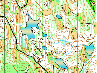
Finishing up the south east corner of the Canoe Creek map. The map is finished! If Sage Stomp is in Salmon Arm next year (waiting on email from Jackie to find out...), then I think we should save the map for then. I think the map is a little too challenging for a weeknight event, so don't really want to use it this fall.
This is the first map that is in ISOM2017 that I have made/seen. Note the vegetation boundary in the green dashes, otherwise not too much is different.
Map sample:
Just about over this cold.
This is the first map that is in ISOM2017 that I have made/seen. Note the vegetation boundary in the green dashes, otherwise not too much is different.
Map sample:
Just about over this cold.
9 PM
Streching/Rolling 10:00 [0]
Friday Aug 4, 2017 #
10 AM
Mapping 2:36:15 5.88 km (26:33 / km) +118m 24:09 / km
Started doing a chunk of mapping today, the north edge and under the east powerline, but just didn't have the energy, it was way too hot, and way too smokey. Ditched early and came back home.
Thursday Aug 3, 2017 #
Note
(sick)
Didn't go out mapping today. Sore throat, off and on fever, headache, and a bit stuffed up. Plus, it's really incredibly smokey out.
Wednesday Aug 2, 2017 #
10 AM
Mapping 6:03:48 8.43 km (43:08 / km) +81m 41:10 / km
Lots and lots of rock today, and a fair bit of white forest. This is going to make an excellent middle map. Lots of features everywhere: water, rock, vegetation, you name it.
Tuesday Aug 1, 2017 #
Note
Watched Dunkirk with Dad this evening. Wow! Very powerful movie, never seen (or heard, as the case may be) a theatre that quiet. Even when people left, dead silence, nobody talking. Simply put, we are damn lucky where and when we live.
10 AM
Mapping 6:38:20 8.45 km (47:07 / km) +106m 44:21 / km
Mapping out in Canoe Creek again. Still smokey.
Found a honey tree today! Quite literally. I had stopped walking around to draw on the tablet a bit, heard a buzzing noise and looked up. Honeybees flying in and out of a 3 inch wide hole in a cedar tree about 10 feet above my head! First wild honeybee hive that I have ever seen.
Map is progressing fairly well, but where I was today (the south-western chunk) was on the green side of things for sure. More rock than the northern parts that I have mapped though. I now have the south and central east of the map to do, as well as a small northern strip along the golf course.
Almost ran out of battery power on the tablet today, going to have to drop my brightness a bit if I want to map for longer than 7 hours in a day.
Monday Jul 31, 2017 #
10 AM
Mapping 5:44:25 7.01 km (49:10 / km) +57m 47:15 / km
Mapping in Canoe Creek (a working map name... I'm thinking The Deer Patch might be better?) out behind the Canoe Creek golf course, accessed from the industrial park. While the map is fairly green (but good for Salmon Arm standards - Better than Little Mountain, about on par, maybe a tad bit better than South Canoe), the patched clearcuts are quite runnable, and there is a lot of contour detail. It will make a good middle map.
I'll probably be mapping here all week.
Very smokey today, it rolled in last night. Couldn't see the mountains at all this morning from the house, but cleared up slightly during the day.
I'll probably be mapping here all week.
Very smokey today, it rolled in last night. Couldn't see the mountains at all this morning from the house, but cleared up slightly during the day.
Saturday Jul 29, 2017 #
10 AM
Mapping 3:40:41 5.73 km (38:32 / km) +68m 36:23 / km
Mapping Polson Park and the surrounding Hospital Grounds in Vernon. Should be a fun sprint map, the creek running through the park makes things interesting, as well as the ponds should create some interesting routechoices. The area around the hospital and care home as well is pretty good, lots of weirdly shaped buildings and impassable walls and fences.
Unfortunately, there are a lot of homeless camps in the park. I had not realized just how big the problem was from reading the Castanet stories, but there are a lot of unfortunate people living there. They are mostly in one small part of the park on the edge of the map, so shouldn't affect it's usage.
Unfortunately, there are a lot of homeless camps in the park. I had not realized just how big the problem was from reading the Castanet stories, but there are a lot of unfortunate people living there. They are mostly in one small part of the park on the edge of the map, so shouldn't affect it's usage.
8 PM
Running 20:39 [1] 3.24 km (6:23 / km) +95m 5:34 / km
Saw my third bear in as many days today in Little Mountain. Went out running way too late... ran out of daylight.
Friday Jul 28, 2017 #
10 AM
Mapping 3:16:24 4.89 km (40:08 / km) +50m 38:11 / km
Mapping the northern chunk of the new Canoe Creek map out behind the industrial park. Fairly green (but everything around here is...) but lots of nice contour detail. Our best map for that, but almost no rock. Has 3 roads, and 1 trail. A bunch of marshes and small ponds, and a powerline running the entire eastern edge of the map.
I think it will take around 15-18 hours altogether for this fairly small map of around 1.3 square km.
Bugs were surprisingly bad today (something to do with walking through marshes), and the heat was really bad too.
Counted at a bit under 1/3 time in zone1.
I think it will take around 15-18 hours altogether for this fairly small map of around 1.3 square km.
Bugs were surprisingly bad today (something to do with walking through marshes), and the heat was really bad too.
Counted at a bit under 1/3 time in zone1.