Training Log Archive: TrautIn the 7 days ending Sep 28, 2014:
| |||||||||||||||||||||||||||||||||||||||||||||||||||||||||||||||||||||||||||||||||||||||||||||||||||||||||||||||||||||||||||||||||||
| « | » |
| » now | ||||||||||||||||||||
| Mo | Tu | We | Th | Fr | Sa | Su | |||||||||||||||||
Sunday Sep 28, 2014 #
Event: WPOC Laurel Hill
12 PM
Orienteering 1:40:37 5.68 mi (17:43 / mi) +916ft 15:22 / mi
ahr:124 max:156 shoes: Inov8 OROC 280
WPOC Laurel Hill (www.wpoc.org)
Red Course
https://flic.kr/p/pcesat
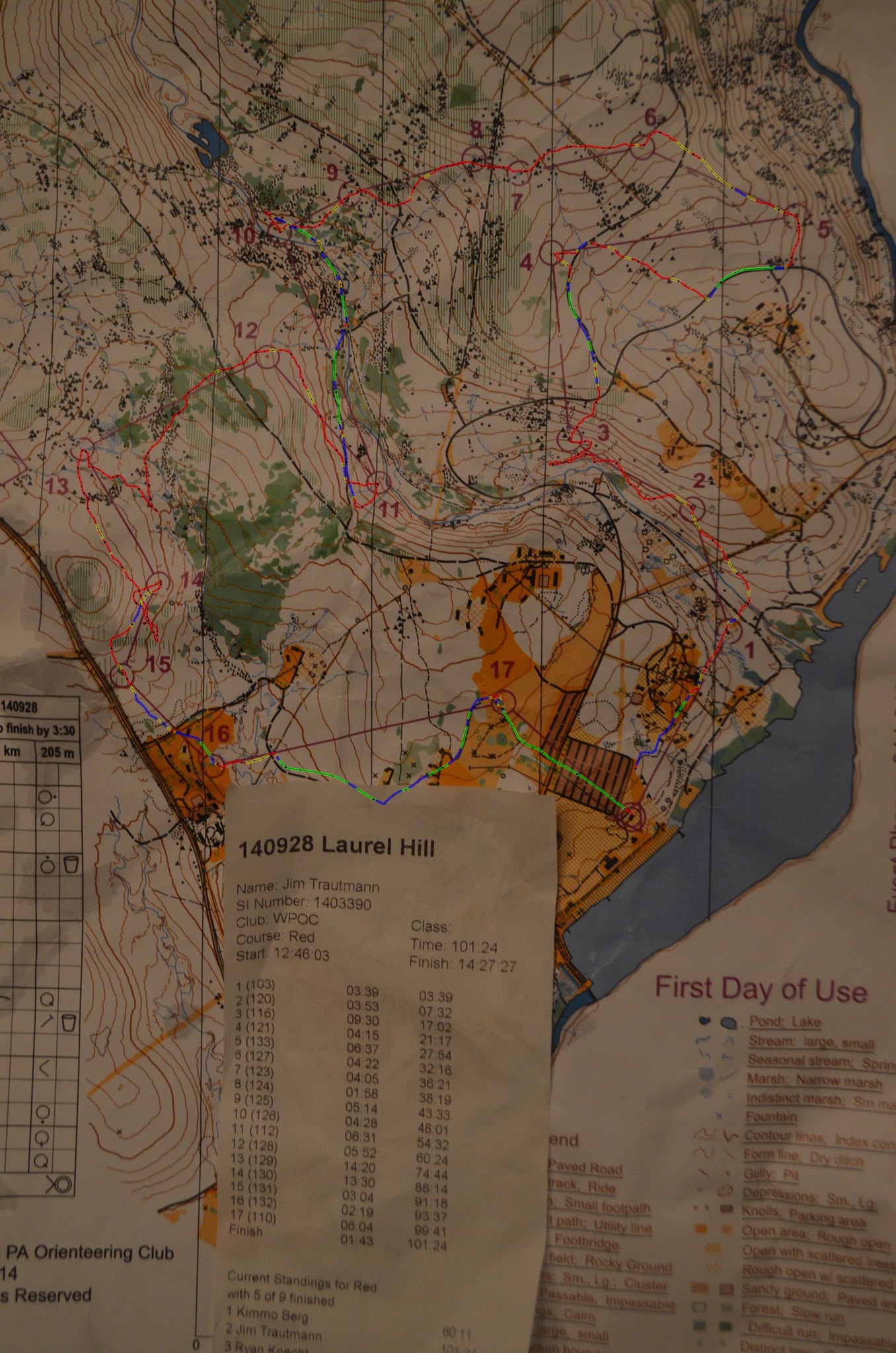
First orienteering meet since the spring. With my knee swelling up recently I only ran on open ground and trail. Knee felt really rough in the beginning, but did settle in as I went. I didn’t even try to do anything but walk easy in the woods, which was decently rocky terrain. This is by far the clubs best map and Jim’s courses were really great. Almost no fight at all.
Control one and two were fine, I took them pretty slow, but had no trouble. Control 3 was my first navigation issue. My plan was to just parallel the creek around the bend. My mistake was allowing myself to get too low and then having to go up around the green got me thinking I was higher then I was and I overshot the control underneath it.
Control number 4 was an easy shot. Most people stayed high and went down to number 5, but it made a lot more sense to me to go down and hit it from the paved road. There was no elevation loss and there was a very clear attack point with those rocks. I followed the nose of the hill up toward 6, but after crossing the dirt road I ended up a little bit east of the control.
#7 was a bearing. I ended up heading a bit north but I picked up the rock features and they took me right to the circle. #8 was an easy short bearing. #9 I dodged the undergrowth and used a bearing to get to the circle. One of the creeks went up further then mapped, but I trusted my bearing enough to keep going.
I was sloppy on number 10 as I thought I could see the control for the trail and overshot it more then I should have. I planned on cutting down to #11 earlier but came up on the water sooner then I thought I would. #12 went fine. I planned on heading out toward the reentrant and paralleling it up too the control.
#13 was worse then I thought it was. I guess I was the only one to head straight through the laurel. If I had cut around such an obvious vegetation line I could have used it to use the marsh as an attack point. Instead I did cut around one area that was a bit rough and somehow it allowed me to loose my bearing completely. At the creek I thought I was at the bend a little bit north of where I actually was, but my bearing got even worse from there. How did I start going due south? When reached the next creek it took some time for me to use the compass to realize the creek was heading the right way to be the creek the control was on. I was so much further off then I thought so I was committing a parallel error. I realized it at just the right time to cut over to the control.
#14 I made my mistake early and paid for it. I should have gone to the edge of the rocks on the east. I went straight through and thought I had a cliff picked out to start my bearing and I had the wrong cliff. My bearing was too far west and I ended up in a bunch of unmapped depressions west of the mapped ones before catching a glimpse of the control below. One cool thing was that I found a Turkey, probably nesting, in one depression. It took off about 5 feet from me like a Harrier Jet lifting off.
I aimed off and used the road to hit 15 right on. #16 and #17 were easy, although I had to go around the other side of the vegetation on #17.
Had a lot of fun out there, but I need to make it to more meets to improve my navigation.
Red Course
https://flic.kr/p/pcesat
First orienteering meet since the spring. With my knee swelling up recently I only ran on open ground and trail. Knee felt really rough in the beginning, but did settle in as I went. I didn’t even try to do anything but walk easy in the woods, which was decently rocky terrain. This is by far the clubs best map and Jim’s courses were really great. Almost no fight at all.
Control one and two were fine, I took them pretty slow, but had no trouble. Control 3 was my first navigation issue. My plan was to just parallel the creek around the bend. My mistake was allowing myself to get too low and then having to go up around the green got me thinking I was higher then I was and I overshot the control underneath it.
Control number 4 was an easy shot. Most people stayed high and went down to number 5, but it made a lot more sense to me to go down and hit it from the paved road. There was no elevation loss and there was a very clear attack point with those rocks. I followed the nose of the hill up toward 6, but after crossing the dirt road I ended up a little bit east of the control.
#7 was a bearing. I ended up heading a bit north but I picked up the rock features and they took me right to the circle. #8 was an easy short bearing. #9 I dodged the undergrowth and used a bearing to get to the circle. One of the creeks went up further then mapped, but I trusted my bearing enough to keep going.
I was sloppy on number 10 as I thought I could see the control for the trail and overshot it more then I should have. I planned on cutting down to #11 earlier but came up on the water sooner then I thought I would. #12 went fine. I planned on heading out toward the reentrant and paralleling it up too the control.
#13 was worse then I thought it was. I guess I was the only one to head straight through the laurel. If I had cut around such an obvious vegetation line I could have used it to use the marsh as an attack point. Instead I did cut around one area that was a bit rough and somehow it allowed me to loose my bearing completely. At the creek I thought I was at the bend a little bit north of where I actually was, but my bearing got even worse from there. How did I start going due south? When reached the next creek it took some time for me to use the compass to realize the creek was heading the right way to be the creek the control was on. I was so much further off then I thought so I was committing a parallel error. I realized it at just the right time to cut over to the control.
#14 I made my mistake early and paid for it. I should have gone to the edge of the rocks on the east. I went straight through and thought I had a cliff picked out to start my bearing and I had the wrong cliff. My bearing was too far west and I ended up in a bunch of unmapped depressions west of the mapped ones before catching a glimpse of the control below. One cool thing was that I found a Turkey, probably nesting, in one depression. It took off about 5 feet from me like a Harrier Jet lifting off.
I aimed off and used the road to hit 15 right on. #16 and #17 were easy, although I had to go around the other side of the vegetation on #17.
Had a lot of fun out there, but I need to make it to more meets to improve my navigation.
11 PM
PT 20:00 [2]
stretching and rolling. Step-downs and calf raises
PT 20:00 [2]
stretching and rolling. Step-downs and calf raises
Saturday Sep 27, 2014 #
7 PM
Road Biking 30:00 [2] 10.0 mi (20.0 mph)
Had Claire all day and could finally get out on the bike at dark. Got in a s much as I could. I had had a few walks in during the day and all I really wanted was just to keep my knee moving. The edema is up and my back is a mess. Logic would call this a time that my body is calling for rest, but arthritis is such a strange beast. I pushed a big gear and felt good form (eccentric/concentric "foot-strike") for a bit, but tightened even in such a short ride over the last few miles.
Friday Sep 26, 2014 #
6 AM
Nordic Track 20:00 [2]
back a little bit better, but still really deeply tight under traps. Tried Nordic Track despite. Got through. Right IT band was also very tight and struggled with form. Edema is also up in right knee. I know I need to keep moving, but this is a tough time. Focusing on from.
4 PM
Trail Running 46:17 4.78 mi (9:41 / mi) +832ft 8:19 / mi
ahr:141 max:171 shoes: Brooks PureConnect 2
Some days I do an experimental run and things just connect and work, then there are days like today... I had planned to use some of the neighborhood trails along the creeks across from North Boundary Park and connect up Garvin Rd. to the development across the street from the Power Station in and back in to North Boundary Park. I had a hunch that the radio tower would have trails that connect back down to the development an dI suspected that the trails that started on either side of the power-line would connect North Boundary Park through great fall goldenrod. It kind of worked...
First I forgot that there were still a few creek trails across Garvin rd. but that is OK- they aren't that interesting anyway. The run up Garvin and the dirt road up to the tower was a great little climb and nice fall shade. At the top there were two choices to head off on ATV type trails. One that headed out from the bend in the road on top and one that went down toward 79 from the tower. I choose the tower and it went down through a lot of weeds and a shrinking trail. I thought for sure I had some ticks on me I was moving so slow. I will mention how I felt later (that would also be nothing compared to the potential tick attachment time I spent on the power-line though). The trail also deposited me in a backyard so I had to bust through out to Marshall dr.
Then came the power-line... A nice sharp climb up to the little power station and all I could find was a little faded trail and I went with it and it vanished completely. I could see the trail on the other end and thought I could just push through... what a mess. I walked and bloodied myself through everything and I spent the next few hours with my skin reacting in every way possible... I showered and did a big tick check before picking Claire up but that seemed to agitate my skin.
On to how I felt. The edema in my knee is definitely up and everything felt tight and weak in my right knee. I slowed down and focused on form. This day ended up being an easy day with the stops and such and my knee did feel better in end of run. It was tender all evening though... I need to keep an eye on this growth in the edema.
Strava: http://www.strava.com/activities/199833524
Garmin: http://connect.garmin.com/activity/599510840
Thursday Sep 25, 2014 #
6 AM
Nordic Track 20:00 [2]
20 minute morning Nordic Track session. Upper back got so tight it may have been spasming in second half and is still feeling that way hours later.
5 PM
Aqua-jogging 45:00 [2]
upper back was cramping al day... it was awful. I headed to the pool, because maybe I could loosen up and couldn't think of trying to do anything else. I was actually nervous when I got in that hitting the cold water would create a total spasm, but I did get in and get a water run in. I did loosen up some, but it tightened up again after I was done. We'll see.
10 PM
PT 20:00 [2]
stretching and rolling, clams and straight-leg lifts
Wednesday Sep 24, 2014 #
6 AM
Nordic Track 20:00 [2]
20 minute nordic track session. Very tight.
5 PM
Road Running 41:35 6.17 mi (6:44 / mi) +655ft 6:07 / mi
ahr:154 max:167 shoes: Brooks PureConnect 2
I had an appointment with Dr. Ed and I have been craving a nice country roads fall run. Being up in Zelie was perfect. I had low expectations because I normally feel pretty bad right after each appointment when I run. I wanted to start with the climb up the Ben Venue dirt road that I biked months ago on the cross bike and then I headed out to the roads through the farms on the ridge and then down by Muntz run (which was residential, then farms, then woods by the creek). It was a beautiful run and while I felt really bad in the beginning, I felt really relaxed with great form by the end.
I struggled going up the hills in the first few miles, and just focused on form. As it does, the pace came in pretty good. It got better as we flattened out and I was relaxed and moving well downhill. Not s fast as I have been, even since the arthritis, but I felt so smooth....
Strava: http://www.strava.com/activities/199059187
Garmin: http://connect.garmin.com/activity/598265442
Avg Run Cadence: 176 spm
Max Run Cadence: 188 spm
Avg Vertical Oscillation: 9.9 cm
Avg Ground Contact Time: 240 ms
Avg Stride Length: 1.36 m
11 PM
PT 20:00 [2]
stretching and rolling. Step-downs and directional single leg squats
Tuesday Sep 23, 2014 #
6 AM
Nordic Track 20:00 [2]
20 minute Nordic Track session. Felt better then usual in knee till last 5-minutes when right IT band got tight and knee felt vulnerable.
5 PM
Aqua-jogging 50:00 [2]
50 minute aqua-jog at Y. Knee felt good. Had trouble finding form in first half but it came. Went for a 40 minute walk afterward as well.
11 PM
PT 20:00 [2]
stretching and rolling, straight leg lifts and clams.
Monday Sep 22, 2014 #
6 AM
Nordic Track 20:00 [2]
20 minute morning Nordic Track session. Felt OK.
11 AM
PT 20:00 [2]
stretching and rolling, step-downs and calf raises
5 PM
Trail Running 40:41 5.0 mi (8:08 / mi) +437ft 7:31 / mi
ahr:145 max:160 shoes: Brooks Pure Grit 2
Quads got really tight at the end of work, but run held together. In the beginning I was having difficulty with my foot-strike and my knee felt fairly vulnerable throughout, but as I went I did feel a better foot-strike and form. My pace was actually pretty quick (very quick on Strava- not sure why the discrepancy, but it is decent either way), and I felt very good in last few miles even though I did not feel good early.
It was a beautiful fall temperature and the colors are just starting. Wanted a trail run with a little road on the ridge and by the lake to see how a felt on that surface and to get a little road fall foliage look. It was about .6 of a mile maybe in total on road, but it was very nice up on the ridge- didn't see a single car on the nice windy road through the woods.
Metrics are OK, but not great. My knee definitely did feel vulnerable.
Strava: http://www.strava.com/activities/198196426
Garmin: http://connect.garmin.com/activity/596880526
Avg Run Cadence: 177 spm
Max Run Cadence: 255 spm
Avg Vertical Oscillation: 9.8 cm
Avg Ground Contact Time: 250 ms
Avg Stride Length: 1.12 m